


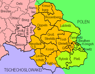
Regierungsbezirk Oppeln was a Regierungsbezirk , or government region, in the Prussian Province of Silesia, from 1813 to 1945, which covered the south-eastern part of Silesia.
Regierungsbezirk Oppeln was a Regierungsbezirk , or government region, in the Prussian Province of Silesia, from 1813 to 1945, which covered the south-eastern part of Silesia.
The capital of the Regierungsbezirk was the Upper Silesian city of Oppeln. Other important cities in the region included Kattowitz, Gleiwitz, Beuthen, Königshütte, Hindenburg, Ratibor, Neustadt, Neisse and Kreuzburg.
It comprised the following districts (as of 1910):
Urban districts | Rural districts
|
| Year | Polish | German | Other (including bilingual) | |||
|---|---|---|---|---|---|---|
| Number | Percentage | Number | Percentage | Number | Percentage | |
| 1819 [1] | 377,100 | 67.2% | 162,600 | 29.0% | 21,503 | 3.8% |
| 1828 [2] | 418,437 | 61.1% | 255,483 | 37.3% | 10,904 | 1.6% |
| 1831 [2] | 456,348 | 62.0% | 257,852 | 36.1% | 13,254 | 1.9% |
| 1834 [2] | 468,691 | 62.6% | 266,399 | 35.6% | 13,120 | 1.8% |
| 1837 [2] | 495,362 | 62.1% | 290,168 | 36.3% | 12,679 | 1.6% |
| 1840 [2] | 525,395 | 58.6% | 330,099 | 36.8% | 41,570 | 4.6% |
| 1843 [2] | 540,402 | 58.1% | 348,094 | 37.4% | 42,292 | 4.5% |
| 1846 [2] | 568,582 | 58.1% | 364,175 | 37.2% | 45,736 | 4.7% |
| 1852 [2] | 584,293 | 58.6% | 363,990 | 36.5% | 49,445 | 4.9% |
| 1855 [2] | 590,248 | 58.7% | 366,562 | 36.5% | 48,270 | 4.8% |
| 1858 [2] | 612,849 | 57.3% | 406,950 | 38.1% | 49,037 | 4.6% |
| 1861 [2] | 665,865 | 59.1% | 409,218 | 38.3% | 51,187 | 4.6% |
| 1867 [2] | 742,153 | 59.8% | 457,545 | 36.8% | 41,611 | 3.4% |
| 1890 [2] | 918,728 | 58.2% | 566,523 | 35.9% | 92,480 | 5.9% |
| 1900 [2] | 1,048,230 | 56.1% | 684,397 | 36.6% | 135,519 | 7.3% |
| 1905 [2] | 1,158,805 | 56.9% | 757,200 | 37.2% | 117,651 | 5.8% |
| 1910 [2] | 1,169,340 | 53.0% | 884,045 | 40.0% | 154,596 | 7.0% |
| District | Population | Polish | % | German | % | Bilingual | % | Czech | % |
|---|---|---|---|---|---|---|---|---|---|
| Landkreis Beuthen | 195,844 | 123,016 | 62.8% | 59,308 | 30.3% | 11,695 | 6.0% | 94 | 0.0% |
| Stadtkreis Beuthen | 67,718 | 22,401 | 33.1% | 41,071 | 60.7% | 3,504 | 5.2% | 55 | 0.1% |
| Falkenberg | 37,526 | 3,815 | 10.2% | 33,286 | 88.7% | 365 | 1.0% | 1 | 0.0% |
| Stadtkreis Gleiwitz | 66,981 | 9,843 | 14.7% | 49,543 | 74.0% | 7,461 | 11.1% | 46 | 0.1% |
| Groß Strehlitz | 73,383 | 58,102 | 79.2% | 12,616 | 17.2% | 1,783 | 2.4% | 870 | 1.2% |
| Grottkau | 40,610 | 825 | 2.0% | 39,589 | 97.5% | 129 | 0.3% | 26 | 0.1% |
| Landkreis Kattowitz | 216,807 | 140,592 | 64.8% | 65,763 | 30.3% | 7,430 | 3.4% | 98 | 0.0% |
| Stadtkreis Kattowitz | 43,173 | 5,766 | 13.4% | 36,891 | 85.4% | 365 | 0.8% | 13 | 0.0% |
| Stadtkreis Königshütte | 72,641 | 24,687 | 34.0% | 39,276 | 54.1% | 8,366 | 11.5% | 26 | 0.0% |
| Kosel | 75,673 | 56,794 | 75.1% | 16,433 | 21.7% | 2,303 | 3.0% | 90 | 0.1% |
| Kreuzburg | 51,906 | 24,487 | 47.2% | 24,363 | 46.9% | 3,002 | 5.8% | 10 | 0.0% |
| Leobschütz | 82,635 | 5,178 | 6.3% | 69,901 | 84.6% | 1,200 | 1.5% | 6,311 | 7.6% |
| Lublinitz | 50,388 | 39,969 | 79.3% | 7,384 | 14.7% | 2,885 | 5.7% | 138 | 0.3% |
| Neisse | 101,223 | 1,752 | 1.7% | 98,860 | 97.7% | 380 | 0.4% | 95 | 0.1% |
| Neustadt | 97,537 | 43,787 | 44.9% | 51,489 | 52.8% | 2,182 | 2.2% | 63 | 0.1% |
| Landkreis Oppeln | 117,906 | 89,323 | 75.8% | 23,740 | 20.1% | 2,955 | 2.5% | 1,852 | 1.6% |
| Stadtkreis Oppeln | 33,907 | 5,371 | 15.8% | 27,128 | 80.0% | 1,385 | 4.1% | 6 | 0.0% |
| Pleß | 122,897 | 105,744 | 86.0% | 16,464 | 13.4% | 447 | 0.4% | 24 | 0.0% |
| Landkreis Ratibor | 118,923 | 56,765 | 47.7% | 13,316 | 11.2% | 1,576 | 1.3% | 47,209 | 39.7% |
| Stadtkreis Ratibor | 38,424 | 11,525 | 30.0% | 22,914 | 59.6% | 3,684 | 9.6% | 247 | 0.6% |
| Rosenberg | 52,341 | 42,234 | 80.7% | 8,586 | 16.4% | 1,514 | 2.9% | 2 | 0.0% |
| Rybnik | 131,630 | 102,430 | 77.8% | 24,872 | 18.9% | 3,636 | 2.8% | 24 | 0.0% |
| Tarnowitz | 77,583 | 51,858 | 66.8% | 20,969 | 27.0% | 4,742 | 6.1% | 3 | 0.0% |
| Tost-Gleiwitz | 80,515 | 61,509 | 76.4% | 16,408 | 20.4% | 2,535 | 3.1% | 0 | 0.0% |
| Zabrze | 159,810 | 81,567 | 51.0% | 63,875 | 40.0% | 13,973 | 8.7% | 44 | 0.0% |
| Total | 2,207,981 | 1,169,340 | 53.0% | 884,045 | 40.0% | 89,497 | 4.1% | 57,347 | 2.6% |

Silesian Voivodeship, or Silesia Province is a voivodeship, or province, in southern Poland, centered on the historic region known as Upper Silesia, with Katowice serving as its capital.

A Regierungsbezirk means "governmental district" and is a type of administrative division in Germany. Four of sixteen Bundesländer are split into Regierungsbezirke. Beneath these are rural and urban districts.

The Province of Silesia was a province of Prussia from 1815 to 1919. The Silesia region was part of the Prussian realm since 1740 and established as an official province in 1815, then became part of the German Empire in 1871. In 1919, as part of the Free State of Prussia within Weimar Germany, Silesia was divided into the provinces of Upper Silesia and Lower Silesia. Silesia was reunified briefly from 1 April 1938 to 27 January 1941 as a province of Nazi Germany before being divided back into Upper Silesia and Lower Silesia.
The Upper Silesia plebiscite was a plebiscite mandated by the Versailles Treaty and carried out on 20 March 1921 to determine ownership of the province of Upper Silesia between Weimar Germany and Poland. The region was ethnically mixed with both Germans and Poles; according to prewar statistics, ethnic Poles formed 60 percent of the population. Under the previous rule by the German Empire, Poles claimed they had faced discrimination, making them effectively second class citizens. The period of the plebiscite campaign and inter-Allied occupation was marked by violence. There were three Polish uprisings, and German volunteer paramilitary units came to the region as well.

Regierungsbezirk Breslau, known colloquially as Middle Silesia was a Regierungsbezirk, or government region, in the Prussian Province of Silesia and later Lower Silesia from 1813 to 1945. It comprised the eastern parts of the historic Lower Silesia region and the former County of Kladsko, both of which were conquered by Prussia in the First Silesian War in 1742.
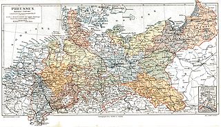
The Provinces of Prussia were the main administrative divisions of Prussia from 1815 to 1946. Prussia's province system was introduced in the Stein-Hardenberg Reforms in 1815, and were mostly organized from duchies and historical regions. Provinces were divided into several Regierungsbezirke, sub-divided into Kreise (districts), and then into Gemeinden (townships) at the lowest level. Provinces constituted the highest level of administration in the Kingdom of Prussia and Free State of Prussia until 1933, when Nazi Germany established de facto direct rule over provincial politics, and were formally abolished in 1946 following World War II. The Prussian provinces became the basis for many federal states of Germany, and the states of Brandenburg, Lower Saxony, and Schleswig-Holstein are direct successors of provinces.

The Province of Upper Silesia was a province of the Free State of Prussia from 1919 to 1945. It comprised much of the region of Upper Silesia and was eventually divided into two government regions (Regierungsbezirke) called Kattowitz (1939-1945), and Oppeln (1819-1945). The provincial capital was Oppeln (1919–1938) and Kattowitz (1941–1945), while other major towns included Beuthen, Gleiwitz, Hindenburg O.S., Neiße, Ratibor and Auschwitz, added in 1941. Between 1938 and 1941 it was reunited with Lower Silesia as the Province of Silesia.

Łąka Prudnicka is a village in the administrative district of Gmina Prudnik, within Prudnik County, Opole Voivodeship, in south-western Poland, close to the Czech border. It lies approximately 4 kilometres (2 mi) west of Prudnik and 49 km (30 mi) south-west of the regional capital Opole.

Moszczanka is a village in the administrative district of Gmina Prudnik, within Prudnik County, Opole Voivodeship, in south-western Poland, close to the Czech border.
East Upper Silesia is the easternmost extremity of Silesia, the eastern part of the Upper Silesian region around the city of Katowice. The term is used primarily to denote those areas that became part of the Second Polish Republic on 20 June 1922, as a consequence of the post-World War I Treaty of Versailles. Prior to World War II, the Second Polish Republic administered the area as Autonomous Silesian Voivodeship. East Upper Silesia was also known as Polish (Upper) Silesia, and the German (Upper) Silesia was known as West Upper Silesia.

Michael Graf von Matuschka was a German politician who took part in the 20 July plot.

Baranowice is a rural district (dzielnica) in the municipality of Żory since 1975, in the Silesian Voivodeship, southern Poland. Up until 1945, and between 1973–1975, it constituted an independent rural district in the historical and geographical region of Upper Silesia. Baranowice encompasses an area of 1,291 hectares and is the largest of all the districts of Żory.

Landkreis Kreuzburg O.S. was a Prussian district in Silesia, from 1742 to 1945, with its capital at Kreuzburg O.S. Today, the region is part of the Polish Opole Voivodeship.
Landkreis Leobschütz was a Prussian district in Silesia, from 1743 to 1945, with its capital at Leobschütz. Its historical roots lie in the Duchy of Leobschütz.

The Groß Wartenberg district, known until 1888 as the Wartenberg district, was a Prussian district in Silesia from 1742 to 1945. Its capital was the town of Groß Wartenberg, which was known until 1888 as Polnisch Wartenberg. The area of this district now lies within the Lower Silesian Voivodeship of Poland.
The District of Oels was a Prussian district in Silesia, which existed from 1742 to 1945. Its capital was the city of Oels. Today, the territory of this district is part of the Polish Lower Silesian Voivodeship.

The Rybnik district was a Prussian district in Upper Silesia from 1818 to 1926. Its capital was the city of Rybnik. The territory of this district is now in the Silesian Voivodeship in Poland.

The Rychtal Region, known in German as Reichthaler Ländchen is the north-eastern part of the former Silesian district of Namslau located around the town of Rychtal (Reichthal), which was ceded by Germany to Poland after World War I.
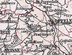
The Falkenberg O.S. district was a Prussian district in Upper Silesia, which existed from 1743 to 1945. Its capital was the town of Falkenberg O.S. The territory of this district is now located within the Opole Voivodeship of Poland.

The Neustadt O.S. district was a Prussian district in Upper Silesia from 1743 to 1945. Its capital was the city of Neustadt. Its territory corresponded roughly to the present-day Prudnik County in the Opole Voivodeship in Poland.
| General | |
|---|---|
| National libraries | |