
Tahiti is the largest island of the Windward group of the Society Islands in French Polynesia. It is located in the central part of the Pacific Ocean and the nearest major landmass is Australia. Divided into two parts, Tahiti Nui and Tahiti Iti, the island was formed from volcanic activity; it is high and mountainous with surrounding coral reefs. Its population was 189,517 in 2017, making it by far the most populous island in French Polynesia and accounting for 68.7% of its total population.
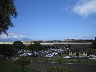
Faa'a International Airport, also known as Tahiti International Airport, is the international airport of French Polynesia, located in the commune of Faaa, on the island of Tahiti. It is situated 5 km (3.1 mi) southwest of Papeete, the capital city of the overseas collectivity. It opened in 1960. Regional air carrier Air Tahiti and international air carrier Air Tahiti Nui are both based at the airport.

Papeʻete is the capital city of French Polynesia, an overseas collectivity of the French Republic in the Pacific Ocean. The commune of Papeʻete is located on the island of Tahiti, in the administrative subdivision of the Windward Islands, of which Papeʻete is the administrative capital. The French High Commissioner also resides in Papeʻete.

Bora Bora is an island group in the Leeward Islands. The Leeward Islands comprise the western part of the Society Islands of French Polynesia, which is an overseas collectivity of the French Republic in the Pacific Ocean. Bora Bora has a total land area of 30.55 km2 (12 sq mi). The main island, located about 230 kilometres northwest of Papeete, is surrounded by a lagoon and a barrier reef. In the center of the island are the remnants of an extinct volcano, rising to two peaks, Mount Pahia and Mount Otemanu; the highest point is at 727 m (2,385 ft). Bora Bora is part of the Commune of Bora-Bora, which also includes the atoll of Tūpai. The languages spoken in Bora Bora are Tahitian and French. However, due to the high tourism population, many natives of Bora Bora have learned to speak English.

Moʻorea, also spelled Moorea, is a volcanic island in French Polynesia. It is one of the Windward Islands, a group that is part of the Society Islands, 17 kilometres (11 mi) northwest of Tahiti. The name comes from the Tahitian word Moʻoreʻa, meaning "yellow lizard": Moʻo = lizard ; Reʻa = yellow. An older name for the island is ʻAimeho, sometimes spelled ʻAimeo or ʻEimeo. Early Western colonists and voyagers also referred to Moʻorea as York Island or Santo Domingo.

Rikitea is a small town on Mangareva, which is part of the Gambier Islands in French Polynesia. A majority of the islanders live in Rikitea. The island was a protectorate of France in 1871 and was annexed in 1881.
Faʻaʻā is a commune in the suburbs of Papeʻete in French Polynesia, an overseas country of France in the Pacific Ocean. Faʻaʻā is located on the island of Tahiti, in the administrative subdivision of the Windward Islands, themselves part of the Society Islands. At the 2017 census Faʻaʻā had a population of 29,506, making it the most populous commune on Tahiti and in French Polynesia. Faʻaʻā has many mountains inland that can reach 1,500 m (5,000 ft). Mount Marau is an extinct volcano in the inland limits and can be seen from nearby Moʻorea. The area of Faʻaʻā is 9 m (30 ft) above mean sea level on average.

Uturoa is a commune located in Raiatea, the largest island of the Îles Sous le Vent in French Polynesia. It is situated in between the administrative subdivision of Leeward Islands and the main port of the island of Raiatea. According to the 2017 census, Uturoa has a population of 3,778 individuals. The commune spans approximately 120 miles (193.121 km) northwest of Papeete, the capital of French Polynesia.

Māhina is a commune in the north of Tahiti in French Polynesia, an overseas territory of France in the Pacific Ocean. Māhina is located on the island of Tahiti, in the administrative subdivision of the Windward Islands, themselves part of the Society Islands. Māhina is the 5th most populous commune in French Polynesia with a population of 14,764, in an area of 52 km2. Mount Orohena is a nearby mountain.

Pā'ea is a commune in the suburbs of Pape'ete in French Polynesia, an overseas territory of France in the southern Pacific Ocean. Pā'ea is located on the island of Tahiti, in the administrative subdivision of the Windward Islands, themselves part of the Society Islands. At the 2017 census it had a population of 13,021.

The Society Islands are an archipelago located in the South Pacific Ocean. Politically, they are part of French Polynesia, an overseas country of the French Republic. Geographically, they form part of Polynesia.
Edgar William Leeteg was an American painter often considered the father of American velvet painting. He immigrated to French Polynesia in 1933, where he spent the rest of his life painting the local life on black velvet.
Tautira is a Polynesian beach village, valley, and point on the south-east coast of the island of Tahiti in the Pacific. It is part of the commune Taiarapu-Est. With a population of 2338, it is located 49 kilometres southeast of the Tahitian capital of Papeete on the coast of Tautira Bay, at the end of what is the largest valley of the Taiarapu Peninsula. Domingo de Bonechea visited the area in 1772 and attempted to spread Christianity here; James Cook landed at Tautira Bay during his voyage. Robert Louis Stevenson referred to the village as “The Garden of the World”, staying here to recover from illness in 1886. The village contains a Catholic church.

Moorea Airport is an airport serving the island of Moorea in French Polynesia, France. It is also known as Temae Airport or Moorea Temae Airport for its location near the village of Temae in northeastern Moorea. The airport is located 7.5 km (4.0 NM) northeast of Afareitu, the island's main village. It is also 15 km (8.1 NM) west of the island of Tahiti. The airport opened on October 6, 1967.

Air Moorea Flight 1121 was a de Havilland Canada DHC-6 Twin Otter which crashed into the ocean shortly after takeoff from Moorea Airport on Moorea Island in French Polynesia on 9 August 2007, killing all 20 people on board.
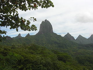
Mount Tohivea is an extinct volcano on the island of Mo'orea in French Polynesia. It is the island's highest point at 1,207 metres (3,960 ft). The mountain is about 2 miles (3.2 km) from Pao Pao, and is easily visible from Papeete, the capital of French Polynesia.

Severe Tropical Cyclone Wasa–Arthur was the first major tropical cyclone to affect French Polynesia and Tahiti since the 1982–83 season. The system was first noted on December 3, 1991, as a shallow tropical depression that was embedded within the monsoon trough, to the north of the Cook Island: Rarotonga. Over the next couple of days the system gradually developed further, before it was classified as a tropical cyclone and named Wasa during December 5. The system gradually strengthened further and acquired hurricane-force winds on December 6, as it performed a small clockwise loop. After completing the loop, Wasa moved southwards before it peaked in intensity during December 8, with sustained wind speeds of 165 km/h (105 mph). Over the next few days the system started to weaken as it passed through the French Polynesian Society Islands, and became the first major tropical cyclone to affect French Polynesia since 1983.

Vaitape is the largest city of Bora Bora Island in French Polynesia. It has a population of 4,927, about half of the island's population which is about 9,000. It is located about 210 km (130 mi) northwest of Papeete, the capital of French Polynesia. The main language of Vaitape is French, although 20 percent of the population speaks Tahitian.

Pao Pao is an associated commune on the island of Moʻorea, in French Polynesia. It is part of the commune Moʻorea-Maiʻao. According to a census in 2007, it had a population of 4,244 people. According to the 2012 census, it had grown to a population 4,580 people. In the 2017 census, it had grown to a population of 4,639. It is the largest village in Moʻorea.

The COVID-19 pandemic was confirmed to have reached the French overseas collectivity of French Polynesia in March 2020. As of 24 August 2021, French Polynesia has been the worst affected country in Oceania both in terms of proportion relative to population of total confirmed cases and total deaths. French Polynesia has experienced two significant outbreak waves, the first between September 2020 - January 2021, and the ongoing second wave which began in July 2021.
