Orange Grove, United States Virgin Islands | |
|---|---|
Village | |
| Country | |
| Island | Saint Croix |
| Time zone | UTC-4 (AST) |
Orange Grove is a settlement on the island of Saint Croix in the United States Virgin Islands.
Orange Grove, United States Virgin Islands | |
|---|---|
Village | |
| Country | |
| Island | Saint Croix |
| Time zone | UTC-4 (AST) |
Orange Grove is a settlement on the island of Saint Croix in the United States Virgin Islands.

Rock Point is a census-designated place (CDP) in Apache County, Arizona, United States. The population was 642 at the 2010 census. Its name is descriptive of the point where Chinle Creek enters some high sandstone walls.

Okahumpka is an unincorporated community and census-designated place (CDP) in Lake County, Florida, United States. The population was 267 at the 2010 census. It is part of the Orlando–Kissimmee Metropolitan Statistical Area.

Walnut Grove is a town in Walton County, Georgia, United States. The population was 1,330 according to the 2010 census.

Troy Township is a township in Bradford County, Pennsylvania, United States. The population was 1,645 at the 2010 census. Children residing in the township are assigned to attend the Troy Area School District.

Oak Grove is a town in Dodge County, Wisconsin, United States. The population was 1,126 at the 2000 census. The unincorporated communities of Minnesota Junction and Oak Grove are located in the town. The unincorporated community of Rolling Prairie is also located partially in the town.

Cruz Bay, U.S. Virgin Islands is the main town on the island of Saint John in the United States Virgin Islands. According to the 2000 census, Cruz Bay had a population of 2,743.
Kēōkea is an unincorporated populated place in Hawaiʻi County, Hawaii, United States. It is located at 19°25′10″N155°52′58″W, near the junction of Māmalahoa Highway and Keala o Keawe Road, elevation 960 feet. Satellite imagery shows evidence of a humid climate with agriculture dominant around the settlement. Just to the north is the area of Hōnaunau. It was the name for the land division (ahupuaʻa) of ancient Hawaiʻi that stretched from the shoreline to Mauna Loa owned by Mataio Kekūanāoa.

Moravian Brethren Mission House or Herrnhut House is a historical building in Nuuk, the capital of Greenland, established in 1747 from timber shipped to the United Brethren from the Netherlands. It was the centre of the Moravian Brethren Mission in Greenland and the missionaries operated across the west coast of Greenland from this building. Greenlander converts were reported saying, "If it can be so beautiful here on Earth, how wonderful must it not be in Heaven."
Cane Valley is a settlement on the island of Saint Croix in the United States Virgin Islands.
Castle Coakley is a settlement on the island of Saint Croix in the United States Virgin Islands.
Cotton Grove is a settlement on the island of Saint Croix in the United States Virgin Islands.
Fredensdal is a settlement on the island of Saint Croix in the United States Virgin Islands.
Golden Grove is a settlement on the island of Saint Croix in the United States Virgin Islands.
Grove Place is a settlement on the island of Saint Croix in the United States Virgin Islands.
Mon Bijou is a settlement on the island of Saint Croix in the United States Virgin Islands.
Sion Farm is a settlement on the island of Saint Croix in the United States Virgin Islands.
William is a settlement on the island of Saint Croix in the United States Virgin Islands.
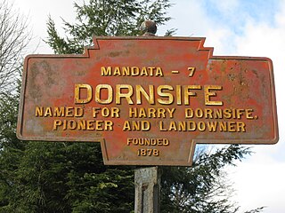
Dornsife is a populated place in Little Mahanoy Township, Northumberland County, Pennsylvania, United States, with a ZIP code of 17823. As of the 2010 U.S. Census, the ZIP Code Tabulation Area had a population of 1,273, with a median age of 41.9.
Carlisle is an unincorporated community in Noble County, in the U.S. state of Ohio.
Coordinates: 17°44′44″N64°43′10″W / 17.74556°N 64.71944°W
| | This Saint Croix, United States Virgin Islands location article is a stub. You can help Wikipedia by expanding it. |