Aruba is an island and a constituent country of the Kingdom of the Netherlands in the southern Caribbean Sea, located about 1,000 kilometres (620 mi) west of the main part of the Lesser Antilles and 29 kilometres (18 mi) north of the coast of Venezuela. It measures 32 kilometres (20 mi) long from its northwestern to its southeastern end and 10 kilometres (6 mi) across at its widest point. Together with Bonaire and Curaçao, Aruba forms a group referred to as the ABC islands. Collectively, Aruba and the other Dutch islands in the Caribbean are often called the Dutch Caribbean.

The Encyclopædia Britannica is a general knowledge English-language encyclopaedia. It was formerly published by Encyclopædia Britannica, Inc., and other publishers. It was written by about 100 full-time editors and more than 4,000 contributors. The 2010 version of the 15th edition, which spans 32 volumes and 32,640 pages, was the last printed edition.

The Pacific Ocean is the largest and deepest of Earth's oceanic divisions. It extends from the Arctic Ocean in the north to the Southern Ocean in the south and is bounded by the continents of Asia and Australia in the west and the Americas in the east.
The Vandals were a large East Germanic tribe or group of tribes that first appear in history inhabiting present-day southern Poland. Some later moved in large numbers, including most notably the group which successively established Vandal kingdoms in the Iberian Peninsula, on western Mediterranean islands and in North Africa in the 5th century.
Aruba's first inhabitants were the Caquetio Indians from the Arawak tribe, who migrated there from Venezuela to escape attacks by the Caribs. Fragments of the earliest known Indian settlements date back to about 1000. Due to Aruba's mostly distant location from other Caribbean islands and strong currents in the sea which made canoe travel to the other islands difficult, the Caquetios remained more tied to South America than the Caribbean.

Aruba is an island in the south of the Caribbean in the Caribbean Sea. It is westernmost island of the ABC Islands and of the Leeward Antilles. It is located 25 km north of the coast of Venezuela and 68 km northwest of Curaçao. The island has a total area of 193 km2 (75 sq mi) and a coast line of 68.5 km (42.6 mi). Mount Jamanota of 188 m (617 ft) is the highest point.

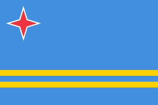
The following is an alphabetical list of topics related to the nation of Aruba.

Oranjestad is the capital and largest city of Aruba. Oranjestad is located on the southern coast near the western end of the island country. In the local language, Papiamento, Oranjestad is often referred to simply as "Playa". As of 2015, the population of the capital was around 35,000.
Vlorë County is one of the 12 counties of the Republic of Albania with the capital in Vlorë. The county spans 2,706 square kilometres (1,045 sq mi) and has a total population of 183,105 people as of 2016. It borders the counties of Fier and Gjirokastër, as well as the Adriatic and Ionian Sea.
This is a list of the Legislative Assemblies of Canada's provinces and territories. Each province's legislative assembly, along with the province's Lieutenant Governor, form the province's legislature. Historically, several provinces had bicameral legislatures, but they all eventually dissolved their upper house or merged it with their lower house.

Providenciales is an island in the northwest Caicos Islands, part of the Turks and Caicos Islands, a British Overseas Territory. The island has an area of 98 km2 (38 sq mi) and a 2012 Census population of 23,769. Providenciales is the largest island in population, the third largest in area, and is home to a large majority of the population of the Turks and Caicos Islands. Providenciales was ranked the best beach destination in the world by TripAdvisor in 2011.

Caquetio, Caiquetio, or Caiquetia are natives of northwestern Venezuela, living along the shores of Lake Maracaibo at the time of the Spanish conquest. They moved inland to avoid enslavement by the Spaniards, while their numbers were drastically affected by colonial warfare, as were their neighbours, the Quiriquire and the Jirajara. The Caquetíos were also present in Aruba, Curaçao and Bonaire when these islands were first colonized by Alonso de Ojeda in 1499. The occupants of this region were known as Caquetíos by the Spaniards and their language (Caquetío) belongs to the Arawakan family of languages. The Caquetío and the Jirajara spoke the same language, and their cultures were quite similar. The Arawakan or Caquetío language is termed a "ghost" language because virtually no trace of it survives. Only the name remains, saved in 17th-century texts.

Alto Vista Chapel is a small Catholic chapel also known as "Pilgrims Church" that stands on the hills above the north shore of the sea and to the northeast of the town of Noord, on the island of Aruba, 27 km north of the coast of Venezuela. The church, painted on the outside in stark bright yellow, makes it a conspicuous religious monument for people to visit. The present Chapel of Alto Vista was completed in 1952 and stands in the same location as the original chapel, which was built by Domingo Silvestre, the Venezuelan missionary from Santa Ana de Coro, Venezuela, in 1750.

Ayo Rock Formations are monolithic rock boulders located on the island of Aruba in the Caribbean. They are located near Ayo village, about 3.2 km from the natural bridge towards Casibari. Casibari Boulders are about 3.2 km inland between Natural Bridge and Oranjestad, the capital of Aruba, west of Boca Andicuri.

Palm Beach is a tourism district about 6 kilometers northwest of Oranjestad, the capital of Aruba. A number of high rise hotels are located there, such as Hyatt Regency Aruba Resort & Casino, Aruba Marriott Resort, Occidental Grand Aruba, Holiday Inn SunSpree Resort, Ritz Carlton Resort, and RIU palace Aruba. A shopping district adjacent to the hotels was finished in 2009, called Palm Beach Plaza Mall. Little North of Palm Beach is Malmok Beach, a small sandy strip running all the way until the northern tip of Aruba. Smaller apartment complexes and luxurious holiday homes are located along this dead-end Boulevard. Hadicurari Beach (kiting), Arashi Beach and Boca Catalina (snorkeling) are popular location.

Mada'in Saleh, also called Al-Ḥijr or "Hegra", is an archaeological site located in the Sector of Al-`Ula within Al Madinah Region in the Hejaz, Saudi Arabia. A majority of the remains date from the Nabatean kingdom. The site constitutes the kingdom's southernmost and largest settlement after Petra, its capital. Traces of Lihyanite and Roman occupation before and after the Nabatean rule, respectively, can also be found.
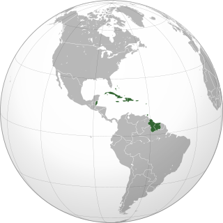
The Caribbean is a region of the Americas that consists of the Caribbean Sea, its islands and the surrounding coasts. The region is southeast of the Gulf of Mexico and the North American mainland, east of Central America, and north of South America.
Festivals in Aruba take place all year round on the island. Many of these colorful and entertaining cultural events that are recognized internationally and draw tourists from around the globe.

The Attack on Aruba was an attack on oil installations and tankers by Axis submarines during World War II. On 16 February 1942, a German U-boat attacked the small Dutch island of Aruba. Other submarines patrolled the area for shipping and they sank or damaged tankers. Aruba was home to two of the largest oil refineries in the world during the war against the Axis powers, the Arend Petroleum Maatschappij, situated near the Oranjestad harbor, and the Lago Oil and Transport Company at the San Nicolas harbor. The attack resulted in the disruption of vital Allied fuel production.
