Related Research Articles

Paleoclimatology is the scientific study of climates predating the invention of meteorological instruments, when no direct measurement data were available. As instrumental records only span a tiny part of Earth's history, the reconstruction of ancient climate is important to understand natural variation and the evolution of the current climate.
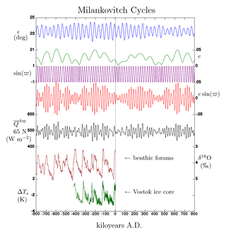
Milankovitch cycles describe the collective effects of changes in the Earth's movements on its climate over thousands of years. The term was coined and named after the Serbian geophysicist and astronomer Milutin Milanković. In the 1920s, he hypothesized that variations in eccentricity, axial tilt, and precession combined to result in cyclical variations in the intra-annual and latitudinal distribution of solar radiation at the Earth's surface, and that this orbital forcing strongly influenced the Earth's climatic patterns.
In the study of past climates ("paleoclimatology"), climate proxies are preserved physical characteristics of the past that stand in for direct meteorological measurements and enable scientists to reconstruct the climatic conditions over a longer fraction of the Earth's history. Reliable global records of climate only began in the 1880s, and proxies provide the only means for scientists to determine climatic patterns before record-keeping began.
Orbital forcing is the effect on climate of slow changes in the tilt of the Earth's axis and shape of the Earth's orbit around the Sun. These orbital changes modify the total amount of sunlight reaching the Earth by up to 25% at mid-latitudes. In this context, the term "forcing" signifies a physical process that affects the Earth's climate.

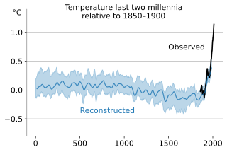
The global temperature record shows the fluctuations of the temperature of the atmosphere and the oceans through various spans of time. There are numerous estimates of temperatures since the end of the Pleistocene glaciation, particularly during the current Holocene epoch. Some temperature information is available through geologic evidence, going back millions of years. More recently, information from ice cores covers the period from 800,000 years before the present time until now. A study of the paleoclimate covers the time period from 12,000 years ago to the present. Tree rings and measurements from ice cores can give evidence about the global temperature from 1,000-2,000 years before the present until now. The most detailed information exists since 1850, when methodical thermometer-based records began. Modifications on the Stevenson-type screen were made for uniform instrument measurements around 1880.

Solar irradiance is the power per unit area received from the Sun in the form of electromagnetic radiation in the wavelength range of the measuring instrument. Solar irradiance is measured in watts per square metre (W/m2) in SI units.

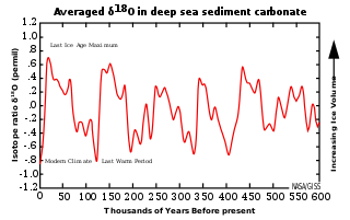
Marine isotope stages (MIS), marine oxygen-isotope stages, or oxygen isotope stages (OIS), are alternating warm and cool periods in the Earth's paleoclimate, deduced from oxygen isotope data derived from deep sea core samples. Working backwards from the present, which is MIS 1 in the scale, stages with even numbers have high levels of oxygen-18 and represent cold glacial periods, while the odd-numbered stages are lows in the oxygen-18 figures, representing warm interglacial intervals. The data are derived from pollen and foraminifera (plankton) remains in drilled marine sediment cores, sapropels, and other data that reflect historic climate; these are called proxies.
Paleoceanography is the study of the history of the oceans in the geologic past with regard to circulation, chemistry, biology, geology and patterns of sedimentation and biological productivity. Paleoceanographic studies using environment models and different proxies enable the scientific community to assess the role of the oceanic processes in the global climate by the re-construction of past climate at various intervals. Paleoceanographic research is also intimately tied to paleoclimatology.
The environmental isotopes are a subset of isotopes, both stable and radioactive, which are the object of isotope geochemistry. They are primarily used as tracers to see how things move around within the ocean-atmosphere system, within terrestrial biomes, within the Earth's surface, and between these broad domains.
In geochemistry, paleoclimatology and paleoceanography δ18O or delta-O-18 is a measure of the deviation in ratio of stable isotopes oxygen-18 (18O) and oxygen-16 (16O). It is commonly used as a measure of the temperature of precipitation, as a measure of groundwater/mineral interactions, and as an indicator of processes that show isotopic fractionation, like methanogenesis. In paleosciences, 18O:16O data from corals, foraminifera and ice cores are used as a proxy for temperature.

Cyclostratigraphy is a subdiscipline of stratigraphy that studies astronomically forced climate cycles within sedimentary successions.
The 100,000-year problem of the Milankovitch theory of orbital forcing refers to a discrepancy between the reconstructed geologic temperature record and the reconstructed amount of incoming solar radiation, or insolation over the past 800,000 years. Due to variations in the Earth's orbit, the amount of insolation varies with periods of around 21,000, 40,000, 100,000, and 400,000 years. Variations in the amount of incident solar energy drive changes in the climate of the Earth, and are recognised as a key factor in the timing of initiation and termination of glaciations.

Magnetofossils are the fossil remains of magnetic particles produced by magnetotactic bacteria (magnetobacteria) and preserved in the geologic record. The oldest definitive magnetofossils formed of the mineral magnetite come from the Cretaceous chalk beds of southern England, while magnetofossil reports, not considered to be robust, extend on Earth to the 1.9-billion-year-old Gunflint Chert; they may include the four-billion-year-old Martian meteorite ALH84001.

Maureen E. "Mo" Raymo is an American paleoclimatologist and marine geologist. She is the Co-Founding Dean Emerita of the Columbia Climate School and the G. Unger Vetlesen Professor of Earth & Environmental Sciences at Columbia University. From 2011 to 2022 she was also the Director of the LDEO Core Repository and until 2024 was the Founding Director of the LDEO Hudson River Field Station. From 2020 to 2023 she was first Interim Director then Director of Lamont-Doherty Earth Observatory, the first climate scientist and first female scientist to head the institution.
Environmental magnetism is the study of magnetism as it relates to the effects of climate, sediment transport, pollution and other environmental influences on magnetic minerals. It makes use of techniques from rock magnetism and magnetic mineralogy. The magnetic properties of minerals are used as proxies for environmental change in applications such as paleoclimate, paleoceanography, studies of the provenance of sediments, pollution and archeology. The main advantages of using magnetic measurements are that magnetic minerals are almost ubiquitous and magnetic measurements are quick and non-invasive.
North African climate cycles have a unique history that can be traced back millions of years. The cyclic climate pattern of the Sahara is characterized by significant shifts in the strength of the North African Monsoon. When the North African Monsoon is at its strongest, annual precipitation and consequently vegetation in the Sahara region increase, resulting in conditions commonly referred to as the "green Sahara". For a relatively weak North African Monsoon, the opposite is true, with decreased annual precipitation and less vegetation resulting in a phase of the Sahara climate cycle known as the "desert Sahara".

Marine Isotope Stage 9 was an interglacial period that consisted of two interstadial and one stadial period. It is the final period of the Lower Paleolithic and lasted from 337,000 to 300,000 years ago according to Lisiecki and Raymo's LR04 Benthic Stack. It corresponds to the Purfleet Interglacial in Britain, the Holstein Interglacial in continental Europe, and the Pre-Illinoian in North America.

Amelia E. Shevenell is an American marine geologist who specializes in high-latitude paleoclimatology and paleoceanography. She is currently a Professor in the College of Marine Science at the University of South Florida. She has made notable contributions to understanding the history of the Antarctic ice sheets and published in high-impact journals and, as a result, was awarded full membership of Sigma Xi. She has a long record of participation in international ocean drilling programs and has served in leadership positions of these organizations. Shevenell served as the elected Geological Oceanography Council Member for The Oceanography Society (2019-2021).
Paleohydrology, or palaeohydrology, is the scientific study of the movement, distribution, and quality of water on Earth during previous periods of its history. The discipline uses indirect evidence to infer changes in deposition rates, the existence of flooding, changes in sea levels, changes in groundwater levels and the erosion of rocks. It also deals with alterations in the floral and faunal assemblages which have come about in previous periods because of changes in hydrology.
Global paleoclimate indicators are the proxies sensitive to global paleoclimatic environment changes. They are mostly derived from marine sediments. Paleoclimate indicators derived from terrestrial sediments, on the other hand, are commonly influenced by local tectonic movements and paleogeographic variations. Factors governing the Earth's climate system include plate tectonics, which controls the configuration of continents, the interplay between the atmosphere and the ocean, and the Earth's orbital characteristics. Global paleoclimate indicators are established based on the information extracted from the analyses of geologic materials, including biological, geochemical and mineralogical data preserved in marine sediments. Indicators are generally grouped into three categories; paleontological, geochemical and lithological.
References
- 1 2 3 4 Muller, Richard A.; MacDonald, Gordon J. (2002). Ice ages and astronomical causes: data, spectral analysis and mechanisms. Springer Praxis books in environmental sciences (Repr ed.). London Berlin Heidelberg New York Barcelona Hong Kong Milan Paris Santa Clara Singapore Tokyo: Springer. ISBN 978-3-540-43779-6.
- 1 2 3 Huybers, Peter; Aharonson, Oded (2010). "Orbital tuning, eccentricity, and the frequency modulation of climatic precession: FM TO AM". Paleoceanography. 25 (4): n/a–n/a. doi:10.1029/2010PA001952 – via AGU.
- 1 2 Blaauw, M., Out of tune: the dangers of aligning proxy archives, Quaternary Science Reviews (2010), doi:10.1016/j.quascirev.2010.11.012
- 1 2 Neeman, B. (1993). Orbital Tuning of Paleoclimatic Records: a Reassessment. Lawrence Berkeley National Laboratory. LBNL Report #: LBNL-39572. Retrieved from https://escholarship.org/uc/item/1zv400sz
- 1 2 Malinverno, A.; Erba, E.; Herbert, T. D. (2010). "Orbital tuning as an inverse problem: Chronology of the early Aptian oceanic anoxic event 1a (Selli Level) in the Cismon APTICORE: ORBITAL TUNING AS AN INVERSE PROBLEM". Paleoceanography. 25 (2). doi:10.1029/2009PA001769.
| | This paleoclimatology-related article is a stub. You can help Wikipedia by expanding it. |