Orehova vas

Last updated
Orehova Vas
Slovenia location map.svg
Red pog.svg
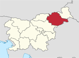
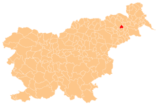
Orehova Vas
Location in Slovenia
Coordinates: 46°28′17.68″N15°39′58.35″E / 46.4715778°N 15.6662083°E / 46.4715778; 15.6662083 Coordinates: 46°28′17.68″N15°39′58.35″E / 46.4715778°N 15.6662083°E / 46.4715778; 15.6662083
Country Flag of Slovenia.svg Slovenia
Traditional region Styria
Statistical region Drava
Municipality Hoče–Slivnica
Area
  Total 2.71 km2 (1.05 sq mi)
Elevation 268 m (879 ft)
Population (2002)
  Total 381
[1]

Orehova Vas (pronounced  [ɔˈɾeːxɔʋa ˈʋaːs] ; Slovene : Orehova vas) is a settlement in the Municipality of Hoče–Slivnica in northeastern Slovenia. It lies on the edge of the flatlands on the right bank of the Drava River south of Maribor. The area is part of the traditional region of Styria. The municipality is now included in the Drava Statistical Region. [2]

Slovene language language spoken in Slovenia

Slovene or Slovenian belongs to the group of South Slavic languages. It is spoken by approximately 2.5 million speakers worldwide, the majority of whom live in Slovenia. It is the first language of about 2.1 million Slovenian people and is one of the 24 official and working languages of the European Union.

Slovenia republic in Central Europe

Slovenia, officially the Republic of Slovenia, is a sovereign state located in southern Central Europe at a crossroads of important European cultural and trade routes. It is bordered by Italy to the west, Austria to the north, Hungary to the northeast, Croatia to the southeast, and the Adriatic Sea to the southwest. It covers 20,273 square kilometers (7,827 sq mi) and has a population of 2.07 million. One of the successor states of the former Yugoslavia, Slovenia is a parliamentary republic and a member of the United Nations, of the European Union, and of NATO. The capital and largest city is Ljubljana.

Drava river in Italy, Austria, Slovenia, Croatia and Hungary

The Drava or Drave is a river in southern Central Europe. With a length of 710 kilometres (440 mi), 724 kilometres (450 mi) including the Sextner Bach source, it is the fifth or sixth longest tributary of the Danube, after the Tisza, Sava, Prut, Mureș and perhaps Siret. Its source is near the market town of Innichen, in the Puster Valley of South Tyrol, Italy. The river flows eastwards through East Tirol and Carinthia in Austria into the Styria region of Slovenia. It then turns southeast, passing through Croatia and, after merging with its main tributary Mur, forms most of the border between Croatia and Hungary, before it joins the Danube near Osijek.

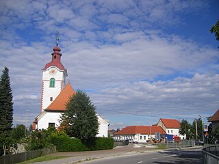
A chapel-shrine in the village dates to the early 20th century. [3]

Wayside shrine religious image, usually in some sort of small shelter, placed by a road or pathway

A wayside shrine is a religious image, usually in some sort of small shelter, placed by a road or pathway, sometimes in a settlement or at a crossroads, but often in the middle of an empty stretch of country road, or at the top of a hill or mountain. They have been a feature of many cultures, including Catholic and Orthodox Europe and Shinto Japan.

The terminal building and much of the runway of Maribor Edvard Rusjan Airport is located at Orehova Vas. [4]

Airport terminal airport facility where passengers move between air and ground transportation vessels

An airport terminal is a building at an airport where passengers transfer between ground transportation and the facilities that allow them to board and disembark from an aircraft.

Runway Area of surface used by aircraft to takeoff from and land on

According to the International Civil Aviation Organization (ICAO), a runway is a "defined rectangular area on a land aerodrome prepared for the landing and takeoff of aircraft". Runways may be a man-made surface or a natural surface.

Maribor Edvard Rusjan Airport airport

Maribor Edvard Rusjan Airport is an international airport in Maribor, Slovenia. The second biggest and second most important Slovenian airport, it is the only other airport besides the airport in Ljubljana suitable for international commercial aviation, equipped with ILS. At this location, the airport Skoke has been for sports purposes since 1953, and in 1976 it was complemented for international traffic. It is located in Hoče–Slivnica which is about 10 km (6.2 mi) south from Maribor. In 2008 it was renamed after the Slovene pioneer aviator Edvard Rusjan. The oldest Slovene aeroclub: Letalski center Maribor establish in 1927 also operates as one of the founders at the airport. In recent years this airport has become a popular place for training for many European airlines.

Related Research Articles

Municipality of Rače-Fram Municipality in Slovenia

The Municipality of Rače–Fram is a municipality south of Maribor in northeastern Slovenia. Its administrative centre is the settlement of Rače. The area was traditionally was part of the Styria region. It is now included in the Drava Statistical Region. The municipality covers an area of 52 square kilometres (20 sq mi) and extends from the plain on the right bank of the Drava River into the Pohorje Hills. The Ljubljana–Maribor motorway and railway line run through the municipality.

Municipality of Duplek Municipality in Slovenia

The Municipality of Duplek is a small municipality in northeastern Slovenia. Its administrative centre is Spodnji Duplek. The municipality lies on the left bank of the Drava River on the northwestern edge of the Slovene Hills, about 10 km southeast of Maribor. The area was part of the traditional region of Styria. It is now included in the Drava Statistical Region.

Trnovska Vas Place in Styria, Slovenia

Trnovska Vas is a settlement in the Municipality of Trnovska Vas in northeastern Slovenia. It is the seat of the municipality. The area was part of the traditional region of Styria. It is now included in the Drava Statistical Region. The settlement lies on the regional road from Ptuj to Lenart v Slovenskih Goricah in the Pesnica Valley.

Municipality of Hoče-Slivnica Municipality in Slovenia

The Municipality of Hoče–Slivnica is a municipality south of Maribor in northeastern Slovenia. Its administrative centre is in Spodnje Hoče.

Drava Statistical Region Statistical region

The Drava Statistical Region is a statistical region in Slovenia. The largest town in the region is Maribor. Its name comes from the Drava River and includes land on both banks along its course through Slovenia as well as the Pohorje mountains in the northeast of the region. The Drava is used for the production of hydroelectricity and the fertile land around it is used for agriculture. The share of job vacancies in all available jobs is among the highest in Slovenia and the region has a positive net migration rate but a very high natural decrease, which means an overall decrease in the population.

Čadramska Vas Place in Styria, Slovenia

Čadramska Vas is a village in the Municipality of Poljčane in northeastern Slovenia. It lies on the left bank of the Dravinja River, just west of the town of Poljčane. The main railway line from Ljubljana to Maribor runs through the settlement. The area is part of the traditional region of Styria. It is now included with the rest of the municipality in the Drava Statistical Region.

Dobrovce in Styria, Slovenia

Dobrovce is a village in the Municipality of Miklavž na Dravskem Polju in northeastern Slovenia. It lies on the right bank of the Drava River southeast of Maribor. The area is part of the traditional region of Styria. The municipality is now included in the Drava Statistical Region.

Spodnje Hoče Place in Styria, Slovenia

Spodnje Hoče is a settlement in and the administrative centre of the Municipality of Hoče–Slivnica in northeastern Slovenia. It lies below the eastern Pohorje Hills on the edge of the flatlands on the right bank of the Drava River south of Maribor. The area is part of the traditional region of Styria. The municipality is now included in the Drava Statistical Region.

Slivnica pri Mariboru Place in Styria, Slovenia

Slivnica pri Mariboru is a settlement in the Municipality of Hoče–Slivnica in northeastern Slovenia. It lies under the eastern Pohorje Hills on the edge of the flatlands on the right bank of the Drava River south of Maribor. The A1 Motorway runs through the settlement and a major interchange with the A4 motorway is located just north of the settlement. The area is part of the traditional region of Lower Styria. The municipality is now included in the Drava Statistical Region.

Bohova, Hoče–Slivnica Place in Styria, Slovenia

Bohova is a settlement in the Municipality of Hoče–Slivnica south of Maribor in northeastern Slovenia. The area is part of the traditional region of Styria. The municipality is now included in the Drava Statistical Region.

Čreta, Hoče–Slivnica Place in Styria, Slovenia

Čreta is a settlement in the Municipality of Hoče–Slivnica in northeastern Slovenia. It lies in the eastern foothills of the Pohorje Hills south of Maribor. The area is part of the traditional region of Styria. The municipality is now included in the Drava Statistical Region.

Hočko Pohorje Place in Styria, Slovenia

Hočko Pohorje is a settlement in the Municipality of Hoče-Slivnica in northeastern Slovenia. It lies in the eastern Pohorje Hills south of Maribor. The area is part of the traditional region of Styria. The municipality is now included in the Drava Statistical Region.

Hotinja Vas Place in Styria, Slovenia

Hotinja Vas is a village in the Municipality of Hoče–Slivnica in northeastern Slovenia. It lies on the edge of the flatlands on the right bank of the Drava River south of Maribor. Traditionally the area was part of the Styria region. The municipality is now included in the Drava Statistical Region.

Pivola Place in Styria, Slovenia

Pivola is a settlement in the Municipality of Hoče–Slivnica in northeastern Slovenia. It lies on the eastern edge of the Pohorje Hills south of Maribor. The municipality is now included in the Drava Statistical Region.

Polana, Hoče–Slivnica Place in Styria, Slovenia

Polana is a settlement in the Municipality of Hoče–Slivnica in northeastern Slovenia. It lies in the eastern part of the Pohorje Hills. The area is part of the traditional region of Styria. The municipality is now included in the Drava Statistical Region.

Radizel Place in Styria, Slovenia

Radizel is a settlement in the Municipality of Hoče–Slivnica in northeastern Slovenia. It lies at the eastern foothills of the Pohorje range south of Maribor. Traditionally the area was part of Styria. The entire municipality is now included in the Drava Statistical Region.

Rogoza Place in Styria, Slovenia

Rogoza is a settlement in the Municipality of Hoče–Slivnica in northeastern Slovenia. It lies on the flatlands on the right bank of the Drava River between Spodnje Hoče and Miklavž na Dravskem Polju. The area is part of the traditional region of Styria. The municipality is now included in the Drava Statistical Region.

Slivniško Pohorje Place in Styria, Slovenia

Slivniško Pohorje is a settlement in the Pohorje Hills south of Maribor in northeastern Slovenia. It lies in the Municipality of Hoče–Slivnica, part of the traditional region of Styria. The municipality is now included in the Drava Statistical Region.

Zgornje Hoče in Styria, Slovenia

Zgornje Hoče is a settlement in the Municipality of Hoče–Slivnica in northeastern Slovenia. It lies at the eastern foothills of the Pohorje range south of Maribor. The area is part of the traditional region of Styria. The municipality is now included in the Drava Statistical Region.

Municipality of Trnovska Vas Municipality in Slovenia

The Municipality of Trnovska Vas is a municipality in northeastern Slovenia. The seat of the municipality is the settlement of Trnovska Vas. The area was part of the traditional region of Styria. It is now included in the Drava Statistical Region.

References