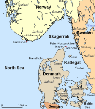
The Kattegat is a 30,000 km2 (12,000 sq mi) sea area bounded by the Jutlandic peninsula in the west, the Danish straits islands of Denmark and the Baltic Sea to the south and the provinces of Bohuslän, Västergötland, Halland and Skåne in Sweden in the east. The Baltic Sea drains into the Kattegat through the Danish straits. The sea area is a continuation of the Skagerrak and may be seen as a bay of the North Sea and North Atlantic Ocean, but in traditional Scandinavian usage, this is not the case.

Oland is a small hallig of the North Frisian Islands which is connected by a narrow-gauge railway to the mainland and to hallig Langeneß. In 2019, the population was estimated, unofficially, to be 16 people.

Flensburg Firth or Flensborg Fjord is the westernmost inlet of the Baltic Sea. It forms part of the border between Germany to the south and Denmark to the north, on the eastern side of Schleswig Holstein and Jutland, respectively. Its length is between 40 and 50 km, depending on where it is considered to begin. It has the largest area of all the fjords of East Jutland, which are a special type of inlet, different from geological fjords.

The Bay of Mecklenburg, also known as the Mecklenburg Bay or Mecklenburg Bight, is a long narrow basin making up the southwestern finger-like arm of the Baltic Sea, between the shores of Germany to the south and the Danish islands of Lolland, Falster, and Møn to the north, the shores of Jutland to the west, and joining the largest part of the Baltic to the east.

The Bay of Kiel or Kiel Bay is a bay in the southwestern Baltic Sea, off the shores of Schleswig-Holstein in Germany and the islands of Denmark. It is connected with the Bay of Mecklenburg in the east, the Little Belt in the northwest, and the Great Belt in the North.

Eiderstedt is a peninsula in the district of Nordfriesland in the German federal state of Schleswig-Holstein.
CKGA is an AM radio station in Gander, Newfoundland and Labrador, Canada, broadcasting on 650 kHz. Owned by Stingray Group, CKGA first went on the air in 1969 on 730 kHz, but moved to 650 in 1988. It is an affiliate of VOCM.
Sandamu is a Local Government Area in Katsina State, Nigeria. Its headquarters is located in the town of Sandamu on the A2 highway in the north of the area at12°57′37″N8°21′44″E.
Kieler Förde is an inlet of the Baltic Sea, approximately 17 km (11 mi) long, on the eastern side of Schleswig-Holstein, Germany. Formed by glacial movement during the last ice age, it divides Danish Wold peninsula from Wagria. Like the other inlets of förde-type, geologically it is not a fjord. It originates at the Hörn in centre-city Kiel and merges into the Bay of Kiel.

European route E1 is a series of roads in Europe, part of the United Nations International E-road network, running from Larne, Northern Ireland to Seville, Spain. There is a sea crossing between Rosslare Harbour, in Ireland, and Ferrol, but no ferry service. The road also passes through Portugal – past the city of Porto, through the capital, Lisbon, and then south to the Algarve, passing Faro before reaching the Spanish border west of Huelva.
Óhíd is a village in Zala County, Hungary. It is located 10 km west of Sümeg and 25 north of Keszthely, the largest city at the shore of the Lake Balaton.
Hjelm is a small Danish unpopulated island located in the Kattegat 10 km (6 mi) south-east from Ebeltoft.

Hammeren Lighthouse is located on the Hammeren peninsula on the northwestern tip of the Danish island of Bornholm.
Rønne Lighthouse is located close to the waterfront in Rønne on the Danish island of Bornholm.
Gedser Odde on the island of Falster in the Baltic Sea is Denmark's southernmost point. The terminal moraine from Idestrup through Skelby to Gedser is part of the maximum glaciation line across Falster, from Orehoved to Gedser. Fronted by low cliffs, the ridge, 5–7 m (16–23 ft) high, continues underwater a further 18 km (11 mi) south-east to Gedser Rev. Sydstenen marks the southernmost point.
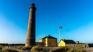
Skagen Lighthouse, also known as Skagen's Grey Lighthouse, is an active lighthouse four kilometres northeast of Skagen in the far north of Jutland, Denmark. Designed by architect Niels Sigfred Nebelong, it was brought into operation on 1 November 1858.

Fatuha Assembly constituency is one of 243 constituencies of legislative assembly of Bihar. It comes under Patna Sahib Lok Sabha constituency.

The Lightship Museum in the harbour of Esbjerg in southern Denmark consists of a private museum open to the public on board the Horns Rev lightship. Dating from 1912, the Horns Rev, also known as Motorfyrskibet Nr. I, is the world's oldest and best preserved motor lightship. It houses a highly regarded exhibition of life and work on board.
Gåbense Færgegård is a historic building in the village of Gåbense on the north coast of Falster in southeastern Denmark.

