
Palmerston North is a city in the North Island of New Zealand and the seat of the Manawatū-Whanganui region. Located in the eastern Manawatu Plains, the city is near the north bank of the Manawatu River, 35 km (22 mi) from the river's mouth, and 12 km (7 mi) from the end of the Manawatū Gorge, about 140 km (87 mi) north of the capital, Wellington. Palmerston North is the country's eighth-largest urban area, with an urban population of 81,200. The estimated population of Palmerston North city is 90,400.
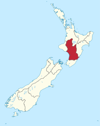
Manawatū-Whanganui is a region in the lower half of the North Island of New Zealand, whose main population centres are the cities of Palmerston North and Whanganui. It is administered by the Manawatū-Whanganui Regional Council, which operates under the name Horizons Regional Council.

Tangimoana is a community in the Manawatū-Whanganui Region of the North Island of New Zealand. It had a population of 303 permanent residents in 2018. It is located 15 kilometres southwest of Bulls, and 30 kilometres west of Palmerston North.

Manawatū District is a territorial authority district in the Manawatū-Whanganui local government region in the North Island of New Zealand, administered by Manawatū District Council. It includes most of the area between the Manawatū River in the south and the Rangitīkei River in the north, stretching from slightly south of the settlement of Himatangi in the south, to just south of Mangaweka in the north, and from the Rangitīkei River to the top of the Ruahine Range in the east. It does not include the Foxton area and the mouth of the Manawatū River, or Palmerston North City. Its main town is Feilding. The district has an area of 2,624 km².
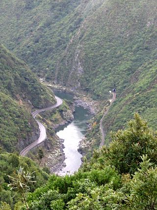
The Manawatū Gorge is a steep-sided gorge formed by the Manawatū River in the North Island of New Zealand. At 6 km (3.7 mi) long, the Manawatū Gorge divides the Ruahine and Tararua Ranges, linking the Manawatū and Tararua Districts. It lies to the northeast of Palmerston North. Its western end is near the small town of Ashhurst and its eastern end is close to the town of Woodville.

Feilding is a town in the Manawatū District of the North Island of New Zealand. It is located on State Highway 54, 20 kilometres north of Palmerston North. The town is the seat of the Manawatū District Council.

The Manawatū River is a major river of the lower North Island of New Zealand. The river flows from the Ruahine Ranges, through both the Manawatū Gorge and the city of Palmerston North, and across the Manawatū Plains to the Tasman Sea at Foxton.

Himatangi is a small settlement in the Manawatū-Whanganui region of New Zealand's North Island. It is located at the junction of State Highways 1 and 56, 25 kilometres west of Palmerston North, and seven kilometres east of the coastal settlement of Himatangi Beach.
Bunnythorpe is a village in the Manawatū-Whanganui region of New Zealand's North Island, 10 km (6 mi) north of the region's major city, Palmerston North. Dairy farms predominate the surrounding area but the community facilities include Bunnythorpe School, with a roll of about 80 pupils as of 2010 as well as a Rugby Football Club, Country Club and several manufacturing plants. The population was 687 in the 2018 census.

The Foxton Branch was a railway line in New Zealand. It began life as a tramway, reopened as a railway on 27 April 1876, and operated until 18 July 1959. At Himatangi there was a junction with the Sanson Tramway, a line operated by the Manawatu County Council that was never upgraded to the status of a railway.
Turitea is a suburb of Palmerston North in the Manawatū-Whanganui region of New Zealand. It is located on the southern side of the Manawatu River, south of Massey University.

The Oroua River is a river of the southwestern North Island of New Zealand.

Fitzherbert Park is a cricket ground in Palmerston North in New Zealand, a home ground of the Central Districts. In February 2000, New Zealand Women defeated England Women at the ground.

Lake Alice is an area located in the southwestern part of Rangitikei District of the Manawatū-Whanganui region of New Zealand's North Island. According to the 2013 census, it had a population of 2,724 inhabitants.
Rongotea is a small rural village in the Manawatū District of the Manawatū-Whanganui region. Located on the western Manawatū Plains, approximately 19 km (12 mi) northwest of the region's main city, Palmerston North.
The Mayor of Manawatu officiates over the Manawatū District of New Zealand.

Aorangi railway station was a small station on the North Island Main Trunk in New Zealand.
State Highway 54 (SH 54) is a New Zealand state highway nearly all in the Manawatū District in the North Island. It runs from SH 1 at Vinegar Hill to SH 3 near Palmerston North. The highway connects the Manawatū District's chief town, Feilding, to the New Zealand state highway network and forms an alternative route to SH 1 and SH 3 between the North Island Volcanic Plateau and Palmerston North.

MidCentral District Health Board was a district health board that provided healthcare in the Manawatū region of New Zealand. The DHB covers the Manawatū District, Palmerston North City, Tararua District, Horowhenua District, and the Ōtaki ward of the Kāpiti Coast District. In July 2022, the MidCentral DHB was merged into the national health service Te Whatu Ora.
Rangiotu is a farming community in the Manawatū District and Manawatū-Whanganui region in New Zealand's central North Island.
