Orrin H. Pilkey

Last updated
Orrin Pilkey
OPilkey R037.jpg
Orrin H. Pilkey
Born (1934-09-19) September 19, 1934 (age 89)
NationalityAmerican
Alma mater Florida State University
University of Montana
Washington State College
OccupationProfessor at Duke University

Orrin H. Pilkey (born September 19, 1934) is an American Professor Emeritus of Earth and Ocean Sciences, Nicholas School of the Environment, at Duke University, and founder and director emeritus of the Program for the Study of Developed Shorelines (PSDS) which is currently based at Western Carolina University. [1] [2] [3]

Contents

Life and career

Pilkey received his B.S. degree in geology at Washington State College, his M.S. degree in geology at the University of Montana and his Ph.D. degree in geology at Florida State University. Between 1962 and 1965, he was a research professor at the University of Georgia Marine Institute on Sapelo Island. [4] He has been at Duke University since 1965, with one year breaks with the Department of Marine Science at the University of Puerto Rico, Mayagüez, and with the U.S. Geological Survey in Woods Hole, Massachusetts.

Pilkey began his career with the study of abyssal plains on the deep sea floor. As a result of the destruction of his parents' house in Waveland, Mississippi in Hurricane Camille (1969), he switched to the study of coasts. Pilkey's research centers on both basic and applied coastal geology, focusing primarily on barrier island coasts and the effects of shoreline stabilization and development, and sea level rise. The PSDS has analyzed the numerical models used by coastal geologists and engineers to predict the movement of beach sand, especially in beach replenishment. In general, Pilkey argues that mathematical models cannot be used to accurately predict the behavior of beaches, although they can be useful if directional or orders-of-magnitude answers are sought. In the book, Useless Arithmetic, written with his daughter, Linda Pilkey-Jarvis, they argue that the outcome of natural processes in general cannot be accurately predicted by mathematical models. [5] The Rising Sea, written with Rob Young, current director of PSDS, focuses on the global threat from sea level rise. The Last Beach sounds the alarm that recreation on many of the world's beaches is going to be a thing of the past. It explains that "the future of the world's beaches hangs in the balance, from big threats such as engineering, mining, and pollution, to activities that seem harmless, like driving on beaches." In many places, pollution is in the beach sand as well as in the water. Retreat from a Rising Sea, written with daughter, Linda, and son, Keith, highlights the need for moving back from the coast, a process that is already beginning in some parts of the world, such as Arctic barrier islands, atolls, and river deltas. The authors think that New Orleans and Miami, among other cities, are doomed. His most recent book, Lessons from the Sand, offers easy experiments for kids (and adults)to do while learning about beach processes. Orrin co-wrote this colorful book which is completely illustrated by his son and co-author, Charles Pilkey, an artist/sculptor. [6]

Pilkey has received numerous awards, among them the Francis Parker Shepard medal for excellence in marine geology in 1987, [7] and in 2003, the Priestley Award, for distinguished research in coastal geology and public service in policy formulation and education about America's coastal resources, presented by Dickinson College, Pennsylvania. [8] In 1990, the North Carolina Wildlife Federation in cooperation with theNational Wildlife Federation, presenting Pilkey the Governor's Award, for Conservation Educator of the Year. Several others include: 1992, George V. Cohee Public Service Award, Eastern Section, AAPG, in recognition of the many accomplishments and untiring efforts in research and public education concerning the processes and geologic hazards in coastal zones, from The American Association of Petroleum Geologists; 1993, James H. Shea Award, for exceptional contributions in the form of writing and/or editing of Earth Science materials, from the National Association of Geology Teachers; 1993, American Geological Institute Award, for outstanding contributions to the public understanding of geology, for developing the 20-volume book series, Living with the Shore (with William Neal); and in 2001, he received the Honorary Doctor of Science Degree, University of the South (Sewanee), Sewanee, Tennessee. In 2012, Duke University honored Pilkey by naming a new research building for him at the Duke Marine Laboratory, Beaufort, North Carolina. [9]

Pilkey has published more than 250 technical publications and 45 books and has appeared in several documentary films (see below).

Publications

Books

  • Pilkey, C.O., and O.H. Pilkey. 2016. Lessons from the Sand: Family-Friendly Science Activities You Can Do On A Carolina Beach. Chapel Hill, NC: University of North Carolina Press. 221 pages. [10]
  • Pilkey, O.H., L. Pilkey-Jarvis, and K.C. Pilkey. 2016. Retreat from a Rising Sea: Hard Choices in an Age of Climate Change. New York: Columbia University Press. 214 pages. [11]
  • Pilkey, O.H., and J.A.G. Cooper. 2014. The Last Beach. Durham, NC: Duke University Press. 264 pages. ISBN   978-0-8223-5809-1 [12]
  • Cooper, J.A.G., and O.H. Pilkey (eds.). 2012. Pitfalls of Shoreline Stabilization: Selected Case Studies. New York: Springer. 333 pages.
  • Pilkey, O.H., W.J. Neal, J.T. Kelley, J.A.G. Cooper. 2011. The World's Beaches: A Global Guide to the Science of the Shoreline. Berkeley, CA: University of California Press. 283 pages. [13]
  • Pilkey, O.H., and K.C. Pilkey. 2011. Global Climate Change: A Primer. Durham, NC: Duke University Press. 142 pages. ISBN   978-0-8223-5109-2
  • Kelley, J.T., O.H. Pilkey, and J.A.G. Cooper (eds.), 2009. America's Most Vulnerable Coastal Communities. Geological Society of America Special Paper 460, 179 pages.
  • Pilkey, O.H., and R. Young. 2009. The Rising Sea. Washington, D.C.: Island Press. 203 pages. ISBN   978-1-59726-191-3 [14]
  • Neal, W.J., O.H. Pilkey, and J.T. Kelley. 2007. Atlantic Coast Beaches: A Guide to Ripples, Dunes, and Other Natural Features of the Seashore. Missoula, MT: Mountain Press Publishing Company. 272 pages. [15]
  • Pilkey, O.H., and L. Pilkey-Jarvis. 2007. Useless Arithmetic: Why Environmental Scientists Can’t Predict the Future. New York: Columbia University Press. 230 pages. ISBN   978-0-231-13213-8 [16]
  • Pilkey, O.H., T.M. Rice, and W.J. Neal. 2004. How to Read a North Carolina Beach. Chapel Hill, NC: University of North Carolina Press. 162 pages. ISBN   978-0-8078-5510-2 [17]
  • Pilkey, O.H., and M.E. Fraser. 2003. A Celebration of the World's Barrier Islands. New York: Columbia University Press. 309 pages.
  • Bush, D.M., O.H. Pilkey, and W.J. Neal. 1996. Living by the Rules of the Sea. Durham, NC: Duke University Press. 179 pages.
  • Pilkey, O.H., and K.L. Dixon. 1996. The Corps and the Shore. Washington, D.C.: Island Press. 272 pages. [18]
  • Finkl, C., and O.H. Pilkey (eds.), 1991. The Impacts of Hurricane Hugo. Sept. 10–22, 1989. Journal of Coastal Research Special Issue #8.
  • Kraus, N.C., and O.H. Pilkey (eds.), 1988. The Effects of Seawalls on the Beach. Journal of Coastal Research Special Issue #4, 146 pages.
  • Nummedal, D., O.H. Pilkey, and J.D. Howard (eds.), 1987. Sea Level Rise and Coastal Evolution (Armstrong Price Symposium). Society of Economic Paleontologists and Mineralogists Special Publication #41, 266 pages.
  • Pilkey, O.H. Sr., W.D. Pilkey, O.H. Pilkey Jr., and W.J. Neal, 1984. Coastal Design, A Guide for Planners, Developers and Homeowners. New York: Van Nostrand Reinhold, 224 pages.
  • Kaufman, W., and O.H. Pilkey. 1979. The Beaches Are Moving: The Drowning of America's Shoreline. Anchor Doubleday, 326 pages. (Book of the Month Club Alternate Selection, 1980). Paperback edition (1983), Durham, NC: Duke University Press. 336 pages. [19]
  • Pilkey, O.H., W.J. Neal, and O.H. Pilkey Sr., 1978. From Currituck to Calabash. Raleigh, NC: N.C. Science and Technology Research Center, 228 pages. 2nd edition, 191 pages. 3rd edition, Durham, NC: Duke University Press.
  • Pilkey, O.H., and S.J. Fritz (eds.), 1976. A Marine Atlas of Puerto Rico. San German, Puerto Rico: M.J. Cerame VIVAS, Inc., 139 pages.
  • Pilkey, O.H., O.H. Pilkey Sr., and R. Turner, 1975. How to Live With an Island. Raleigh, NC: Dept. of Natural and Economic Resources, 191 pages.
  • Swift, D.J.P., D.B. Duane, and O.H. Pilkey (eds.), 1972. Shelf Sediment Transport, Process and Pattern. Stroudsburg, PA: Dowden, Hutchinson and Ross, Inc., 656 pages.
  • Newton, J.G., O.H. Pilkey, and J.O. Blanton, 1971. An Oceanographic Atlas of the Carolina Continental Margin. N.C. Dept. of Conservation and Development, 57 pages.

Selected articles

  • Neal, W.J., O.H. Pilkey, J.A.G. Cooper, and N.J. Longo, 2017. "Why Coastal Regulations Fail." Ocean & Coastal Management. xxx: 1–14.
  • Pilkey, O.H., and J.A.G. Cooper, 2014. "Are Natural Beaches Facing Extinction?" In: Green, A.N. and J.A.G. Cooper (eds.), Proceedings 13th International Coastal Symposium (Durban, South Africa). Journal of Coastal Research Special Issue No. 70, pp. 431–436. Coconut Creek (Florida), ISSN 0749-0208.
  • Glass, A., and O.H. Pilkey, March 2013. "Denying Sea-Level Rise. How 100 Centimeters Divided the State of North Carolina." American Geosciences Institute. EARTH Magazine, pp. 26–33.
  • Pilkey, O.H., R. Young, and J.A.G. Cooper, 2013. "Quantitative modeling of coastal processes. A boom or a bust for society?" In Baker, V.R. (ed.), Rethinking the Fabric of Geology (125th Anniversary Volume). Geological Society of America Special Paper 502, pp. 135–144.
  • Pilkey, O.H., Jan. 2012. "What Do You Do When the Models Get It Wrong?" American Geosciences Institute. EARTH Magazine, p. 70.
  • Pilkey, O.H., R. Young, A. Coburn, and N.J. Longo. 2012. "Rethinking Living Shorelines." [20]
  • Stutz, M.L., and O.H. Pilkey. 2011. "Open-ocean Barrier Islands: Global Influence of Climatic, Oceanographic, and Depositional Settings." Journal of Coastal Research 27(2):207–222.
  • Pilkey, O.H., J.A.G. Cooper, and D.A. Lewis. 2009. "Global distribution and geomorphology of fetch-limited barrier islands." Journal of Coastal Research 25(4):819–837.
  • Thieler, E.R., et al. 2000. "The Use of Mathematical Models to Predict Beach Behavior for U.S. Coastal Engineering: A Critical Review." Journal of Coastal Research 16(1):48-70.

Documentaries and videos

Related Research Articles

<span class="mw-page-title-main">Coastal erosion</span> Displacement of land along the coastline

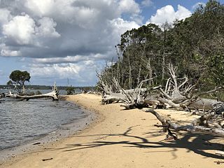
Coastal erosion is the loss or displacement of land, or the long-term removal of sediment and rocks along the coastline due to the action of waves, currents, tides, wind-driven water, waterborne ice, or other impacts of storms. The landward retreat of the shoreline can be measured and described over a temporal scale of tides, seasons, and other short-term cyclic processes. Coastal erosion may be caused by hydraulic action, abrasion, impact and corrosion by wind and water, and other forces, natural or unnatural.

<span class="mw-page-title-main">Singing sand</span> A phenomenon of sand that produces sound

Singing sand, also called whistling sand, barking sand or singing dune, is sand that produces sound. The sound emission may be caused by wind passing over dunes or by walking on the sand.

<span class="mw-page-title-main">Tombolo</span> Deposition landform in which an island is connected to the mainland by a sandy isthmus

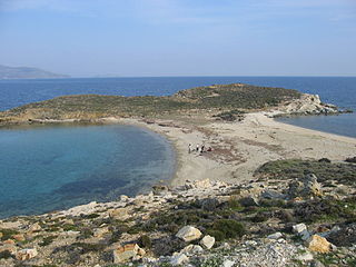
A tombolo is a sandy or shingle isthmus. A tombolo, from the Italian tombolo, meaning 'pillow' or 'cushion', and sometimes translated incorrectly as ayre, is a deposition landform by which an island becomes attached to the mainland by a narrow piece of land such as a spit or bar. Once attached, the island is then known as a tied island.

<span class="mw-page-title-main">Longshore drift</span> Sediment moved by the longshore current

Longshore drift from longshore current is a geological process that consists of the transportation of sediments along a coast parallel to the shoreline, which is dependent on the angle of incoming wave direction. Oblique incoming wind squeezes water along the coast, and so generates a water current which moves parallel to the coast. Longshore drift is simply the sediment moved by the longshore current. This current and sediment movement occur within the surf zone. The process is also known as littoral drift.

<span class="mw-page-title-main">Barrier island</span> Coastal dune landform that forms by wave and tidal action parallel to the mainland coast

Barrier islands are a coastal landform—a type of dune system and sand island—where an area of sand has been formed by wave and tidal action parallel to the mainland coast. They usually occur in chains, consisting of anything from a few islands to more than a dozen. They are subject to change during storms and other action, but absorb energy and protect the coastlines and create areas of protected waters where wetlands may flourish. A barrier chain may extend for hundreds of kilometers, with islands periodically separated by tidal inlets. The largest barrier island in the world is Padre Island of Texas, United States, at 113 miles (182 km) long. Sometimes an important inlet may close permanently, transforming an island into a peninsula, thus creating a barrier peninsula, often including a beach, barrier beach. Though many are long and narrow, the length and width of barriers and overall morphology of barrier coasts are related to parameters including tidal range, wave energy, sediment supply, sea-level trends, and basement controls. The amount of vegetation on the barrier has a large impact on the height and evolution of the island.

<span class="mw-page-title-main">Beach nourishment</span> Sediment replacement process

Beach nourishment describes a process by which sediment, usually sand, lost through longshore drift or erosion is replaced from other sources. A wider beach can reduce storm damage to coastal structures by dissipating energy across the surf zone, protecting upland structures and infrastructure from storm surges, tsunamis and unusually high tides. Beach nourishment is typically part of a larger integrated coastal zone management aimed at coastal defense. Nourishment is typically a repetitive process since it does not remove the physical forces that cause erosion but simply mitigates their effects.

<span class="mw-page-title-main">Nicholas School of the Environment</span>

The Nicholas School of the Environment is one of ten graduate and professional schools at Duke University and is headquartered on Duke’s main campus in Durham, N.C. A secondary coastal facility, Duke University Marine Laboratory, is maintained in Beaufort, North Carolina. The Nicholas School is composed of three research divisions: Earth and Climate Sciences, Environmental Sciences and Policy, and Marine Science and Conservation. The current dean of the Nicholas School is Toddi Steelman.

<span class="mw-page-title-main">Coastal management</span> Preventing flooding and erosion of shorelines

Coastal management is defence against flooding and erosion, and techniques that stop erosion to claim lands. Protection against rising sea levels in the 21st century is crucial, as sea level rise accelerates due to climate change. Changes in sea level damage beaches and coastal systems are expected to rise at an increasing rate, causing coastal sediments to be disturbed by tidal energy.

Stephen Parker Leatherman, also known as Dr. Beach, is an American geoscientist, coastal ecologist, and author. He was the first director of the International Hurricane Research Center at Florida International University (FIU), from 1997 to 2009. He then became professor and co-director of the Laboratory for Coastal Research at FIU. Leatherman often discuss his research on beach quality evaluations, beach erosion, coastal storm and sea level rise impacts and rip currents.

<span class="mw-page-title-main">Bogue Banks</span> Barrier island off of North Carolina

Bogue Banks form a 21-mile (34 km) barrier island off the mainland of North Carolina in Carteret County. The island, separated from the mainland by Bogue Sound, runs east to west, with the ocean beaches facing due south. Bogue Banks is the only island on the Carteret County shore that has been developed with housing: numerous communities are located on the island and can be accessed by one of two bridges across Bogue Sound, either from Morehead City to Atlantic Beach, which is the more heavily traveled bridge, or from Cape Carteret to Emerald Isle. The communities of Bogue Banks are the most prominent of the Crystal Coast. NC 58 traverses a majority of the island's length. There are several hotels that dot the island, but most of the land contains private houses, some of which are rented out during the summer, or maritime forest. Stores and other commercial properties are limited to the five main communities.

<span class="mw-page-title-main">Bird Island, North Carolina</span>

Bird Island is approximately 1,300 acres (5.3 km2) adjacent to the town of Sunset Beach, North Carolina, US. Sunset Beach is on a barrier island and is the southernmost town in North Carolina. Bird Island can be reached by walking along the seashore toward the South Carolina border. Due to the contour of the Atlantic Coast at this point, the direction of travel to Bird Island is approximately West-Southwest. Previously, Bird Island was separated from Sunset Beach by a tidal creek that could be easily crossed only at low tide. Accretion of ocean sand has gradually filled in the tidal creek so that two separate islands became one.

<span class="mw-page-title-main">Coastal engineering</span> Branch of civil engineering

Coastal engineering is a branch of civil engineering concerned with the specific demands posed by constructing at or near the coast, as well as the development of the coast itself.

Robert S. Young is professor of coastal geology at Western Carolina University and director of the Program for the Study of Developed Shorelines.

<span class="mw-page-title-main">American Shore and Beach Preservation Association</span> Non-profit organization

The American Shore and Beach Preservation Association (ASBPA) is a private, nonprofit organization formed in 1926. It was founded to address coastal erosion and the loss of sand on America's beaches. Today, ASBPA is an association of beach and coastal practitioners, including beach towns and managers, coastal engineers, coastal geologists, dredging and ecological restoration companies, coastal academics and students. ASBPA advances coastal science and coastal engineering through its peer-reviewed journal, Shore & Beach, and an annual technical conference. It also hosts an annual coastal summit in Washington, DC to advocate for coastal policies.

Cuchlaine Audrey Muriel King was a British geomorphologist known for her work in glaciology and her extensive writings on the geography of coasts and beaches. She, with John P Cole, was one of the first to produce a book on quantitative methods in geography.

<span class="mw-page-title-main">Sea Bright–Monmouth Beach Seawall</span> Seawall in New Jersey

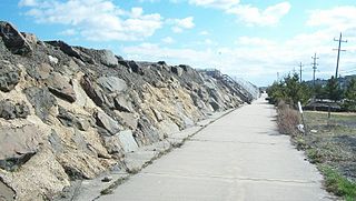
The Sea Bright–Monmouth Beach Seawall is a seawall located along the Jersey Shore in the Monmouth County, New Jersey towns of Sea Bright and Monmouth Beach. It roughly runs north-south direction along 4.7 miles (7.6 km) of the barrier spit of land along the lower Sandy Hook peninsula between the Atlantic Ocean and the Shrewsbury River estuary. The use of seawalls, groins, jetties, bulkheads, revetment, and beach nourishment since the late 1800s has made the stretch of coast one of the most heavily engineered sections of ocean shorefront in the world.

<span class="mw-page-title-main">Sand wave</span> Sedimentary structure formed by aeolian processes or the flow of water

A sand wave is a lower regime sedimentary structure that forms across from tidal currents.

<span class="mw-page-title-main">Duke University Marine Laboratory</span> Research facility and campus of Duke University on Pivers Island

The Duke University Marine Laboratory is a research facility and campus of Duke University on Piver's Island, near Beaufort and the Outer Banks, North Carolina specializing in studying marine biology. It is part of the Nicholas School of the Environment's Division of Marine Science and Conservation.

<span class="mw-page-title-main">Bruun rule</span> Formula for estimating the magnitude of shoreline retreat due to changes in sea level

The Bruun rule is a formula for estimating the magnitude of the retreat of the shoreline of a sandy shore in response to changes in sea level. Originally published in 1962 by Per Bruun, the Bruun rule was the first to give a relationship between sea level rise and shoreline recession. The rule is a simple, two dimensional mass conversion, and remains in common use to estimate shoreline recession in response to sea level rise, despite criticism and modification, and the availability of more complex alternate models.

<span class="mw-page-title-main">Beaches in estuaries and bays</span> Type of beaches

Beaches in estuaries and bays (BEBs) refer to beaches that exist inside estuaries or bays and therefore are partially or fully sheltered from ocean wind waves, which are a typical source of energy to build beaches. Beaches located inside harbours and lagoons are also considered BEBs. BEBs can be unvegetated or partially unvegetated and can be made of sand, gravel or shells. As a consequence of the sheltering, the importance of other sources of wave energy, including locally generated wind waves and infragravity waves, may be more important for BEBs than for those beaches on the open coast. Boat wakes, currents driven by tides, and river inflow can also be important for BEBs. When BEBs receive insufficient wave energy, they can become inactive, and stabilised by vegetation; this may occur through both natural processes and human action. BEBs exist in all latitudes from beaches located in fjords and drowned river valleys (rias) in high latitudes to beaches located in the equatorial zone like, for example, the Amazon estuarine beaches.

References

  1. "Orrin Pilkey, Director Emeritus". Psds.wcu.edu. 29 March 2014. Retrieved 16 October 2018.
  2. "Orrin H. Pilkey, shoreline expert, answers questions,"
  3. "Orrin H. Pilkey, shoreline expert, answers questions". Grist.org. 26 September 2006. Retrieved 16 October 2018.
  4. Collier, Barnard L. (1988-12-04). "Crusader on the Beach". The New York Times. Retrieved 16 October 2018.
  5. "Book Assails Unrealistic Mathematical Models". Today.duke.edu. 25 January 2007. Retrieved 16 October 2018.
  6. "index". Charlespilkey.com. Retrieved 16 October 2018.
  7. "SEPM - Past Winners". Sepm.org. Retrieved 16 October 2018.
  8. Pearlstein, Max. "Dickinson Awards". Dickinson.edu. Retrieved 16 October 2018.
  9. "Orrin Pilkey Laboratory - Nicholas School". Nicholas.duke.edu. Retrieved 16 October 2018.
  10. "Lessons from the Sand - Charles O. Pilkey - University of North Carolina Press". Uncpress.unc.edu. Retrieved 16 October 2018.
  11. Retreat from a Rising Sea - Columbia University Press. Columbia University Press. May 2016. ISBN   9780231541800 . Retrieved 16 October 2018.{{cite book}}: |website= ignored (help)
  12. "The Last Beach". Dukeupress.edu. Retrieved 16 October 2018.
  13. The World's Beaches . Retrieved 16 October 2018.{{cite book}}: |website= ignored (help)
  14. "The Rising Sea". Islandpress.org. 9 July 2015. Retrieved 16 October 2018.
  15. "Mountain Press Publishing Company". Mountain-press.com. Archived from the original on 17 October 2018. Retrieved 16 October 2018.
  16. Useless Arithmetic - Columbia University Press. Columbia University Press. January 2007. ISBN   9780231506991 . Retrieved 16 October 2018.{{cite book}}: |website= ignored (help)
  17. "How to Read a North Carolina Beach - Orrin H. Pilkey - University of North Carolina Press". Uncpress.unc.edu. Retrieved 16 October 2018.
  18. [ dead link ]
  19. "The Beaches Are Moving". Dukeupress.edu. Retrieved 16 October 2018.
  20. "Rethinking Living Shorelines" (PDF). Wcu.edu. Retrieved 16 October 2018.
  21. "SAND WARS". Sand-wars.com. Retrieved 16 October 2018.
  22. "Shored Up - Home Page". Shoredupmovie.com. Retrieved 16 October 2018.