Ortoire (village)

Last updated
Ortoire
Village/Municipal Corporation
Trinidad and Tobago adm location map.svg
Red pog.svg
Ortoire
Coordinates: 10°20′12″N60°59′44″W / 10.3366°N 60.9955°W / 10.3366; -60.9955 Coordinates: 10°20′12″N60°59′44″W / 10.3366°N 60.9955°W / 10.3366; -60.9955
Country Trinidad and Tobago
IslandTrinidad
County (historical) Mayaro
Region CorporationMayaro-Rio Claro
Population
 (2011)
  Total764

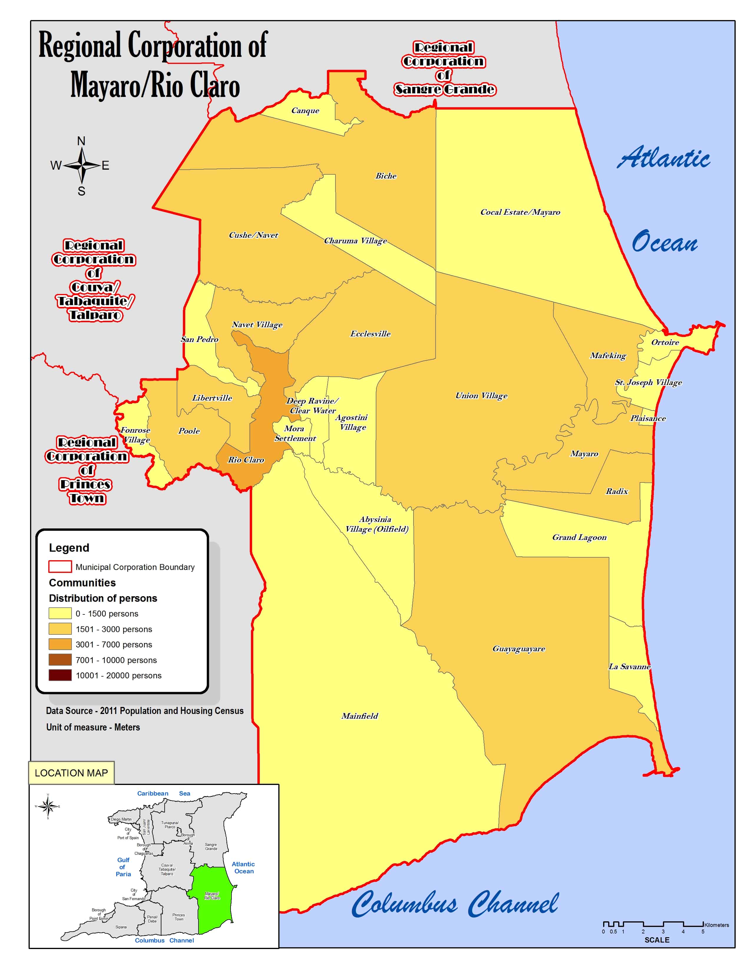
Ortoire is a village in Mayaro County on Trinidad Island. It is named after the adjacent Ortoire River. The village dates to at least the 1880s or a few decades earlier. Ortoire is just west of the peninsula of Point Radix, named after a French immigrant granted an estate there in 1783. The village's beach at the mouth of the river provides shelter to ocean-going fishing boats. The village was not listed in the 1901 census, but was believed to have "a few hundred people" then. [1] The village is within the Ortoire Municipal Corporation, a political subdivision of the Mayaro–Rio Claro Regional Corporation, a political region of Trinidad and Tobago that replaced the historical county of Mayaro in 1991. The Ortoire Municipal Corporation includes the Point Radix peninsula and is bounded by Mafeking on the west, St. Joseph Village on the south, and the Atlantic Ocean on the east and north. [2]

The population as of the 2011 census was 764, of which 375 were male, and 230 were under the age of 18. [3]

Related Research Articles

Port of Spain Capital of Trinidad and Tobago

Port of Spain, officially the City of Port of Spain, is the capital city of Trinidad and Tobago and the country's second-largest city after San Fernando and the third largest municipality after Chaguanas and San Fernando. The city has a municipal population of 37,074, an urban population of 81,142 and a transient daily population of 250,000. It is located on the Gulf of Paria, on the northwest coast of the island of Trinidad and is part of a larger conurbation stretching from Chaguaramas in the west to Arima in the east with an estimated population of 600,000.

Trinidad The larger of the two major islands which make up the nation of Trinidad and Tobago

Trinidad is the larger and more populous of the two major islands of Trinidad and Tobago. The island lies 11 km (6.8 mi) off the northeastern coast of Venezuela and sits on the continental shelf of South America. It is often referred to as the southernmost island in the Caribbean. With an area of 5,131 km2 (1,981 sq mi), it is also the fifth largest in the West Indies.

Mayaro County County on Trinidad island

Mayaro is the name of a county on southeastern Trinidad island, in Trinidad and Tobago.

Guayaguayare

Guayaguayare is the southeasternmost village in Trinidad and Tobago. It lies at the southern end of the county of Mayaro. Guayaguayare is primarily a fishing village, but it also plays a major role in the petroleum industry. The largest petroleum producers in the country - BP Trinidad & Tobago (bpTT), BHP Billiton and Petrotrin all have major presences here and bpTT controls the Port of Guayaguayare, which services most of the offshore petroleum production in Trinidad. The major natural gas pipelines, serving Atlantic LNG in Point Fortin and the Point Lisas Industrial Estate, come ashore here.

Rio Claro, Trinidad and Tobago

Rio Claro is the largest town in southeastern Trinidad, in Trinidad and Tobago. Rio Claro lies east of Princes Town, west of Mayaro and northwest of Guayaguayare. It serves as the major commercial centre for southeastern Trinidad. It lies in a primarily agricultural area. It is the seat of the Rio Claro–Mayaro Regional Corporation.

Nariva County

Nariva is a county in Trinidad and Tobago. It is located in eastern Trinidad, south of Saint Andrew County and north of Mayaro County, to the west by Victoria County and to the northwest by Saint George County. The southern boundary of the county lies along the Ortoire River and the western boundary is Cocos Bay. The towns of Rio Claro and Ecclesville are located in Nariva County. The Nariva Swamp is located in the eastern part of Nariva County.

Victoria was a county on Trinidad island in Trinidad and Tobago.

Couva–Tabaquite–Talparo Region

Couva–Tabaquite–Talparo is one of the nine regions of Trinidad and Tobago, and one of the five regions which form Gulf of Paria coastline on Trinidad's West Coast. Its regional capital and commercial center is Couva. Couva–Tabaquite–Talparo is the third-largest of Trinidad and Tobago's nine regions, with an area of 723 square kilometres (300 sq mi). As of 2011, the population was 178,410. The region is the second-most populous and fourth-least-densely populated region in Trinidad with 247 inhabitants per square kilometre (640/sq mi).

Mayaro–Rio Claro region of Trinidad, Trinidad and Tobago

Mayaro–Rio Claro is a region of Trinidad. The local government body is Mayaro–Rio Claro Regional Corporation, a Regional Corporation of Trinidad and Tobago. The region has a land area of 852.81 km2 (329.27 sq mi). The Mayaro–Rio Claro Regional Corporation is headquartered in Rio Claro. Other towns include Mayaro.

Biche Village in Trinidad and Tobago

Biche is a village in east Trinidad and Tobago 18 kilometers south of Sangre Grande and 18 kilometers north of Rio Claro.

Ortoire River River in Trinidad and Tobago

The Ortoire River is a river in Trinidad and Tobago. It forms the boundary between Nariva County and Mayaro County in east Trinidad.

The Public Transport Service Corporation or better known as PTSC is the state-owned public transport provider for Trinidad and Tobago. Its headquarters are at City Gate in Port of Spain. Passengers have to buy the tickets at a ticket booth and show it to the driver. The fares vary with distance. There are two type of buses: the blue-and-white buses are the regular and the red-and-white are the express commuter buses. The latter are more expensive, make fewer stops and are more comfortable.

Ortoire may refer to:

Index of Trinidad and Tobago–related articles wikimedia list article

The following is an alphabetical list of topics related to the Republic of Trinidad and Tobago.

Mayaro, Trinidad Town in Mayaro-Rio Claro, Trinidad and Tobago

Mayaro is a town in Mayaro County on the island of Trinidad in Trinidad and Tobago.

In 2012, the government of Trinidad and Tobago approved the introduction of postal codes starting later that same year. In addition to the postal code implementation the country has embarked on a nationwide address improvement initiative adopting the Universal Postal Union (UPU) S-42 international standard of addressing. The UPU is an arm of the United Nations and is the coordinating body of postal services worldwide. The intent of this exercise is to correct poor addressing in Trinidad & Tobago and assign to each address a six-digit postal code. This change will result in the following:

2019 Trinidadian local elections

Local elections in Trinidad and Tobago were held on 2 December 2019, contesting 139 electoral districts across Trinidad's 14 municipal corporation electoral areas.

References

  1. "Towns and Villages". nalis.gov.tt. National Library and Information System Authority. Retrieved December 16, 2020.
  2. Regional Corporation of Mayaro/Rio Claro (Map). Retrieved December 17, 2020.
  3. Demographic Profiles of Municipalities and Communities. cso.gov.tt (Report). Government of Trinidad & Tobago. Retrieved December 17, 2020.