Course
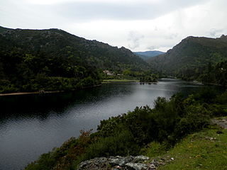
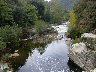
The Ortolo is 31.75 kilometres (19.73 mi) long. It crosses the communes of Levie, Foce and Sartène. [1] The river rises at an altitude of 1,225 metres (4,019 ft). Its source is in Levie on the southwest of the 1,314 metres (4,311 ft) Punta di a Vacca Morta. It flows in a generally southwest direction past the hamlet of Bilzese (Foce) to the border of the commune of Sartène where it is dammed to form the Ortolo Reservoir. Below the dam it continues to flow southeast to enter the sea to the southwest of Tizzano.
The D265 road leads east towards the river from the village of Bilzese. The D365 branches off after 2.5 kilometres (1.6 mi) and crosses the river by a metal bridge. From the bridge a footpath leads down to the river, where there are a few small natural swimming pools. There is a larger and deeper pool just below the bridge.
The Riverin River is a river in the Côte-Nord region of the province of Quebec, Canada. It is a tributary of the Gulf of Saint Lawrence. There is a small hydroelectric power plant near the mouth of the river.

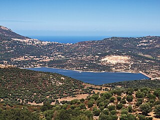
Alesani Reservoir or Alesani Lake is a reservoir in the Haute-Corse department of France formed in 1970 by damming the Alesani River with the Alesani Dam. It is the main source of irrigation water along the east coast of Haute-Corse, and it also supplies water for human consumption and hydroelectric power generation.

The Alesani River is a river in the Haute-Corse department in the island of Corsica, France.
The Sampolo Reservoir is a reservoir in the Haute-Corse department of Corsica, France. It is formed by damming the Fiumorbo river by the Barrage du Sampolo. The reservoir provides hydroelectricity and water for irrigation. The gallery of the dam is home to important bat colonies.
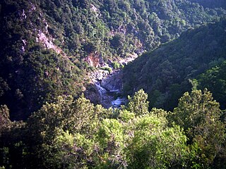
The Fiumorbo is a coastal river in the department of Haute-Corse, Corsica, France. It is dammed in two places to supply irrigation water and hydroelectricity. Between the two dams it runs through the spectacular Défilé de l’Inzecca, a Natura 2000 site.
Codole Reservoir is a reservoir in the Haute-Corse department of France, on the island of Corsica. It supplies water for drinking and irrigation. The reservoir and its immediate surroundings are important as a biotope that offers habitat for many species of birds, reptiles and amphibians

The Bravone is a small coastal river in the department of Haute-Corse, Corsica, France.
The Barrage de Corscia is a dam in the Haute-Corse department of France on the Golo river. It impounds an intermediate reservoir in the Golo hydroelectric complex. The Corscia hydroelectric power station fed by water channeled from Lac de Calacuccia has a capacity of 13 mW and discharges into the Corscia reservoir. Downstream from the Corscia reservoir there is another power station at Castirla.

The Alzitone Reservoir is a reservoir in the Haute-Corse department of France. It dams the Pedocchino stream, but most of the water is supplied from the Réservoir de Trévadine on the Fiumorbo river. It supplies water for drinking and for irrigation, which during the summer low water is delivered using a pumping station.

The Ortolo Reservoir is a reservoir in the Corse-du-Sud department of France on the island of Corsica.

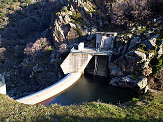
The Rizzanese Reservoir is a reservoir in the Corse-du-Sud department of France on the island of Corsica. It stores water for irrigation, and supplies the largest hydroelectric power plant in Corsica, with installed capacity of 55 MW.

The Ospedale Reservoir is a reservoir in the Corse-du-Sud department of France on the island of Corsica. It holds drinking water for the southeast of the island, including Porto-Vecchio. It is surrounded by a forest that has been designated a Zone naturelle d'intérêt écologique, faunistique et floristique (ZNIEFF).

The Figari Reservoir is a reservoir in the Corse-du-Sud department of France on the island of Corsica. It provides water for irrigation and human consumption.

The Lac de Tolla is a reservoir in the Corse-du-Sud department of France on the island of Corsica. It is the largest lake on Corsica, and powers a hydroelectric plant.
Bacciana Reservoir is a reservoir in the Haute-Corse department of France, on the island of Corsica. It supplies water for drinking and irrigation.

Teppe Rosse Reservoir is a reservoir in the Haute-Corse department of France, on the island of Corsica. It supplies water for drinking and irrigation.
Trévadine Reservoir is a reservoir in the Haute-Corse department of France, on the island of Corsica. It stores water for drinking and irrigation, which is fed to reservoirs in the coastal plain.
Peri Reservoir is a reservoir in the Haute-Corse department of France, on the island of Corsica. It supplies water for drinking and irrigation to the central section of the eastern plain of Corsica. In peak periods it also supplies water to the southern section.

The Prunelli is a small coastal river in the department of Corse-du-Sud, Corsica, France. It flows into the Golfe d'Ajaccio on the Mediterranean Sea.
The Rizzanese is a coastal river in the southwest of department of Corse-du-Sud, Corsica, France. It is dammed near Sorbollano to form the Rizzanese Reservoir, which stores water for irrigation and supplies the largest hydroelectric power plant in Corsica, with installed capacity of 55 MW. It flows into the Mediterranean Sea near the town of Propriano.
This page is based on this
Wikipedia article Text is available under the
CC BY-SA 4.0 license; additional terms may apply.
Images, videos and audio are available under their respective licenses.


