Liamone | |
---|---|
The mouth of Liamone at sunset | |
![]() Course of the Liamone | |
Location | |
Country | France |
Region | Corsica |
Physical characteristics | |
Source | Monte Cimatella |
• elevation | 1,850 m (6,070 ft) |
Mouth | Mediterranean Sea |
• coordinates | 42°04′41″N8°43′01″E / 42.078°N 8.7169°E Coordinates: 42°04′41″N8°43′01″E / 42.078°N 8.7169°E |
Length | 40.6 km (25.2 mi) |
The Liamone (Corsican : Liamonu, Latin : Circidius) river is a river of Corsica, France. The river gave its name to the former French department of Liamone. In antiquity, it bore the Latin name Circidius. [1]
The length of its course is 40.6 kilometres (25.2 mi), entirely within the French department of Corse-du-Sud. It flows through ten communes : Letia, Murzo, Vico, Rosazia, Arbori, Lopigna, Arro, Ambiegna, Coggia and Casaglione. [2] The Liamone has its source on the western slope of Monte Cimatella (2,099 meters (6,886 ft)), on the territory of the municipality of Letia, at an elevation of 1,850 meters (6,070 ft). [3] In its upper course, it forms a waterfall (called Piscia) between elevations 546 meters (1,791 ft) and 514 meters (1,686 ft). After a course of 40.9 kilometres (25.4 mi), it flows into the Gulf of Sagone north of Ajaccio, between the two towns of Coggia and Casaglione.
The Liamone gives its name to the Liamone landscape, an area of Corsica. It is the central watershed in this landscape, the others being the Sagone and Liscia rivers. These have created a large alluvial plain along the coast. [4] In the coastal plain the river makes wide meanders. [5] There are no permanent settlements in the plain, which is unhealthy, apart from a few farms. The only villages are below the ridge that separates the Liamone from the Cinarca to the south. The RD81 road runs along the seaside between beaches and wet meadows. [6]
Upstream the reliefs quickly become steep, with thick vegetation. The sea remains visible, although not the plain, until a high rock barrier below the Cruzinu tributary blocks the view. [5] The east side of the Liamone gorges, where it is followed by the RD4, is almost completely uninhabited. [6] The RD1 connecting Cinarca to Vico passes on the opposite side, less rugged and less wooded. [7]
Above the gorges the topography is less rugged and the land is more inhabited, with many villages surrounded by groves of olives and chestnuts. Above the slopes are covered in pine forest, maquis or grassland. The villages once had a large population secure from the dangers of the coast, and almost self-sufficient economically. [8] Today many of the inhabitants have left, but the fortified town of Vico with its tall houses and the Convent of Saint-François still preserve a strong architectural heritage. [9]
There is a legend that three brothers, Liamone, Golo and Tavignano, suffered from the cold in the mountains of the central chain of Corsica. One day they swore to warm themselves by throwing themselves into the sea. Golo and Tavignano reached the sea quickly. Liamone, slowed by the granite rocks, struggled. The Devil came to his rescue when he swore to give him a soul each year. Every year the Liamone or one of its tributaries, the Catena, the Fiume Grosso or the Cruzini, paid this tribute. The legend explains the capricious flow of this river and its tributaries, sometimes slow but often impetuous. [10]
Pliny the Elder recorded the town of Charax (Ancient Greek : Χάραξ) as being to the West above the Liamone. [11] This name is no longer in use, and it is possible that he recorded a fortification as a town. [12]
Measurements of the river flow were taken at the Pont de Truggia station in Arbori from 1969 to 2021. The watershed above this station covers 322 square kilometres (124 sq mi). The maximum daily flow was 454 cubic metres per second (16,000 cu ft/s) recorded on 3 November 2000. Average annual precipitation was calculated as 904 millimetres (35.6 in). The average flow of water throughout the year was 9.2 cubic metres per second (320 cu ft/s). [13]
Month | Flow |
---|---|
Jan | 15.20 |
Feb | 16.20 |
Mar | 12.60 |
Apr | 11.80 |
May | 9.300 |
Jun | 4.070 |
Jul | 1.290 |
Aug | 0.893 |
Sep | 2.690 |
Oct | 6.330 |
Nov | 14.30 |
Dec | 16.40 |
The rivers Cruzzini (28 km) and Guagno (19 km) are tributaries of the Liamone. The following streams (ruisseaux) are also tributaries of the Liamone (ordered by length) and sub-tributaries: [2]
The arrondissement of Ajaccio is an arrondissement (district) in the department of Corse-du-Sud in the territorial collectivity of Corsica. It has 81 communes. Its population is 113,473 (2016), and its area is 2,224.4 km2 (858.8 sq mi).
Arbori is a commune in the Corse-du-Sud department of France on the island of Corsica.
The Tavignano is a river on the island of Corsica, France.
The canton of Sevi-Sorru-Cinarca is an administrative division of the Corse-du-Sud department, southeastern France. It was created at the French canton reorganisation which came into effect in March 2015. Its seat is in Cargèse.
The Vecchio is a river in the department of Haute-Corse, Corsica, France. It is a tributary of the river Tavignano.
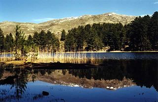
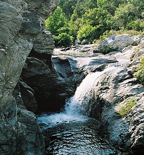
The Restonica is a small river in the department of Haute-Corse, Corsica, France. It is a tributary of the river Tavignano. The river has a steep and rocky course with many pools and waterfalls. The valley contains two lakes, and is a popular tourist destination.
The Tagnone is a small river in the department of Haute-Corse, Corsica, France. It is a tributary of the river Tavignano.
The Sisco is a small coastal stream in the department of Haute-Corse, Corsica, France. It enters the Tyrrhenian Sea from the east of the Cap Corse peninsula.
The Ruisseau de Pietracorbara is a coastal stream in the department of Haute-Corse, Corsica, France. It rises in the Monte Stello massif on Cap Corse and flows into the Tyrrhenian Sea on the east of the island.
The Chiuvone is a small river in the department of Corse-du-Sud, Corsica, France. It is a tributary of the river Rizzanese. There is a small hydroelectric power dam on the river.
The Ortolo is a coastal river in the southwest of the department of Corse-du-Sud, Corsica, France. It is dammed to store water for irrigation.
The Sagone is a coastal river in the northwest of the department of Corse-du-Sud, Corsica, France.
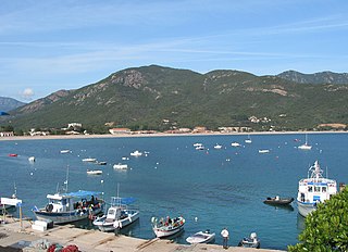
Sagone is a small seaside resort on the west coast of the island of Corsica in the commune of Vico. The settlement dates back to the 4th century, when a Roman villa was built there, with other buildings for slaves or peasants. A Christian church was built in the 5th or 6th century, later abandoned. A new cathedral was built in the 12th century, seat of the Roman Catholic Diocese of Sagone. The Genoese built a tower in the 16th century to defend Sagone against Barbary pirates. By the 18th century the town was deserted and the cathedral had been abandoned. The tower was badly damaged in 1811 during an attack by the British. Today the village is growing again due to tourism.
The Liscia is a coastal river in the west of the department of Corse-du-Sud, Corsica, France.
The Liamone landscape is an area of Corsica defined under the European Landscape Convention, which promotes the protection, management and planning of the landscapes and organizes international co-operation on landscape issues.
The Cruzzini is a river in the center of the department of Corse-du-Sud, Corsica, France. It is a tributary of the river Liamone. The valley is isolated, heavily wooded, and surrounded by high and steep mountains. There is little tourism, and the population is poorer and older than in the island as a whole.
The Guagno is a river in the north of the department of Corse-du-Sud, Corsica, France. It is a tributary of the river Liamone.
The Porto is a small coastal river in the northwest of the department of Corse-du-Sud, Corsica, France.
The Varagno is a stream in the department of Haute-Corse, Corsica, France. It is a tributary of the Fiumorbo.