
The Kalahari Desert is a large semi-arid sandy savanna in Southern Africa extending for 900,000 square kilometres (350,000 sq mi), covering much of Botswana, as well as parts of Namibia and South Africa.
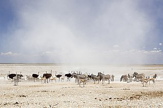
Etosha National Park is a national park in northwestern Namibia and one of the largest national parks in Africa. It was proclaimed a game reserve in March 1907 in Ordinance 88 by the Governor of German South West Africa, Friedrich von Lindequist. It was designated as Wildschutzgebiet in 1958, and was awarded the status of national park in 1967, by an act of parliament of the Republic of South Africa. It spans an area of 22,270 km2 (8,600 sq mi) and was named after the large Etosha pan which is almost entirely within the park. With an area of 4,760 km2 (1,840 sq mi), the Etosha pan covers 23% of the total area of the national park. The area is home to hundreds of species of mammals, birds and reptiles, including several threatened and endangered species such as the black rhinoceros. Sixty-one black rhinoceros were killed during poaching in Namibia during 2022, 46 of which were killed in Etosha.

Natural salt pans or salt flats are flat expanses of ground covered with salt and other minerals, usually shining white under the sun. They are found in deserts and are natural formations.

The Cunene or Kunene is a river in Southern Africa. It flows from the Angola highlands southwards to the border with Namibia. It then flows in a westerly direction along the border until it reaches the Atlantic Ocean.
Kaokoland was an administrative unit and a bantustan in northern South West Africa. Established in 1980 during the apartheid era, it was intended to be a self-governing homeland of the Ovahimba, but an actual government was never established, and the territory was administered by the leaders of Hereroland. Like other homelands in South West Africa, the Kaokoland bantustan was abolished in May 1989, at the beginning of the transition of Namibia towards independence.
Sekele is the northern language of the ǃKung dialect continuum. It was widespread in southern Angola before the Angolan Civil War, but those varieties are now spoken principally among a diaspora in northern Namibia. There are also a number of dialects spoken in far northern Namibia.

The Etosha Pan is a large endorheic salt pan, forming part of the Cuvelai-Etosha Basin in the north of Namibia. It is a vast hollow in the ground in which water may collect or in which a deposit of salt remains after water has evaporated. The 120-kilometre-long (75-mile-long) dry lakebed and its surroundings are protected as Etosha National Park, Namibia's second-largest wildlife park, covering 22,270 square kilometres (8,600 sq mi). The pan is mostly dry but after heavy rains it is flooded with a thin layer of water, which is heavily salted by the mineral deposits on the surface.

Outjo is a town of 15,000 inhabitants in the Kunene Region of Namibia. It is the district capital of Outjo Constituency. It is best known as the main gateway to Etosha National Park.

Angolan mopane woodlands are situated in southwestern Angola, extending into northern Namibia. This ecosystem surrounds Etosha Pan, which is considered a separate ecoregion. The mopane trees are the main type of vegetation.

Samuel Abraham Peyavali "Peya" Mushelenga is a Namibian politician and poet. He is broadly educated, holding fourteen academic qualifications from seven different universities.

The Ekuma River is one of three rivers that supply most of water to the pan in the Etosha National Park in Namibia, the other two being the Oshigambo River and the Omurambo Ovambo River. The Ekumo is an ephemeral river that occasionally flows, or forms pools, during the rainy season. It originates from the southern shores of Lake Oponono and is 250 kilometres (160 mi) long.
Onamukulo is a village in the Ohangwena Region of northern Namibia. It is 225 kilometres (140 mi) north of Windhoek and belongs to Omulonga Constituency. It is situated about 10 kilometres (6.2 mi) north of Oshigambo village.
Oshigambo High School, also Oshigambo Senior Secondary School, is a school in Oshigambo in the Oshikoto Region of northern Namibia. It is situated approximately 30 km east of Ondangwa.
The Oshigambo River is an ephemeral river in central northern Namibia, flowing into Etosha Pan. It almost never carries surface water but flowed and broke its banks in 2006, flooding Oshigambo, a village it cuts through. Students at the Oshigambo High School were affected by the 2011 flood. The bridge connecting the female hostel to the school was under water due to the heavy rains. The flooding claimed several lives during the past few years.
Okatana is an ephemeral river in the north of Namibia. It forms part of the Cuvelai basin. It has two channels, one running through Oshakati, serving as the boundary between the constituencies of Oshakati West and Oshakati East; the other running east of town. The two channels rejoin south of Oshakati, and the river flows into the Etosha pan. The river provides a source of water to people who leave nearby the river and food during rainy season. During rainy season it affects the community economically, socially and educationally. The ways are cut off; schools are closed due to this river. This is always made difficult for the students and teachers to close this river.

Lake Oponona is a natural lake in the Uuvudhiya Constituency in the Oshana Region of northern Namibia. It is situated about 70 kilometres (43 mi) from Etosha Pan and is the largest lake in the Cuvelai Basin.
The Omuramba Ovambo is an omuramba in Namibia. It originates about five kilometers from Tsintsabis and flows into Etosha Pan. Its catchment area is 15,784 square kilometres (6,094 sq mi). This river only flows when there is heavy rainfall. The river has almost no organic life in it due to its fluctuating water levels. The river banks are filled with rows of Camelthorn and Acacia trees which provide shade to the surrounding animals and San people who live in the area.
The Cuvelai-Etosha Basin is a transboundary wetland area shared by Angola and Namibia extending over 450 kilometres from north to south. Covering almost 160,000 km2, the widest point of the basin is along the Angola-Namibia border from the Kunene River east to the Okavango River.
