
Kangchenjunga, also spelled Kanchenjunga, Kanchanjanghā and Khangchendzonga, is the third-highest mountain in the world. Its summit lies at 8,586 m (28,169 ft) in a section of the Himalayas, the Kangchenjunga Himal, which is bounded in the west by the Tamur River, in the north by the Lhonak River and Jongsang La, and in the east by the Teesta River. It lies in the border region between Nepal and Sikkim state of India, with three of the five peaks, namely Main, Central and South, directly on the border, and the peaks West and Kangbachen in Nepal's Taplejung District.

K2, at 8,611 metres (28,251 ft) above sea level, is the second-highest mountain on Earth, after Mount Everest at 8,849 metres (29,032 ft). It lies in the Karakoram range, partially in the Gilgit-Baltistan region of Pakistan-administered Kashmir and partially in the China-administered Trans-Karakoram Tract in the Taxkorgan Tajik Autonomous County of Xinjiang.

Annapurna is a mountain situated in the Annapurna mountain range of Gandaki Province, north-central Nepal. It is the 10th highest mountain in the world at 8,091 metres (26,545 ft) above sea level and is well known for the difficulty and danger involved in its ascent.

Reinhold Andreas Messner is an Italian climber, explorer, and author from South Tyrol. He made the first solo ascent of Mount Everest and, along with Peter Habeler, the first ascent of Everest without supplemental oxygen. He was the first person to climb all 14 eight-thousanders, doing so without supplementary oxygen. Messner was the first to cross Antarctica and Greenland with neither snowmobiles nor dog sleds and also crossed the Gobi Desert alone. He is widely considered as the greatest mountaineer of all time.

Ismoil Somoni Peak is the highest mountain in Tajikistan. Because it was within the territory of the former Russian Empire and the former Soviet Union, it was the highest mountain in the Russian Empire and Soviet Union before Tajikistan became independent. The mountain is named after Ismail Samani, a ruler of the Samanid dynasty. It is located in the Pamir Range.
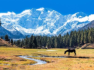
Nanga Parbat, known locally as Diamer, is the ninth-highest mountain on Earth and its summit is at 8,126 m (26,660 ft) above sea level. Lying immediately southeast of the northernmost bend of the Indus River in the Gilgit-Baltistan region of Pakistan-administered Kashmir, Nanga Parbat is the westernmost major peak of the Himalayas, and thus in the traditional view of the Himalayas as bounded by the Indus and Yarlung Tsangpo/Brahmaputra rivers, it is the western anchor of the entire mountain range.

Broad Peak is one of the eight-thousanders, and is located in the Karakoram range spanning Gilgit-Baltistan, Pakistan and Xinjiang, China. It is the 12th highest mountain in the world with 8,051 metres (26,414 ft) elevation above sea level. This peak achieved its first ascent in June 1957, accomplished by Fritz Wintersteller, Marcus Schmuck, Kurt Diemberger, and Hermann Buhl as part of an Austrian expedition.

Gasherbrum II ; surveyed as K4, is the 13th highest mountain in the world at 8,035 metres (26,362 ft) above sea level. It is the third-highest peak of the Gasherbrum massif, and is located in the Karakoram, on the border between Gilgit–Baltistan, Pakistan and Xinjiang, China. The mountain was first climbed on July 7, 1956, by an Austrian expedition which included Fritz Moravec, Josef Larch, and Hans Willenpart.

The Grossglockner, or just Glockner, is, at 3,798 metres above the Adriatic (12,461 ft), the highest mountain in Austria and the highest mountain in the Alps east of the Brenner Pass. It is part of the larger Glockner Group of the Hohe Tauern range, situated along the main ridge of the Central Eastern Alps and the Alpine divide. The Pasterze, Austria's most extended glacier, lies on the Grossglockner's eastern slope.
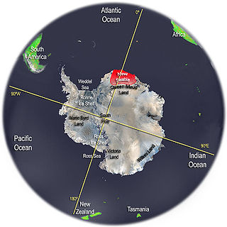
New Swabia was a disputed Antarctic claim by Nazi Germany within the Norwegian territorial claim of Queen Maud Land and is now a cartographic name sometimes given to an area of Antarctica between 20°E and 10°W in Queen Maud Land. New Swabia was explored by Germany in early 1939 and named after that expedition's ship, Schwabenland, itself named after the German region of Swabia.

The Ramu River is a major river in northern Papua New Guinea. The headwaters of the river are formed in the Kratke Range from where it then travels about 640 km (398 mi) northwest to the Bismarck Sea.
Wohlthat Mountains is a large group of associated mountain features consisting of the Humboldt Mountains, Petermann Ranges, and the Gruber Mountains, located immediately east of the Orvin Mountains in Fimbulheimen in the central Queen Maud Land. Discovered by the Third German Antarctic Expedition (1938–1939), led by Capt. Alfred Ritscher, and named for Prussian State Councilor Helmuth Wohlthat, who as economist and fiscal officer dealt with the organization of the expedition.
The Humboldt Mountains are a group of mountains immediately west of the Petermann Ranges, forming the westernmost portion of the Wohlthat Mountains in Queen Maud Land, Antarctica.

Ising Glacier is a glacier flowing northwest between Isingen Mountain and Kvitkjolen Ridge in the Sverdrup Mountains of Queen Maud Land, Antarctica. It was photographed from the air by the Third German Antarctic Expedition (1938–39). It was mapped by Norwegian cartographers from surveys and air photos by the Norwegian–British–Swedish Antarctic Expedition (1949–1952), led by John Schjelderup Giæver, and from air photos by the Norwegian expedition (1958–59) and named Isingbreen.
Queen Maud Land is a roughly 2.7-million-square-kilometre (1.0-million-square-mile) region of Antarctica claimed by Norway as a dependent territory. It borders the claimed British Antarctic Territory 20° west and the Australian Antarctic Territory 45° east. In addition, a small unclaimed area from 1939 was annexed in June 2015. Positioned in East Antarctica, it makes out about one-fifth of the continent, and is named after the Norwegian queen Maud of Wales (1869–1938).
Anuchin Glacier is a glacier draining southward to Lake Unter-See in the northern part of the Gruber Mountains, Queen Maud Land. It was discovered, and plotted from air photos, by the Third German Antarctic Expedition, 1938–39. It was mapped from air photos and from surveys by the Sixth Norwegian Antarctic Expedition, 1956–60, and remapped by the Soviet Antarctic Expedition, 1960–61, and named after Dmitry Nikolayevich Anuchin, Soviet geographer.
Asimutbreen Glacier is a small, steep tributary glacier to Vangengeym Glacier, descending southeast and then northeast between Solhogdene Heights and Skuggekammen Ridge, in the eastern Gruber Mountains of the Wohlthat Mountains, Queen Maud Land. It was discovered and plotted from air photos by the Third German Antarctic Expedition, 1938–39, replotted from air photos and from surveys by the Sixth Norwegian Antarctic Expedition, 1956–60, and named Asimutbreen.
Barkov Glacier is a glacier draining northeast between Mount Dallmann and the central part of the Shcherbakov Range, in the Orvin Mountains, Queen Maud Land. First photographed and roughly plotted by the Third German Antarctic Expedition, 1938–39, it was mapped from air photos and surveys by the Sixth Norwegian Antarctic Expedition, 1956–60, remapped by the Soviet Antarctic Expedition, 1960–61, and named after Soviet geographer A.S. Barkov.

The Gruber Mountains are a small group of mountains consisting of a main massif and several rocky outliers, forming the northeast portion of the Wohlthat Mountains in Queen Maud Land, Antarctica. They were discovered and plotted from air photos by the Third German Antarctic Expedition (GerAE), 1938–39, under Alfred Ritscher. The mountains were remapped by the Sixth Norwegian Antarctic Expedition, 1956–60, who named them for Otto von Gruber, the German cartographer who compiled maps of this area from air photos taken by the GerAE. This feature is not to be confused with "Gruber-Berge," an unidentified toponym applied by the GerAE in northern the Mühlig-Hofmann Mountains.
