The Berrys River is a 12.9-mile (20.8 km) long river located in southeastern New Hampshire in the United States. It is a tributary of the Isinglass River, part of the Cocheco River/Piscataqua River watershed leading to the Atlantic Ocean.
Radava is a township in the Centar municipality, part of the city Sarajevo, Federation of Bosnia and Herzegovina, Bosnia and Herzegovina.
The Villa Publica was a public building in ancient Rome, which served as the censors’ base of operation. It was erected on the Campus Martius in 435 BC. According to Livy, the first census was compiled there the year it was built. In 194 BC, the building, or buildings, was restored and enlarged. Villa Publica meant "House of the People" and although its location is unknown, it is known from ancient sources that its area was wide, and that, at one point, most likely following further renovations in 34 BC, a large wall was built around it. In addition to holding the censors’ records and acting as the censors’ base of operations, the Villa Publica also served as a place where foreign ambassadors were greeted, where generals waited to hear if they would be granted a triumph, and it also acted as a base for army levies.

Savard is an unincorporated township in the Canadian province of Ontario, located in the Timiskaming District. It is located immediately west of the municipality of Chamberlain.

The Teatro Valle is a theatre and former opera house in Rome, Italy.
Wimblington railway station was a station in the village of Wimblington, Cambridgeshire. It was closed in 1967 as part of the Beeching Axe.The station was demolished in the early 1970s and the site used for the construction of the new alignment of the A141 road.
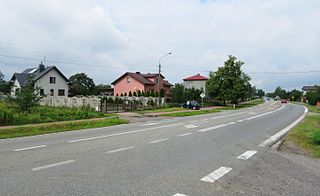
Stare Kozłowice is a village in the administrative district of Gmina Wiskitki, within Żyrardów County, Masovian Voivodeship, in east-central Poland.

Aalto-Hochhaus is a 22-floor high-rise apartment building in Bremen, Germany, designed by Alvar Aalto. It is approximately 60 meters tall and was completed in 1962. Since 1998, it is protected by the monument protection act.

Longsdorf is a village in the commune of Tandel, Luxembourg.
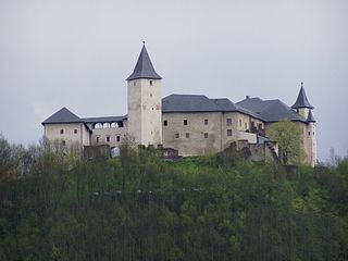
Schloss Straßburg is a castle in Straßburg, Carinthia, Austria. Schloss Straßburg is 754 metres (2,474 ft) above sea level.
St. Demetrius' Church is a church in Tuminec, Korçë County, Albania. It is a Cultural Monument of Albania.
Al-Berka (Arabic:البركة) is a Basic People's Congress administrative division of Benghazi, Libya. As of the 2011 Libyan revolution, the area is simply known as a district of Benghazi after the Gaddafi era Basic People's Congresses were disbanded.
Velgonda is a village in Karimnagar district, Telangana, India. It falls under Dharmapuri mandal. The National Highway 16 or NH-16 passes through this village.

Perutina is a village situated in Doljevac municipality in Serbia.
Sarıyar is a village in the Vezirköprü, Samsun Province, Turkey.

The Old Palace, also referred to as the Archbishop's Palace, is a historic building situated within the precincts of Canterbury Cathedral. It is the main residence of the Archbishop of Canterbury when in Canterbury.
Seventy-Six Township is a township in Washington County, Iowa, USA.
Rättvik Arena is an indoor bandy venue and event arena for music and culture in Rättvik, Dalarna County, Sweden, which officially opened on 13 June 2010 with performances by music artists like Kalle Moraeus and Ola Svensson. The arena was completed already by November 2009.
The Temple of Minerva Chalcidica or Minervium was a small temple in the Campus Martius in ancient Rome, dedicated to Minerva. It was built by Pompey the Great in around 60 BC and probably destroyed in the fire of 80 AD which destroyed the Campus Martius. It was then rebuilt by Domitian.

Iron Latch is a 4.3 hectare nature reserve in Eight Ash Green, west of Colchester in Essex.


