Otter Trail

Last updated

Otter Trail
Otter Trail03.jpg
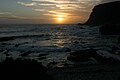
View from Skilderkrans across Bloubaai-Wes
Length41 km (25 mi)
Location Garden Route, South Africa
Trailheads Storms River Mouth
Nature's Valley
UseHiking
Trail map
Otter Trail
Otter Trail
Kilometres
End
6.8
BSicon fENDEa.svg
De Vasselot Campsite
BSicon fSTR.svg
Grootrivier Mouth (Nature's Valley)
BSicon fSTR.svg
BSicon uVEEgq.svg
BSicon WASSERq.svg
Klip River Mouth
13.8
BSicon BUILDINGr.svg
BSicon fSTR.svg
Andre Huts
BSicon fSTR.svg
BSicon uVEEgq.svg
BSicon WASSERq.svg
Bloukrans River Mouth
BSicon fSTR.svg
BSicon nENDEaq.svg
BSicon nCONTfq.svg
Escape Route 6
7.7
BSicon BUILDINGr.svg
BSicon fSTR.svg
Oakhurst Huts
BSicon fSTR.svg
BSicon uVEEgq.svg
BSicon WASSERq.svg
Lottering River Mouth
BSicon fSTR.svg
BSicon nENDEaq.svg
BSicon nCONTfq.svg
Escape Route 5
BSicon fSTR.svg
BSicon uVEEgq.svg
BSicon WASSERq.svg
Elandsbos River Mouth
BSicon fSTR.svg
BSicon nENDEaq.svg
BSicon nCONTfq.svg
Escape Route 4
7.9
BSicon BUILDINGr.svg
BSicon fSTR.svg
Scott Huts
BSicon fSTR.svg
BSicon nENDEaq.svg
BSicon nCONTfq.svg
Escape Route 3
BSicon fSTR.svg
BSicon uVEEgq.svg
BSicon WASSERq.svg
Kleinbos River Mouth
BSicon fSTR.svg
BSicon nENDEaq.svg
BSicon nCONTfq.svg
Escape Route 2
BSicon fSTR.svg
BSicon nENDEaq.svg
BSicon nCONTfq.svg
Escape Route 1
4.8
BSicon BUILDINGr.svg
BSicon fSTR.svg
Ngubu Huts
BSicon fSTR.svg
BSicon unKSTRaq.svg
BSicon unCONTfq.svg
Blue Duiker Waterfall Trail
BSicon fENDEe.svg
Storms River Camp
Start
BSicon uVEEgq.svg
BSicon WASSERq.svg
Storms River Mouth

The Otter Trail is a hiking trail along the Garden Route coast of South Africa and is named for the Cape clawless otter [1] which occurs in this region. This trail is widely regarded as one of the finest in the world and stretches from Storms River Mouth in the east to Nature's Valley in the west, is 26 km long as the crow flies and 44 km as the hiker walks. Walking the trail takes 5 days, and the 4 nights are spent in comfortable huts with superb views. The route is located entirely within the Tsitsikamma National Park, which protects an 80 km long strip of coastal mountains, forest and beaches.

Contents

The trail traverses a very scenic landscape, never straying far from the shoreline, but often climbing steeply and then descending to the beach or a river crossing. Vegetation along the way is either fynbos, dense gallery forest or open, rocky sections near the sea with an abundance of wildflowers.

Trail landmarks

Trail stages

Elevation distances - vertical climb and descent

See also

Related Research Articles

<span class="mw-page-title-main">Mont Blanc</span> Highest mountain in the Alps (4,808 m)

Mont Blanc is the highest mountain in the Alps and Western Europe, and the highest mountain in Europe outside the Caucasus mountains, rising 4,805.59 m (15,766 ft) above sea level, located on the French-Italian border. It is the second-most prominent mountain in Europe, after Mount Elbrus, and it is the eleventh most prominent mountain summit in the world.

<span class="mw-page-title-main">John Muir Trail</span> Trail in the Sierra Nevada mountains of California

The John Muir Trail (JMT) is a long-distance trail in the Sierra Nevada mountain range of California, passing through Yosemite, Kings Canyon and Sequoia National Parks. It is named after John Muir, a naturalist.

<span class="mw-page-title-main">Mist Trail</span> Hiking trail in Yosemite National Park, California

The Mist Trail is one of the most popular short hikes in Yosemite National Park, California, USA. The steep hike follows the Merced River, starting at Happy Isles in Yosemite Valley, past Vernal Fall and Emerald Pool, to Nevada Fall.

<span class="mw-page-title-main">Serre Chevalier</span> French ski resort in the Alps

Serre Chevalier is a major ski resort in Southeastern France, near the Italian border, located in the Hautes-Alpes department, Provence-Alpes-Côte d'Azur region. Situated to the northeast of Écrins National Park in the French Alps, the resort encompasses a large skiing area, with 250 km (155 mi) of slopes and favourable weather, boasting 300 days of sunshine a year. In Serre Chevalier, 80 km (50 mi) of the slopes are covered by snow cannons to supplement natural snowfall. The resort is owned by Compagnie des Alpes.

<span class="mw-page-title-main">Watzmann</span> Mountain in Germany

The Watzmann is a mountain in the Berchtesgaden Alps south of the village of Berchtesgaden. It is the third highest in Germany, and the highest located entirely on German territory.

<span class="mw-page-title-main">Mount Adams (New Hampshire)</span> Mountain in New Hampshire, United States

Mount Adams, elevation 5,793 feet (1,766 m) above sea level, is a mountain in New Hampshire, the second highest peak in the Northeast United States after its nearby neighbor, Mount Washington. Located in the northern Presidential Range, Mount Adams was named after John Adams, the second President of the United States. It was given this name on July 31, 1820. To the northeast is Mount Madison and to the southwest is Mount Jefferson. From the summit, Mount Washington can be seen directly to the south.

<span class="mw-page-title-main">Routeburn Track</span> Hiking track in New Zealand

The Routeburn Track is a world-renowned, 32 km tramping (hiking) track found in the South Island of New Zealand. The track can be done in either direction, starting on the Queenstown side of the Southern Alps, at the northern end of Lake Wakatipu or on the Te Anau side, at the Divide, several kilometres from the Homer Tunnel to Milford Sound.

<span class="mw-page-title-main">Toubkal</span> Highest peak of the Atlas mountain range

Toubkal or Tubkal, also Jbel Toubkal or Jebel Toubkal, is a mountain peak in southwestern Morocco, located in the Toubkal National Park. At 4,167 m (13,671 ft), it is the highest peak in Morocco, the Atlas Mountains, North Africa and the Arab world. Located 63 km (39 mi) south of the city of Marrakesh, and visible from it, Toubkal is an ultra prominent peak, the highest for over 2,000 km (1,200 mi). Toubkal is ranked 27th by topographic isolation.

At 47,527 acres (192.33 km2), Harriman State Park is the second largest state park in the U.S. state of New York. Located in Rockland and Orange counties 30 miles (48 km) north of New York City, it is a haven for hikers with over 200 miles (320 km) of hiking trails. The park is also known for its 31 lakes, multiple streams, public camping area, and great vistas. The park's hiking trails are currently maintained by volunteers from the New York - New Jersey Trail Conference.

<span class="mw-page-title-main">Tsitsikamma National Park</span> Protected area on the Garden Route, Western Cape and Eastern Cape, South Africa

The Tsitsikamma National Park is a protected area on the Garden Route, Western Cape and Eastern Cape, South Africa. It is a coastal reserve well known for its indigenous forests, dramatic coastline, and the Otter Trail. On 6 March 2009 it was amalgamated with the Wilderness National Park and various other areas of land to form the Garden Route National Park.

<span class="mw-page-title-main">Porters Ski Area</span> Ski field in Canterbury, New Zealand

Porters, is a commercial ski resort just over an hour's drive (98km) west from Christchurch, in the South Island of New Zealand. Originally functioning as a club skifield, it has one beginner magic carpet, one platter tow, one chairlift and three t-bars. The difficulty of the slopes is distributed as 15% beginner, 35% intermediate and 50% advanced. Modern grooming equipment is used, and snowmaking facilities operate along the main pistes along the chairlift.

<span class="mw-page-title-main">Angels Landing</span> Rock formation in Zion National Park, Utah, United States

Angels Landing, known previously as the Temple of Aeolus, is a 1,488-foot (454 m) tall rock formation in Zion National Park in southwestern Utah, United States. A renowned trail cut into solid rock in 1926 leads to the top of Angels Landing and provides panoramic views of Zion Canyon.

<span class="mw-page-title-main">Lemberg (Swabian Jura)</span>

The Lemberg is a mountain located in the Tuttlingen district of Baden-Württemberg, Germany. The mountain is the highest point of the Swabian Jura. It is one of the "Ten Thousanders" —ten 1,000-metre-high summits of the region. On the peak of the mountain is a 30-m-high tower which, reaching above the surrounding trees, offers a beautiful prospect, in clear weather as far as the Alps.

<span class="mw-page-title-main">Brace Mountain</span> Mountain in New York, United States

Brace Mountain is the peak of a ridge in the southern Taconic Mountains, near the tripoint of the U.S. states of New York, Connecticut and Massachusetts. Its 2,311-foot (704 m) main summit is located in New York; it is the highest point in that state's Dutchess County.

In cycling, hiking, mountaineering and running, cumulative elevation gain refers to the sum of every gain in elevation throughout an entire trip. It is sometimes also known as cumulative gain or elevation gain, or often in the context of mountain travel, simply gain. Another commonly used phrase is total ascent. Elevation losses are not counted in this measure. Cumulative elevation gain, along with round-trip distance, is arguably the most important value used in quantifying the strenuousness of a trip. This is because hiking 10 miles (16 km) on flat land is significantly easier than hiking up and down a large mountain with the same round-trip distance.

<span class="mw-page-title-main">Speikboden (South Tyrol)</span> Mountain in Italy

Speikboden is a massif in the Central Eastern Alps located between the three valleys Weißenbach, Mühlwald and Ahrntal. Running in a south-easterly direction, it forms the eastern part of an outlier of the western Zillertal Alps. Its highest point, likewise named Speikboden, is 2,517 m. Further well-known peaks in this massif include Seewassernock (2,516 m), Große Nock (2,400 m), Kleine Nock (2,227 m) and Gornerberg (2,475 m).

<span class="mw-page-title-main">Główny Szlak Sudecki</span>

Główny Szlak Sudecki is a public hiking trail in Poland running along the Sudetes. The total length of this route is 443 km and the approximate time to cover it's about 120 hours. The trail was constructed in 1947 and throughout its history has been several times modified. It is blazed red.

<span class="mw-page-title-main">Black Forest Trail</span>

The Black Forest Trail is a 43.0-mile (69.2 km) hiking trail in north-central Pennsylvania, forming a loop through portions of Tiadaghton State Forest and routed through Pine Creek Gorge and areas of the Allegheny Plateau above the gorge. Most of the trail is in Lycoming County, with about five miles in Potter County and a very brief segment in Clinton County. The trail was named after the region's original forest landscape, which reminded immigrant loggers of the Schwarzwald region of Germany.

<span class="mw-page-title-main">Manitou Incline</span> Hiking trail rising above Manitou Springs, Colorado, United States

The Manitou Springs Incline, also known as the Manitou Incline or simply the Incline, is a popular hiking trail rising above Manitou Springs, Colorado, near Colorado Springs. The Incline ascends on the east slope of Rocky Mountain which is itself on the eastern flank of Pikes Peak. The trail is the remains of a former 3 ft narrow gauge funicular railway whose tracks washed out during a rock slide in 1990. The Incline is famous for its sweeping views and steep grade, with an average grade of 45% (24°) and as steep as 68% (34°) in places, making it a fitness challenge for locals of the Colorado Springs area. The incline gains 2,011 feet (613 m) of elevation in 0.88 miles (1.42 km) horizontal. Currently the Incline has approximately 2,744 steps from the bottom to the summit, although the top step is numbered "2768". The number of steps changes occasionally with trail maintenance and deterioration.

<span class="mw-page-title-main">Gengenbach–Alpirsbach Black Forest Trail</span> Trail in Germany

The Gengenbach–Alpirsbach Black Forest Trail is a long distance path through the Central Black Forest in Germany. The 51-kilometre-long east-west route is sponsored and maintained by the Black Forest Club. Its waymark is a blue diamond on a yellow background.

References

  1. Delien Burger (ed.). "20. Tourism". South Africa Yearbook 2007/08 (15 ed.). South African Government Communication and Information System. p. 548. ISBN   978-0-621-37568-8. Archived from the original on 2009-04-02. Retrieved 2009-02-02.
Map all coordinates using: OpenStreetMap