
The Garden Route is a 300-kilometre (190 mi) stretch of the south-eastern coast of South Africa which extends from Witsand in the Western Cape to the border of Tsitsikamma Storms River in the Eastern Cape. The name comes from the verdant and ecologically diverse vegetation encountered here and the numerous estuaries and lakes dotted along the coast. It includes towns such as Knysna, Plettenberg Bay, Mossel Bay, Great Brak River, Little Brak River, Wilderness, Sedgefield and Nature's Valley; with George, the Garden Route's largest city and main administrative centre.
Bitou Local Municipality is a municipality part of Garden Route District Municipality located in the Western Cape Province of South Africa. Its municipality code is WC047.

Gamtoos River or Gamptoos River is a river in the Eastern Cape Province, South Africa. It is formed by the confluence of the Kouga River and the Groot River and is approximately 645-kilometre (401 mi) long with a catchment area of 34,635 square kilometres (13,373 sq mi).
The Sundays River or Nukakamma is a river in the Eastern Cape Province of South Africa. It is said to be the fastest flowing river in the country. The Khoisan people originally named this river Nukakamma because the river's banks are always green and grassy despite the arid terrain that it runs through.
The Tsitsikamma National Park is a protected area on the Garden Route, Western Cape and Eastern Cape, South Africa. It is a coastal reserve well known for its indigenous forests, dramatic coastline, and the Otter Trail. On 6 March 2009 it was amalgamated with the Wilderness National Park and various other areas of land to form the Garden Route National Park.
Groot River or Grootrivier may refer to:

Nature's Valley is a holiday resort and small village on the Garden Route along the southern Cape coast of South Africa. Nature's Valley lies between the Salt River, the foothills of the Tsitsikamma Mountains, the Indian Ocean and the Groot River lagoon. Nature's Valley has a balmy climate and is surrounded by the de Vasselot Nature Reserve which is part of the Tsitsikamma Park, and in turn part of the Garden Route National Park.

The Tsitsikamma mountains form an east-west mountain range located in the Garden Route region of the southern South African coast in the Western Cape and Eastern Cape provinces. Tsitsikamma means 'place of much water' in the Khoekhoe language.

The Kou-Kamma Municipality is a local municipality in South Africa. It is situated in the southwest corner of the Sarah Baartman District Municipality along the Indian Ocean coastline, in the southwestern sector of South Africa's Eastern Cape Province. To the west lies the Western Cape Province. Kou-Kamma also borders the Dr Beyers Naudé Local Municipality in the north and the Kouga Local Municipality to the east. The geographical area of the Municipality is 12,540 square kilometres. Its name is a blend of the names of the Kouga (Kou-) and Tsitsikamma (-Kamma) mountains, which in turn were named after the rivers Kouga and Tsitsikamma.
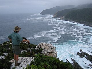
The Otter Trail is a hiking trail along the Garden Route coast of South Africa and is named for the Cape clawless otter which occurs in this region. This trail is widely regarded as one of the finest in the world and stretches from Storms River Mouth in the east to Nature's Valley in the west, is 26 km long as the crow flies and 44 km as the hiker walks. Walking the trail takes 5 days, and the 4 nights are spent in comfortable huts with superb views. The route is located entirely within the Tsitsikamma National Park, which protects an 80 km long strip of coastal mountains, forest and beaches.
Eastern Cape Parks are the national parks, marine protected areas, nature reserves and other nature conservation areas in the Eastern Cape province of South Africa. Eastern Cape Parks and Tourism Agency (ECPTA) is the governmental organisation responsible for maintaining wilderness areas and public nature reserves in the Eastern Cape, based in East London.
The Garden Route National Park is a national park in the Garden Route region of the Western Cape and Eastern Cape provinces in South Africa. It is a coastal reserve well known for its indigenous forests, dramatic coastline, and the Otter Trail. It was established on 6 March 2009 by amalgamating the existing Tsitsikamma and Wilderness National Parks, the Knysna National Lake Area, and various other areas of state-owned land.

The Kouga Local Municipality is located in the Eastern Cape of South Africa, approximately 80 km west of Port Elizabeth, and forms part of the Sarah Baartman District Municipality. Its territory includes the coastal zone between the Van Stadens River in the east and the Tsitsikamma River in the west, and stretches inland towards the Baviaanskloof Mountains in the north.

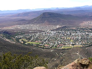
Kareedouw is a town in the Eastern Cape province of South Africa. It is the administrative centre for the Kou-Kamma Municipality in the Sarah Baartman District of the Eastern Cape.

The Bloukrans River is a short river located in the Tsitsikamma region of the Garden Route, South Africa. It is located on the border between the Western Cape and Eastern Cape provinces. The river mouth is located east of Nature's Valley, the Bloukrans Bridge spans the river near the mouth and the Bloukrans Pass is close by. The river originates near Peak Formosa in the Plettenberg Bay region.

The Tsitsikamma River is a small river at the western end of the Eastern Cape coast, South Africa. It is part of the Fish to Tsitsikama Water Management Area.
Middleton is a hamlet in the Blue Crane Route Local Municipality of the Sarah Baartman District Municipality in the Eastern Cape province of South Africa. Middleton is situated on the banks of the Fish River off the N10 road and is about 30 km south of Cookhouse.
The Tstsikamma Marine Protected Area is a marine protected area on the south coast of South Africa, in both the Western Cape and Eastern Cape. It is on the coast of the Tsitsikamma National Park, and is one of the oldest MPAs in the country. The MPA provides protection for marine habitat and wildlife, including birds and threatened and endangered fish species.
The following index is provided as an overview of and topical guide to the protected areas of South Africa:

