Oud-Rekem

Last updated
Oud-Rekem
Village
Oud-Rekem03.jpg
The gardens of Aspremont-Lynden Castle
Belgium location map.svg
Red pog.svg
Oud-Rekem
Location in Belgium
Coordinates: 50°55′30″N5°42′26″E / 50.9250°N 5.7072°E / 50.9250; 5.7072 Coordinates: 50°55′30″N5°42′26″E / 50.9250°N 5.7072°E / 50.9250; 5.7072
Country Flag of Belgium (civil).svg  Belgium
Region Flemish Region
Province Limburg
Municipality Lanaken
Area
[1]
  Total0.25 km2 (0.10 sq mi)
Population
 (2021) [1]
  Total415
  Density1,700/km2 (4,300/sq mi)
Time zone CET

Oud-Rekem is a village in the Lanaken municipality of the Limburg province of Belgium. The village is considered one of the most authentic villages of Belgium. [2] [3] Since 1994, it is protected as a monument. [4]

Contents

History

Oud-Rekem was first mentioned in 1140 as Radekeim. [4] The village was first a heerlijkheid . In 1356, it became a barony, and was elevated to county in 1623. [5]

During the 16th, 17th and 18th century, the town was located in a heavily contested area. Oud-Rekem was plundered, and had to station troops on multiple occasions. [4] In 1602, the first walls were erected around the town. Between 1625 and 1630, a second layer of defence was erected. In 1638, a third wall was built in between the first and second. Even though the walls were removed between 1825 and 1836, traces are still visible. [4]

In 1795 or 96, Oud-Rekem became part of Rekem, [5] and in 1977, the municipality was merged into Lanaken. [6]

In 1994, the old centre was protected as a monument. [4] Oud-Rekem won the election for most beautiful village of Flanders  [ nl ] in 2008. [3] [7]

Sights

Donkeys in Oude Weerd Rekem Oude Weerd 14-11-2020 11-44-19.jpg
Donkeys in Oude Weerd

The Aspremont-Lynden Castle is located in the centre. The original castle dated from the Carolingian era. A larger castle was built in 1350 and existed until 1507. In 1597, the current castle was built by Count Herman d'Aspremont-Lynden. In 1792, the castle was confiscated by the French who demolished parts of the building. In 1921, the castle became a psychiatric hospital. The castle is surrounded by a large garden. [8]

The Oude Weerd  [ nl ] is a nearby nature reserve which consists of grasslands, hedges, and pools. It is home to badgers and beavers. [9]

Related Research Articles

<span class="mw-page-title-main">Oud-Turnhout</span> Municipality in Flemish Community, Belgium

Oud-Turnhout is a municipality located in the Belgian province of Antwerp. The municipality only comprises the town of Oud-Turnhout proper. In 2021, Oud-Turnhout had a total population of 14,201. The total area is 38.80 km².

<span class="mw-page-title-main">Houtem</span> Village in Flemish Region

Houtem is a village in the municipality of Veurne in the Belgian province of West Flanders. The village is located near the French border. Until 1977, Houtem was an independent municipality. During World War I, it was home to the Headquarters of the Belgian Army.

<span class="mw-page-title-main">Aspremont-Lynden Castle</span>

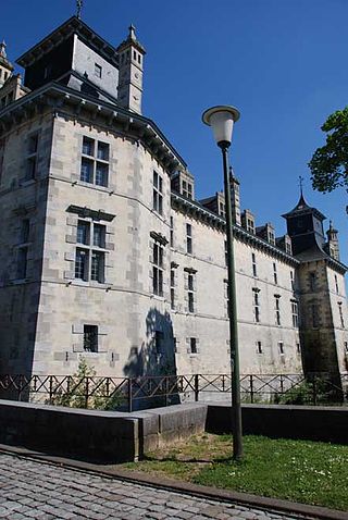
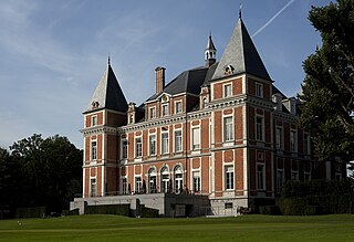
Aspremont-Lynden Castle is a castle in Oud-Rekem in the municipality of Lanaken, province of Limburg, Belgium.

<span class="mw-page-title-main">Erwetegem</span> Village in Flemish Region

Erwetegem is a village and deelgemeente (sub-municipality) belonging to the municipality of Zottegem. It is located in the Denderstreek and in the Flemish Ardennes, the hilly southern part of the province of East Flanders, Belgium. Erwetegem used to be an independent municipality until 1970.

<span class="mw-page-title-main">Wechelderzande</span> Town in Flemish Region

Wechelderzande is a town situated in the Campine region of the Antwerp Province in Belgium. It has been part of the municipality of Lille since 1977.

<span class="mw-page-title-main">Hingene</span> Village in Flemish Region

Hingene is a village and deelgemeente (sub-municipality) of the municipality of Bornem in the province of Antwerp, Belgium. The village is bordered to the north by the Scheldt and to the east by the Rupel. It is located about 16 kilometres (9.9 mi) south-west of the city of Antwerp.

<span class="mw-page-title-main">Oelegem</span> Village in Flemish Region

Oelegem is a village and deelgemeente (sub-municipality) of the municipality of Ranst in the province of Antwerp, Belgium. The village is located about 14 kilometres (8.7 mi) east of the city of Antwerp.

<span class="mw-page-title-main">Vinderhoute</span> Village in Flemish Region

Vinderhoute is a village in the municipality of Lievegem in the province of East Flanders in Belgium. It is located in the Flemish Valley about 6 kilometres (3.7 mi) north-west of Ghent.

<span class="mw-page-title-main">Zevergem</span> Village in Flemish Region

Zevergem is a village and deelgemeente (sub-municipality) of De Pinte in East Flanders, Belgium. It is located on the Scheldt about 8 kilometres (5.0 mi) south of Ghent.

<span class="mw-page-title-main">Bellem</span> Village in East Flanders, Belgium

Bellem is a village and deelgemeente (sub-municipality) in the municipality of Aalter in the Belgian province of East Flanders. The village was originally called Bethlehem. Bellem is located about 16 kilometres (9.9 mi) west of Ghent.

<span class="mw-page-title-main">Kerkom-bij-Sint-Truiden</span> Village in Flemish Community, Belgium

Kerkom-bij-Sint-Truiden is a village in the Sint-Truiden municipality of the Limburg province in the Flemish Community of Belgium. Kerkom-bij-Sint-Truiden was an independent municipality until 1970 when it merged with Borlo. In 1976, the village opted to become part of Sint-Truiden.

<span class="mw-page-title-main">Morkhoven</span> Village in Flemish Region

Morkhoven is a village in the Belgian province of Antwerp belonging to the municipality of the city of Herentals.

<span class="mw-page-title-main">Kieldrecht</span> Village in Flemish Region

Kieldrecht is a village and deelgemeente (sub-municipality) of Beveren in East Flanders, Belgium. Kieldrecht was an independent municipality until 1977, when it merged with Beveren as part of the fusion of municipalities in Belgium. The village is located on the border with the Netherlands, and forms a single urban area with the Dutch village of Nieuw-Namen.

<span class="mw-page-title-main">Haasdonk</span> Village in Flemish Region

Haasdonk is a village and deelgemeente (sub-municipality) of Beveren in East Flanders, Belgium. Haasdonk was an independent municipality until 1 January 1977, when it merged with Beveren as part of the fusion of municipalities in Belgium. It is located about 12 kilometres (7.5 mi) west of Antwerp.

<span class="mw-page-title-main">Liezele</span> Village in Flemish Region

Liezele is a village and deelgemeente (sub-municipality) of the municipality of Puurs-Sint-Amands in the province of Antwerp, Belgium. The village is located about 20 kilometres (12 mi) south-south-west of the city of Antwerp. On the night of 4 to 5 September 1914, the entire village was destroyed by the Belgian Army to deny the Germany Army cover.

<span class="mw-page-title-main">Watervliet, Belgium</span> Village in Flemish Region

Watervliet is a village in the Belgian province of East Flanders and suburb of the town of Sint-Laureins. Watervliet is part of the Meetjesland, and is adjacent to the Dutch border. It was a separate municipality until 1977.

<span class="mw-page-title-main">Rutten, Belgium</span> Village and former municipality in Flanders

Rutten is a village in the Tongeren municipality of the Limburg province in the Flemish Community of Belgium. The village is located in the Haspengouw region, and was a separate municipality until its merger into Tongeren in 1977.

<span class="mw-page-title-main">Petegem-aan-de-Schelde</span> Village in Flemish Region

Petegem-aan-de-Schelde is a village and former municipality in the Wortegem-Petegem municipality in the Belgian province of East Flanders. The village officially changed its name from Petegem into Petegem-aan-de-Schelde in order to distinguish itself from Petegem-aan-de-Leie. In 1971, the municipality merged into Wortegem-Petegem.

<span class="mw-page-title-main">Bevere, Belgium</span> Village in Flemish Region

Bevere is a village in the municipality of Oudenaarde. It is located in the Flemish Ardennes, the hilly southern part of the province of East Flanders, Belgium. In the mid-19th century, it started to form a single urban area with Oudenaarde, but retained some rural parts.

<span class="mw-page-title-main">Tongerlo</span> Village in Flemish Region

Tongerlo is a village and deelgemeente (sub-municipality) of the municipality of Westerlo in the province of Antwerp, Belgium. The village is located about 10 kilometres (6.2 mi) south-east of the city of Herentals. Tongerlo is best known for Tongerlo Abbey founded in 1128 which became one of the most important abbeys of Belgium.

References

  1. 1 2 "Bevolking per statistische sector - Sector 73042B00". Statistics Belgium. Retrieved 6 May 2022.
  2. "Oud - Rekem". River Park Maas Vallei (in Dutch). Retrieved 27 February 2021.
  3. 1 2 "Mooiste Dorp Oud-Rekem". Lanaken (in Dutch). Retrieved 27 February 2021.
  4. 1 2 3 4 5 "Historische stadskern van Oud-Rekem". Agentschap Onroerend Erfgoed (in Dutch). Retrieved 27 February 2021.
  5. 1 2 "Rekem". Agentschap Onroerend Erfgoed (in Dutch). Retrieved 27 February 2021.
  6. "Lanaken". Agentschap Onroerend Erfgoed (in Dutch). Retrieved 27 February 2021.
  7. "Lo geweerd van lijst 'Mooiste dorp van Vlaanderen'". De Standaard (in Dutch). Retrieved 27 February 2021.
  8. "Kasteel d'Aspremont-Lynden". Agentschap Onroerend Erfgoed (in Dutch). Retrieved 27 February 2021.
  9. "Oude Weerd". www.natuurpunt.be (in Dutch). Retrieved 27 February 2021.