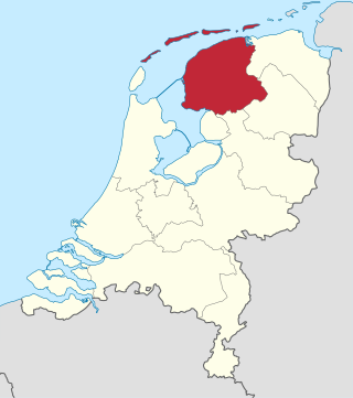
Friesland, historically and traditionally known as Frisia, named after the Frisians, is a province of the Netherlands located in the country's northern part. It is situated west of Groningen, northwest of Drenthe and Overijssel, north of Flevoland, northeast of North Holland, and south of the Wadden Sea. As of January 2023, the province had a population of about 660,000, and a total area of 5,753 km2 (2,221 sq mi).

het Bildt is a former municipality in the province of Friesland in the northern Netherlands; its capital was Sint Annaparochie. On 1 January 2018 it merged with the municipalities of Franekeradeel, Menameradiel and parts of Littenseradiel to form the new municipality Waadhoeke.

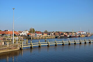
Harlingen is a municipality and a city in the northern Netherlands, in the province of Friesland.
Zoutkamp is a village in the municipality Het Hogeland which is part of the province Groningen in the Netherlands. The village started as a sconce. During the Dutch Revolt, it was the site of the Battle of Zoutkamp. Later it became a fishing village. The harbour was moved to Lauwersoog in 1969 as a result of the closure of the Lauwersmeer, and is nowadays used for recreational purposes. The economy of the village mainly depends on fishing.

Franeker is one of the eleven historical cities of Friesland and capital of the municipality of Waadhoeke. It is located north of the Van Harinxmakanaal and about 20 km west of Leeuwarden. As of 2023, it had 13,015 inhabitants. World Heritage Site the Eise Eisinga Planetarium, established in 1781, is located in the city.

Sint Annaparochie is a village in the municipality of Waadhoeke in Friesland, Netherlands. It lies approximately 15 km (9 mi) northwest of Leeuwarden and had approximately 4,830 inhabitants in 2021. The village is named after Saint Anne, the mother of Mary.

The Nieuwe Bildtdijk, "Nije dyk" in the local language of "Het Bildts", is a dike in the Dutch municipality Waadhoeke which was built around the year 1600 to protect the land from flooding. It protected the Wester Bildtpollen and the Ooster Bildtpollen from the Waddenzee. A new higher and stronger dike between it and the sea makes it no longer the first barrier to the sea. Nowadays a narrow road runs along the top of the dike and many houses and farmhouses are situated on this dike, mainly on the northern side. The Nieuwe Bildtdijk superseded the older more inland dike, the Oude Bildtdijk.
Ooster Bildtpollen is the northern-east part of the Dutch county Het Bildt in Friesland. The dikework walling off the sea was completed in 1754. The western part is called the Wester Bildtpollen and the dike that protected these lands against the sea is called the "Nieuwe Bildtdijk". Just like the older dike, the Oude Bildtdijk the Nieuwe Bildtdijk lost its function. Halfway through the 20th century a new dike further out to sea was constructed. A narrow road now runs over the dikes and many houses and farmhouses are situated along this dike, mainly on the northern side.

Peperga is a small village in Weststellingwerf in the province Friesland of the Netherlands. As of 2017, it has a population of 85 people, living in approximately 35 houses, and is characterized by detached houses, several businesses and a church. Peperga is located on the A32 between Wolvega and Steenwijk, with public transportation offering a service to the nearby villages of Steggerda and De Blesse.

Oudebildtzijl is a village in Waadhoeke municipality in the province of Friesland, the Netherlands. It had a population of around 690 in January 2017.

Vrouwenparochie is a village in Waadhoeke municipality in the province of Friesland, the Netherlands, with a population of around 685 in 2021.

The Frisian–Frankish wars were a series of conflicts between the Frankish Empire and the Frisian kingdom in the 7th and 8th centuries.

The Frisian Kingdom is a modern name for the post-Roman Frisian realm in Western Europe in the period when it was at its largest (650–734). This dominion was ruled by kings and emerged in the mid-7th century and probably ended with the Battle of the Boarn in 734 when the Frisians were defeated by the Frankish Empire. It lay mainly in what is now the Netherlands and – according to some 19th century authors – extended from the Zwin near Bruges in Belgium to the Weser in Germany. The center of power was the city of Utrecht.

Almenum is a historic locality in the northern Netherlands, near Midlum, Friesland the site of the first Christian church in Friesland. Saint Boniface set up a local church in the locality in 754. The location of the church is on the Terp of Almenum, a mound of earth about five meters high. Almenum is named after the place where someone called "Allaman" lived. The -um suffix is derived from the West Frisian word "hiem" meaning "home". An alternative explanation for the name of the locality is that it originally meant common lands for grazing cattle. In Icelandic this kind of land still uses the term "almenningurheim".

The Dutch-speaking Brussels Protestant Church or 'Dutch Church' was formally constituted in 1816 during the period when Belgium came under the Dutch House of Orange-Nassau.

De Fryske Marren is a municipality of Friesland in the northern Netherlands. It was established 1 January 2014 and consists of the former municipalities of Gaasterlân-Sleat, Lemsterland, Skarsterlân and parts of Boarnsterhim, all four of which were dissolved on the same day. The municipality is located in the province of Friesland, in the north of the Netherlands, and has a population of 51,778 and a combined area of 559.93 km2 (216.19 sq mi).

Omroep Zeeland is a public broadcaster located in Zeeland, Netherlands. Founded in 1988, the media organization is active in television, radio, and internet. The audience is on average slightly older than that of the other Dutch regional broadcasters.

Provincial elections were held in the Netherlands on 20 March 2019. Eligible voters elected the members of the Provincial States in the twelve provinces of the Netherlands. The elections were held on the same day as the 2019 Dutch water boards elections and, in the Caribbean Netherlands, island council elections.
The Anglo-Saxon settlement in the Netherlands was a movement of continental Angles, Saxons, Franks and possibly English Anglo-Saxons into the lands formerly inhabited by the ancient Frisii, Cananefates and Batavians. These migrations occurred after the population drop of the Frisii during the 5th century up until the 7th century. These new migrants from northwestern Germany were later referred to as the Frisians by the Merovingian Franks who may have taken this name from older Roman historiography. During these migrations, almost the entire population of the coastal Netherlands was demographically replaced.
