Related Research Articles

IJsselmonde is a river island in the Netherlands, between the Nieuwe Maas, Noord and Oude Maas branches rivers of the Rhine-Meuse delta in the province of South Holland. The city of Rotterdam now occupies most of the northern part of the island and includes the eponymous former village of IJsselmonde, once a separate community. The island was once a rich agricultural region but is mostly suburbs today. Only the mid-south parts of the island have retained their agricultural character.

Pekela is a municipality in the province of Groningen in the Netherlands. It was created in 1990 when Oude Pekela and Nieuwe Pekela were merged.

The Beneden Merwede is a stretch of river in the Netherlands, mainly fed by the river Rhine. It starts as the continuation of the Boven Merwede after the branching-off of the Nieuwe Merwede ship canal. It flows from Hardinxveld-Giessendam to Dordrecht, where it splits into the Noord and Oude Maas rivers. Its length is 14.8 km. The river is part of the main shipping route between the port of Rotterdam and the industrial region of the Ruhr, Germany.

Goeree-Overflakkee is the southernmost delta island of the province of South Holland, Netherlands. It is separated from Voorne-Putten and Hoeksche Waard by the Haringvliet, from the mainland of North Brabant by the Volkerak, and from Schouwen-Duiveland by Lake Grevelingen.

Oude-Tonge is a village in the Dutch province of South Holland. It is a part of the municipality of Goeree-Overflakkee, and lies about 16 km south of Hellevoetsluis.

Nieuwe Niedorp is a village in the Dutch province of North Holland. It is a part of the municipality of Hollands Kroon, and lies about 9 kilometres (5.6 mi) northeast of Heerhugowaard.
Oude Niedorp is a village in the Dutch province of North Holland. It is a part of the municipality of Hollands Kroon, and lies about 6 kilometres (3.7 mi) northeast of Heerhugowaard.
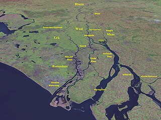
The Merwede is the name of several connected stretches of river in the Netherlands, between the cities of Woudrichem, Dordrecht and Papendrecht. The river is part of the Rhine–Meuse–Scheldt delta and is mostly fed by the river Rhine.

Nieuwe Pekela is a village in the Dutch province of Groningen. It is located in the municipality of Pekela, about 7 km southeast of Veendam. The village started as a peat colony, and was named after the river Pekel A. During the 19th century, the village was active in the maritime trade, and contains a museum dedicated to the maritime history. In December 1969, the first women strike of the Netherlands occurred in Nieuwe Pekela.

Oude Pekela is a town in the Dutch province of Groningen. It is located in the municipality of Pekela, about 5 km southwest of Winschoten. It was established to exploit the peat in the area. During the 19th century, it was known for its maritime transport. During the 20th century, Oude Pekela became the centre of the cardboard and potato starch industry.
Koedood is a hamlet in the Dutch province of South Holland. It is located on the border of the municipalities of Albrandswaard and Barendrecht.
Langebakkersoord is a former municipality in the Dutch province of South Holland. It was located northwest of Hoogvliet, on the confluence of the Oude Maas and Nieuwe Maas rivers.
Nieuw-Helvoet is a former village in the Dutch province of South Holland. It is now a neighbourhood in the north of the town of Hellevoetsluis.

The Oude Maas is a distributary of the river Rhine, and a former distributary of the river Maas, in the Dutch province of South Holland. It begins at the city of Dordrecht where the Beneden Merwede river splits into the Noord and the Oude Maas. It ends when it joins the Nieuwe Maas to form Het Scheur.

The Nieuwe Maas is a distributary of the Rhine River, and a former distributary of the Maas River, in the Dutch province of South Holland. It runs from the confluence of the rivers Noord and Lek, and flows west through Rotterdam. It ends west of the city where it meets the Oude Maas, near Vlaardingen, to form Het Scheur. After a few miles, the Scheur continues as the artificial Nieuwe Waterweg. The total length of the Nieuwe Maas is approximately 24 kilometres (15 mi).

Amsterdam-Zuid is a borough (stadsdeel) of Amsterdam, Netherlands. The borough was formed in 2010 as a merger of the former boroughs Oud-Zuid and Zuideramstel. The borough has almost 138,000 inhabitants (2013). With 8,500 homes per square kilometer, it is one of the most densely populated boroughs of Amsterdam. It has the highest income per household of all boroughs in Amsterdam.
Binnenstad is a neighborhood of Amsterdam, Netherlands located in the Centrum borough. It is divided between the Burgwallen Oude Zijde (east) and Burgwallen Nieuwe Zijde (west) areas.

Oude Pijp, also known as Noord-Pijp is a neighbourhood of Amsterdam, Netherlands located in an urbanised part of the Zuid borough. It had a population of 14,102 in 2011 and an area of 68 hectares. Together with Nieuwe Pijp, Oude Pijp forms De Pijp.

Noordereiland is a neighborhood of Rotterdam, Netherlands. The Noordereiland owes its name to the Noorderhaven which, under the leadership of C.B. van der Tak was dug between 1872 and 1874. By digging the Noorderhaven, the Noordereiland was separated from the former island of Fijenoord and is now an island between the central parts of the North and South side of the city. Until the end of the 20th century the island was inhabited by a large population of inland skippers. Part of the neighborhood is a protected cityscape.

Pekel A (also Pekel Aa; Dutch pronunciation: [ˈpeːkəl aː]) is a river in the Province of Groningen in the Netherlands. The villages of Oude Pekela and Nieuwe Pekela have been named after the river. The name translates to Brine (Pekel) River (A), and used to flow from the Dollart into a large raised bog. The Dollart was poldered from the 15th century until 1924, and the river now has its source at the confluence with the Westerwoldsche Aa at De Bult. The river was canalised and extended. The part from Oude Pekela to Stadskanaal was renamed Pekelderdiep. From 1599 until 1810, the area through which the river flowed, was a peat colony. In the 20th century, the Pekel A was a heavily polluted river, but it has been cleaned up since the 1970s.
References
- ↑ Ad van der Meer and Onno Boonstra, Repertorium van Nederlandse gemeenten , KNAW, 2011.