
Oulunsalo is former municipality in the region of Northern Ostrobothnia, in Finland. Along with Haukipudas, Kiiminki and Yli-Ii it lost its municipal status and was merged with the city of Oulu on 1 January 2013. The municipality had a population of 9,746 and covered an area of 211.22 square kilometres (81.55 sq mi) of which 127.86 km2 (49.37 sq mi) is water. The population density is 116.915/km2 (302.81/sq mi). The municipality was founded in 1882.

Yli-Ii was a municipality of Finland. It was located in the province of Oulu and was part of the Northern Ostrobothnia region. Alongside Haukipudas, Kiiminki and Oulunsalo municipalities it was merged with the city of Oulu on 1 January 2013. The municipality had a population of 2,179 and covered an area of 793.27 square kilometres (306.28 sq mi) of which 24.12 km2 (9.31 sq mi) is water. The population density was 2.8330/km2 (7.3374/sq mi).

Ylikiiminki is a former municipality of Finland. It was consolidated with the city of Oulu on 1 January 2009.
FM- and TV-mast Helsinki-Espoo is a mast located on Harmaakallio hill near Latokaski, Espoo, Finland. Its current height is 326 metres (1,070 ft).

Kiiminkijoki is a river of Finland in the region of Northern Ostrobothnia. It flows for 170 kilometres (110 mi) into the Gulf of Bothnia.

Myllytulli is a neighbourhood of the city centre area of Oulu, Finland.

Intiö is a neighbourhood of the city centre area of Oulu, Finland. It is located on the southern bank of the Oulu River in between Myllytulli and Värttö neighbourhoods.

Raksila is a neighbourhood of the city centre area of Oulu, Finland. It is bounded by the Oulu railway station to the west, the Oulu Cemetery in the Intiö neighbourhood to the north, the Finnish national road 4 to the east and the Finnish national road 22 to the south.

Pokkinen is a district of the city centre area of Oulu, Finland. Together with districts of Vaara and Vanhatulli, Pokkinen forms the central business district of Oulu. It is bounded by the estuary of the Oulujoki river to the west, the Koskikeskus and Myllytulli districts to the north, the Vaara district to the east and the Vanhatulli district to the south.

Vanhatulli is a district of the city centre area of Oulu, Finland. Together with the districts of Pokkinen and Vaara, Vanhatulli forms the central business district of Oulu. It is bounded by the estuary of the Oulujoki river to the west, the Pokkinen and Vaara districts to the north, the Leveri and Hollihaka districts to the south and the railway to the east.

Vaara is a district of the city centre area of Oulu, Finland. Together with the districts of Pokkinen and Vanhatulli, Vaara forms the central business district of Oulu. It is bounded by the districts of Raksila to the east, Pokkinen to the west, Myllytulli to the north and Vanhatulli to the south.

Haukipudas is a district of Oulu, Finland. Together with Jokikylä and Martinniemi districts, it forms the Haukipudas area. Haukipudas is located in the river delta of the Kiiminkijoki river. It is bounded by the Bothnian Bay in the west, National road 4 in the east, Martinniemi district in the north and Kello district in the south. The district was established in 2013 when the Haukipudas municipality together with Kiiminki, Oulunsalo and Yli-Ii municipalities were merged with the city of Oulu.

Kiiminki is a district of Oulu, Finland. Together with Alakylä, Hannus and Huttukylä districts, it forms the Kiiminki area. The center of the district is located where the National road 20 crosses the Kiiminkijoki river. The district was established in 2013 when the Kiiminki municipality together with Haukipudas, Oulunsalo and Yli-Ii municipalities were merged with the city of Oulu.

Kontinkangas is a district of Oulu, Finland. It is located to the east of the National road 4 and to the north of the National road 22 about two kilometers from the city centre. Its neighbouring districts are Kaukovainio, Raksila, Peltola and Oulunsuu.

Karjasilta is a district in the Höyhtyä area in the city of Oulu, Finland. The district close to the city centre is bordered by the Raksila district to the north, Finnish national road 4 to the east, the Vanhatulli and Limingantulli districts to the west and the Nokela and Höyhtyä districts to the south.

Oulujoki is a former municipality of Finland. The municipality had a population of 5,230 (1963) and covered a land area of 606.1 square kilometres (234.0 sq mi). Its neighbouring municipalities were Kempele, Kiiminki, Muhos, Oulu, Tyrnävä, Utajärvi and Ylikiiminki. The municipality was named after the river Oulujoki.

Martinniemi is a district of Oulu, Finland. Together with Haukipudas and Jokikylä districts, it forms the Haukipudas area. Martinniemi is located in north of the river delta of the Kiiminkijoki river. It is bounded by the Bothnian Bay in the west, the Jokikylä district in the east, the Ii municipality in the north and the Kiiminkijoki river and the Haukipudas district in the south. The district was established in 2013 when the Haukipudas municipality together with Kiiminki, Oulunsalo and Yli-Ii municipalities were merged with the city of Oulu.
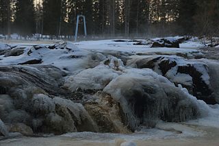
Koitelinkoski is an outdoor recreation area located along the Kiiminkijoki river in the Kiiminki district in Oulu, Finland. The area consists of small islands dividing the free-flowing river into smaller streams and rapids. The Koitelinkoski rapids stretch about three kilometers on the river. The rapids are one of the most impressive ones on the Kiiminkijoki river.


