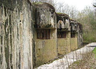
Ouvrage Latiremont is a gros ouvrage of the Maginot Line, located in the Fortified Sector of the Crusnes, sub-sector of Arrancy. It lies between the gros ouvrage Fermont and the petit ouvrage Mauvais Bois, facing Belgium. The village of Doncourt-Cités is nearby. Latiremont was active in 1939-1940, coming under direct attack in late June 1940. It surrendered to German forces on 27 June. After renovations during the Cold War, it was abandoned.

Ouvrage Hochwald is a gros ouvrage of the Maginot Line, one of the largest fortifications in the Line. Located on the Hochwald ridge in the Fortified Sector of Haguenau in the community of Drachenbronn-Birlenbach in the Bas-Rhin department of northeastern France, it was designed to protect the northern Vosges region of France. Ouvrage Hochwald is sometimes considered as two ouvrages because of its separation of the western and the eastern portions of the ouvrage. Uniquely, the original plans for the position included an elevated battery to the rear with long-range 145 mm or 155 mm gun turrets of a new kind. Hochwald is used by the French Air Force as an armoured air defense coordination center.

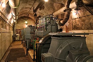
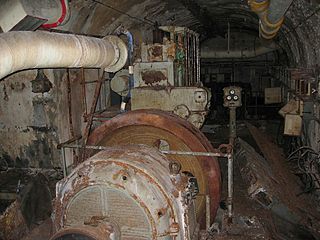
Ouvrage Hackenberg, one of the largest of the Maginot Line fortifications, is part of the Fortified Sector of Boulay. It is situated twenty kilometres east of Thionville, in the Moselle département, near the village of Veckring, on the Hackenberg. It is located between gros ouvrage Billig and petit ouvrage Coucou, facing Germany. The fort occupies the wooded Hackenberg ridge. Before World War II it was considered a showpiece of French fortification technology, and was visited by British King George VI.

Ouvrage Mont des Welches, a gros ouvrage of the Maginot Line fortifications, is part of the Fortified Sector of Boulay. It comprises two entrance blocks, one infantry block, one artillery block, one observation block and two combination blocks. It is located between petit ouvrage Coucou and gros ouvrage Michelsberg, facing Germany. Relatively small for a gros ouvrage, Mont des Welches saw a brief period of sharp action in June 1940, when German forces moving along the rear of the Maginot Line engaged the position without success. After modest renovations in the 1950s, Mont des Welches was abandoned in the 1970s.
Ouvrage Michelsberg, one of the Maginot Line fortifications, formed part of the Fortified Sector of Boulay as well as the fortified region of Metz. The ouvrage is located in Moselle (département) between the towns of Dalstein and d'Ebersviller, about 23 km from Thionville. It is located between gros ouvrage Mont des Welches and petit ouvrage Hobling, facing Germany. Michelsberg did not see significant action in the Battle of France until June 1940, when it was attacked from the rear by German forces that had bypassed the Maginot Line. It successfully resisted these attacks, but was compelled to surrender in accordance with the 25 June 1940 armistice. After the Second World War it was renovated as a Cold War fortification against a potential Soviet invasion, then abandoned. It is now operated as a museum, and may be visited.
Ouvrage Coucou is a lesser work of the Maginot Line, located in the Fortified Sector of Boulay. The ouvrage consists of two infantry blocks, and is located between the gros ouvrages of Hackenberg and Mont des Welches, facing Germany, just north of Kemplich.
Ouvrage Bousse, also known as Ouvrage Bois de Bousse, is a lesser work of the Maginot Line in the Fortified Sector of Boulay. The ouvrage is located between petit ouvrage Hobling and gros ouvrage Anzeling, near Hestroff in the Bois du Bousse, facing Germany. A small position, it was manned primarily by reservists. It is noted for the events of 15 June 1940, when it received orders to prepare for an evacuation as German forces advanced along the Line in the Battle of France. As the garrison prepared to abandon the position, sabotaging equipment, they destroyed their telephone connection, leaving them unable to receive the order countermanding the evacuation. The garrison was captured three days after leaving Bousse. Bousse is now managed as a museum and is open to public visitation.
Ouvrage Bovenberg is a lesser work of the Maginot Line. Located in the Fortified Sector of Boulay, the ouvrage is located between petits ouvrages Berenbach and Denting, facing Germany. It consists of two infantry blocks and two artillery blocks.
Ouvrage Denting is a lesser work of the Maginot Line. Part of the Fortified Sector of Boulay, the ouvrage consists of three infantry blocks, and is located between petits ouvrages Bovenberg and Village Coume, near the village of Denting in Moselle département, facing Germany. The position saw little action in World War II.

Ouvrage Coume Annexe Sud is a lesser work of the Maginot Line. Located in the Fortified Sector of Boulay, the ouvrage consists of two infantry blocks, one artillery block and one observation block, and is located between petits ouvrages Coume and Mottemberg, facing Germany.
Ouvrage Mottenberg is a lesser work of the Maginot Line. Part of the Fortified Sector of Boulay, the ouvrage consists of one entrance block and two infantry blocks, and is located between petits ouvrages Coume Annexe Sud and Kerfent, facing Germany.

Ouvrage Métrich located in the village of Kœnigsmacker in Moselle, comprises part of the Elzange portion of the Fortified Sector of Thionville of the Maginot Line. A gros ouvrage, it is the third largest of the Line, after Hackenberg and Hochwald. It lies between petit ouvrage Sentzich and gros ouvrage Billig, facing Germany. Located to the east of the Moselle, it cooperated with Ouvrage Galgenberg to control the river valley.

Ouvrage Molvange is a large work, or gros ouvrage of the Maginot Line. The fortification complex faces the France-Luxembourg border from a height near Entrange in the Moselle department. The complex, armed and occupied in 1935, is located on the heights of Entrange, at an altitude of about 400 metres (1,300 ft). Molvange is flanked by the even larger Ouvrage Rochonvillers to the west and smaller petit ouvrage Immerhof to the east, part of the Fortified Sector of Thionville. Molvange was not involved in significant combat during World War II, but due to its size it was repaired and retained in service after the war. During the Cold War, Molvange's underground barracks and former ammunition magazine became a hardened military command centre.

Ouvrage Fermont is a gros ouvrage of the Maginot Line, part of the Fortified Sector of the Crusnes in northeastern France, near the community of Montigny-sur-Chiers. It is located near the commune of Montigny-sur-Chiers, between the petit ouvrage Ferme Chappy and the gros ouvrage Latiremont. The position is near the western end of the Line, about four kilometers east of Longuyon, facing Belgium. There was significant combat at Fermont during the last stages of the Battle of France. It was repaired and reactivated during the 1950s and 1960s as a strongpoint in the event of an invasion by Soviet forces. After being abandoned by the military, it has been restored and is maintained as a museum.
Ouvrage Mauvais-Bois is a petit ouvrage of the Fortified Sector of the Crusnes on the Maginot Line. It is located between the gros ouvrage Latiremont and the petit ouvrage Bois-du-Four, facing the Belgium/Luxembourg border. The original plan for the position was for two phases of construction, resulting in a gros ouvrage provided with heavy artillery. The increase in tension between France and Germany in the late 1930s caused resources to be diverted elsewhere, and only the first three combat blocks were built. In 1940 the ouvrage was regularly bombarded, but not directly attacked by German infantry. When the French military divested itself of the majority of the Maginot fortifications, Mauvais-Bois was the second to be sold.

Ouvrage Bois-du-Four is a lesser work in the Fortified Sector of the Crusnes of the Maginot Line. The ouvrage consists of a single large combat block without an underground gallery system, and is located between petit ouvrage Mauvais-Bois and gros ouvrage Bréhain, facing Luxembourg. A planned expansion, never carried out, was intended to enlarge Bois-du-Four into a fully equipped gros ouvrage. Bois-du-Four saw little action in either the Battle of France in 1940 or the Lorraine Campaign of 1944. It is preserved by the community of Villers-la-Montagne and may be visited.
Ouvrage Bréhain is part of the Fortified Sector of the Crusnes of the Maginot Line, located near the community of Bréhain-la-Ville in the Meurthe-et-Moselle department of France. Bréhain is flanked by petits ouvrages Mauvais Bois and Aumetz. The gros ouvrage was equipped with long-range artillery, and faced the border with Luxembourg. It saw no major action in either the Battle of France in 1940 or the Lorraine Campaign of 1944. While not open to public visitation, it has been secured and is in relatively good condition when compared to other abandoned Maginot positions. A flanking casemate has been restored and may be visited.
Ouvrage Soetrich is a gros ouvrage of the Maginot Line in north-eastern France. Soetrich is located between petits ouvrages Immerhof and Bois Karre, facing the France-Luxembourg border near the town of Hettange-Grande, part of the Fortified Sector of Thionville. Compared with other gros ouvrages, Soetrich is compact in arrangement, with the entries and underground ammunition magazines and barracks in close proximity to the combat blocks, accessed through underground galleries at an average depth of 30 metres (98 ft). Its primary purpose was to cover the main road to Luxembourg, just to the west. Along with its neighbours, Ouvrage Rochonvillers and Ouvrage Molvange, Soetrich was used during the Cold War as a secure command centre for NATO forces.
Ouvrage Vélosnes is a gros ouvrage of the Maginot Line, located in the Fortified Sector of Montmédy between the towns of Othe and Vélosnes, facing Belgium. It possesses four combat blocks and one entrance block. It is located to the east of petit ouvrage Thonnelle. The position was sabotaged and abandoned by French forces that were ordered to retreat from the exposed position in June 1940 during the Battle of France. The ouvrage is abandoned and is administered as a nature preserve.

Ouvrage Chesnois, also known as Ouvrage Chênois, is a gros ouvrage of the Maginot Line, located in the Fortified Sector of Montmédy, facing Belgium. The ouvrage lies between the towns of Montlibert and Thonne-le-Thil. It possesses six combat blocks. It is located between gros ouvrage Thonnelle and petit ouvrage La Ferté. The position was sabotaged and abandoned by French forces that were ordered to retreat from the exposed position in June 1940 during the Battle of France. The ouvrage is now abandoned and sealed.

