
Mornington Crescent is a London Underground station in Somers Town in north west London, named after the nearby street. The station is on the Charing Cross branch of the Northern line, between Camden Town and Euston stations. It is in Travelcard Zone 2.
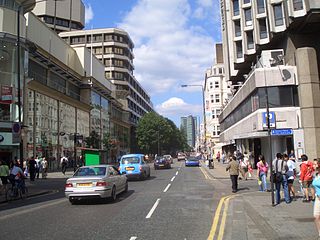
The A400 road is an A road in London that runs from Charing Cross to Archway in North London. It passes some of London's most famous landmarks.
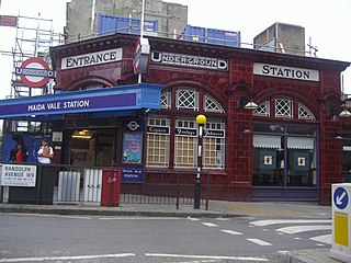
Randolph Avenue is a street in Maida Vale in London. Located in the City of Westminster, it is a long avenue running from north to south. The southern end is located in Little Venice near to the Paddington branch of the Grand Union Canal. The street runs northwards, crossing Clifton Gardens, Sutherland Avenue, Elgin Avenue and Carlton Vale. The road then continues as Randolph Gardens until it meets Kilburn Park Road. The Edgware Road runs directly parallel to Randolph Avenue to the east.

Gloucester Avenue is a street in the Primrose Hill area of London, England. Located in the London Borough of Camden, it is a residential road featuring many nineteenth century properties including several pubs as well as the neo-Georgian Cecil Sharp House. For much of its route it runs adjacent to the West Coast Main Line out of Euston Station.

Pond Street is located in Hampstead in the London Borough of Camden. It runs eastwards from Rosslyn Hill to South End Green, located in the old "South End" of the settlement. The street takes its name from an ancient pond at South End Green, a source of the River Fleet, and has been known by this name since at least 1678. The pond survived into the Victorian era.
Hampstead Way is a street at the northern edge of Hampstead. It is located primarily in the London Borough of Barnet although its southern end forms a border with the London Borough of Camden in which the rest of Hampstead is located. In the south it is part of the old hamlet of North End, which marked the northern boundary of Hampstead, but then curves northwards and follows the edge of Hampstead Heath into Golders Green and Hampstead Garden Suburb. The southern end leads off North End Way.

Hampstead Grove is a street in Hampstead in the London Borough of Camden. It heads northwards from Holly Hill running towards Hampstead Heath, but curving back towards Lower Terrace which connects it to the Heath. It runs roughly parallel to Heath Street to its east. It takes its name from the groves of trees that marked the landscape.
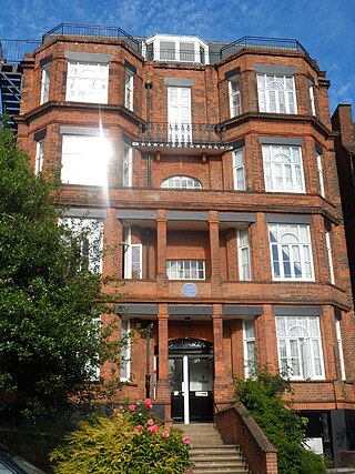
Holly Hill is a street in Hampstead in the London Borough of Camden. It runs northwards from a junction with Hampstead High Street and Heath Street, Hampstead heading uphill to a grassy triangle named Holly Bush Hill where it meets Windmill Hill and Hampstead Grove by the entrance to Fenton House. It takes its name from a grove of holly bushes which stood on the hill until the 1940s. In the eighteenth century it was known as Cloth Hill, likely because local laundresses using Hampstead Wells hung their clothes out on the Holly Bushes to dry. Holly Mount turns eastwards off the street and forms a cul-de-sac, although there are steps linking it to Heath Street below. Holly Mount contains The Holly Bush pub, which was once linked to the nearby assembly rooms. Notable residents of Holly Hill have included the artists George Romney and Derek Hill, both commemorated with blue plaques. A number of properties are now Grade II listed. Romney's House at 5 Holly Bush Hill is Grade I listed. Running uphill to the west is Mount Vernon which also features notable historic properties and Holly Walk.
Netherhall Gardens is a street in Hampstead, in the London Borough of Camden. It connects Finchley Road with Fitzjohns Avenue, curving twice along its route and meeting Nutley Terrace and Maresfield Gardens. The short Netherhall Way connects it to Frognal. Belsize Tunnel carrying the Midland Main Line passes under the street.

Adelaide Road is a street in London running east to west between Chalk Farm and Swiss Cottage. Located in the London Borough of Camden it is part of the longer B509 route which continues as Belsize Road through South Hampstead. The Belsize Park area of Hampstead is to its north while Primrose Hill is to the south. It runs parallel to Fellows Road and Eton Avenue. Along its route it meets or is crossed by several streets including Primrose Hill Road and Avenue Road. At its eastern end is Chalk Farm tube station at the junction with Haverstock Hill, which opened in 1907. It takes its name from Queen Adelaide, wife of William IV.

Priory Road is a street in Kilburn. Located in the London Borough of Camden it runs northwards from Belsize Road through South Hampstead crossing several streets including Abbey Road before finishing at a junction with Broadhurst Gardens, not far from West Hampstead tube station. It takes its name from the old Kilburn Priory located in the area until the dissolution of the monasteries under Henry VIII.

Branch Hill is a street in Hampstead. Located in the London Borough of Camden it is named after a hill on Hampstead Heath and runs adjacent to the heath between Frognal Rise and West Heath Road. Branch Hill, then largely open countryside, was a favourite landscape of the artist John Constable and he painted it on a number of occasions. Branch Hill Pond is located close to the junction with West Heath Road, while it dried up in the early twentieth century recent efforts have been made to restore it.

Blomfield Road is a street in the Maida Vale area of Central London. Located in the London Borough of Westminster it runs on the northern bank of the Regent's Canal in Little Venice. The road branches westwards off the A5 and runs directly along the canal with both Randolph Avenue and Warwick Avenue running north off it. It then follows the canal by turning sharply northwards until it meets with Formosa Street.

Fitzjohns Avenue is a street in Hampstead, England. Located in the London Borough of Camden it runs northwards from College Crescent to join and become Heath Street in Hampstead Village. Running steeply uphill for much of its route Fitzjohns Avenue is joined or crossed by various other streets including Belsize Park, Belsize Lane, Maresfield Gardens, Netherhall Gardens, Akenfield Road and Lyndhurst Road. It is classified as part of the B511 road. It is also sometimes written as Fitzjohn's Avenue.

Fitzroy Road is a street in the Primrose Hill area of London. Located in the London Borough of Camden, it is a residential road lined with Victorian era houses. It runs roughly northeastwards from Regent's Park Road at the edge of Primrose Hill to Gloucester Avenue. Fitzroy Road is crossed around halfway along its route by Chalcot Road that links it to Chalcot Square to the north. The Princess of Wales pub stands at the corner with Chalcot Road.

Parkway is a street in the London Borough of Camden. It runs roughly westwards from the Britannia Junction with Camden High Street and other streets in the centre of Camden Town to the entrance to Regent's Park near Gloucester Gate. It meets or is crossed by streets including Arlington Road, Albert Street, Delancey Street, Gloucester Avenue, and Albany Street. From Britannia Junction at the eastern end by Camden Town tube station, Camden Road and Kentish Town Road run northwards. It forms part of the A4201 route, which includes many streets starting at Piccadilly Circus, continues along Albany Street, and ends with Parkway at Britannia Junction. It is primarily a commercial street with bars, shops and restaurants.

Delancey Street is a mainly residential street in Camden Town, London, England. Located in the London Borough of Camden, it runs roughly west to east in a curve from Camden High Street to Parkway. It is met or crossed by Arlington Road, Albert Street, Gloucester Avenue, and Mornington Terrace. Eastwards of Camden High Street the route continues as Pratt Street as far as the Regent's Canal.

Mornington Terrace is a street in Camden Town. Located in the London Borough of Camden, it runs southeastwards from Delancey Street following the route of the main line into Euston that runs immediately to its west. At its southern end it becomes Clarkson Row while Mornington Place connects it to Mornington Crescent. Both Mornington Terrace and Place are notable for their surviving Victorian houses.

Lyndhurst Road is a residential street in the Belsize Park area of Hampstead. Located in the London Borough of Camden it runs west to east, linking Fitzjohns Avenue to Rosslyn Hill. Until the nineteenth century it was a rural area on the outskirts of the capital, occupied by Rosslyn House and its estate. As London expanded the Rosslyn House estate, as well as nearby Belsize House, were redeveloped into residential streets. The oldest stretch of Lyndhurst Road was laid out in 1862. It follows the route of Chestnut Walk a much older approach towards Rosslyn House.

Highgate West Hill is a street in Highgate, London. Located in the London Borough of Camden it runs north to south with Hampstead Heath off to its west and Highgate Cemetery away to the east. A number of streets run off the road including The Grove, Millfield Lane and Hillway. The route dates back to the medieval era.


