
A tabard is a type of short coat that was commonly worn by men during the late Middle Ages and early modern period in Europe. Generally worn outdoors, the coat was either sleeveless or had short sleeves or shoulder pieces. In its more developed form it was open at the sides, and it could be worn with or without a belt. Though most were ordinary garments, often work clothes, tabards might be emblazoned on the front and back with a coat of arms (livery), and in this form they survive as the distinctive garment of officers of arms.

Mayfair is an affluent area in the West End of London towards the eastern edge of Hyde Park, in the City of Westminster, between Oxford Street, Regent Street, Piccadilly and Park Lane. It is one of the most expensive districts in the world.

The Honourable Society of the Middle Temple, commonly known simply as Middle Temple, is one of the four Inns of Court exclusively entitled to call their members to the English Bar as barristers, the others being the Inner Temple, Gray's Inn and Lincoln's Inn. It is located in the wider Temple area of London, near the Royal Courts of Justice, and within the City of London. As a liberty, it functions largely as an independent local government authority.

The Honourable Society of Lincoln's Inn is one of the four Inns of Court in London to which barristers of England and Wales belong and where they are called to the Bar. Lincoln's Inn, along with the three other Inns of Court, is recognised as being one of the world's most prestigious professional bodies of judges and lawyers.
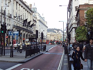
Piccadilly is a road in the City of Westminster, London, to the south of Mayfair, between Hyde Park Corner in the west and Piccadilly Circus in the east. It is part of the A4 road that connects central London to Hammersmith, Earl's Court, Heathrow Airport and the M4 motorway westward. St James's is to the south of the eastern section, while the western section is built up only on the northern side. Piccadilly is just under 1 mile (1.6 km) in length, and it is one of the widest and straightest streets in central London.
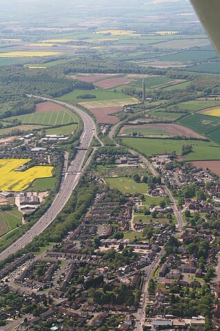
Stokenchurch is a village and civil parish in south-west Buckinghamshire, England. It is located in the Chiltern Hills, about 3 miles (5 km) south of Chinnor in Oxfordshire and 6 miles (10 km) west of High Wycombe. Stokenchurch is a commuter village, served by junction 5 of the M40 motorway to London, Oxford and Birmingham. The Stokenchurch BT Tower, to the west of the village, is a highly visible landmark on the edge of the Chilterns and pinpoints the village's location for miles ahead.

The White Hart was the personal badge of Richard II, who probably derived it from the arms of his mother, Joan "The Fair Maid of Kent", heiress of Edmund of Woodstock. It may also have been a pun on his name, as in "Rich-hart". In the Wilton Diptych, which is the earliest authentic contemporary portrait of an English king, Richard II wears a gold and enamelled white hart jewel, and even the angels surrounding the Virgin Mary all wear white hart badges. In English Folklore, the white hart is associated with Herne the Hunter.

Theale is a village and civil parish in West Berkshire, England, 5 miles (8 km) southwest of Reading and 10 miles (16 km) east of Thatcham. The compact parish is bounded to the south and south-east by the Kennet & Avon Canal, to the north by a golf course, to the east by the M4 motorway and to the west by the A340 road. The village's history is a good example of how different modes of transport have achieved dominance in England over the last three centuries, from road to canal to railway and back to road again.

Steeple Aston is a village and civil parish on the edge of the Cherwell Valley, in the Cherwell District of Oxfordshire, England, about 12 miles (19 km) north of Oxford, 7 miles (11 km) west of Bicester, and 10 miles (16 km) south of Banbury. The 2011 Census recorded the parish population as 947. The village is 108 metres (354 ft) above sea level. The River Cherwell and Oxford Canal pass 1 mile (2 km) east of the village. The river forms part of the eastern boundary of the parish. The parish's southern boundary, 1⁄2 mile (800 m) south of the village, also forms part of Cherwell District's boundary with West Oxfordshire.

Northleach is a market town and former civil parish, now in parish Northleach with Eastington, in the Cotswold district, in Gloucestershire, England. The town is in the valley of the River Leach in the Cotswolds, about 10 miles (16 km) northeast of Cirencester and 11 miles (18 km) east-southeast of Cheltenham. The 2011 Census recorded the parish's population as 1,854, the same as Northleach built-up-area.

Piddington is a hamlet in the parish of Piddington and Wheeler End in Buckinghamshire, England. It is located on the main A40 between Stokenchurch and West Wycombe.

Deddington is a civil parish and small town in Oxfordshire about 6 miles (10 km) south of Banbury. The parish includes two hamlets: Clifton and Hempton. The 2011 Census recorded the parish's population as 2,146. Deddington is a small settlement but has a commercial centre including a market place, which hosts a popular monthly farmer’s market. It has been a market town probably since the 12th century. One of the Hundred Rolls of King Edward I from 1275–76 records Deddington as a borough. It has a deli, coffee shop, restaurant, three pubs and a town hall. Its football team is called Deddington Town FC.

Market Street is a street in central Oxford, England, running east to west.
The Green Man and Still was a tavern in Oxford Street, London. It was much favoured during the 18th and 19th centuries by cricketers playing at the nearby Thomas Lord's grounds, including as William Beldham, Tom Walker and David Harris, and was also patronised by the leading bookmakers of the day.
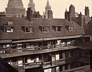
The Society for Photographing Relics of Old London was founded in 1875 in London, England, initially with the purpose of recording the Oxford Arms, a traditional galleried public house on Warwick Lane that was to be demolished as part of the redevelopment of the Old Bailey.

The Swan with Two Necks was a coaching inn in the City of London that, until the arrival of the railways, was one of the principal departure points for travel to the north of England from London. Its site was given over in the early 1860s to a goods and parcels depot for a firm of railway agents and carriers.

The Bull and Mouth Inn was a coaching inn in the City of London that dated from before the Great Fire of London in 1666. It was located between Bull and Mouth Street in the north and Angel Street in the south. It was once an important arrival and departure point for coaches from all over Britain, but particularly for the north of England and Scotland. It became the Queen's Hotel in 1830 but was demolished in 1887 or 1888 when new post office buildings were built in St Martin's Le Grand.

Public houses, popularly known as pubs, are a significant feature of the history and culture of the English seaside resort of Brighton. The earliest pubs trace their history back to the 16th and 17th centuries, when present-day Brighton was a fishing village. Several coaching inns were founded in the 18th century as transport improved and communications with other towns developed, and around the same time other pubs became established in the fashionable Old Steine area in Brighton's early years as a resort. Many new pubs, originally beerhouses, were established after an Act of Parliament in 1830 loosened restrictions; two of these "Beerhouse Act" pubs remain in business. In the following decade the opening of Brighton's railway station provided another major boost to the pub trade, and by the late 19th century there were nearly 800 licensed venues in the town. Numbers declined gradually—as late as 1958 there was said to be "one pub for every day of the year"—and by the early 21st century around 300 pubs were still trading, with others having closed but surviving in alternative use.

