
Zittau is the southeasternmost city in the German state of Saxony, and belongs to the district of Görlitz, Germany's easternmost district.

Herrnhut is a town of around 6,000 inhabitants in Upper Lusatia, in the district of Görlitz, in eastern Saxony, Germany. The town is mainly known as the place of origin of the community of the Moravian Church, and of the Moravian Stars.

The Zittau–Oybin/Jonsdorf railway, or Zittau–Kurort Oybin/Kurort Jonsdorf narrow-gauge railway, is a narrow-gauge railway system employing steam locomotives and serving the mountain health-spa resorts of Oybin and Jonsdorf in the Zittau Mountains in southeast Saxony (Germany). The track gauge is 750 mm.

Upper Lusatia is a historical region in Germany and Poland. Along with Lower Lusatia to the north, it makes up the region of Lusatia, named after the Slavic Lusici tribe. Both parts of Lusatia are home to the West Slavic minority group of the Sorbs.
The Lusatian Mountains are a mountain range of the Western Sudetes on the southeastern border of Germany with the Czech Republic. They are a continuation of the Ore Mountains range west of the Elbe valley. The mountains of the northern, German, part are called the Zittau Mountains.

The community of Jonsdorf is located in the south of the Kreis Görlitz in the southeast of the German federal state of Saxony. It is embedded into a valley of the Zittau Mountains, part of the Lusatian Mountains.

Oybin is a municipality in the Görlitz district, in Saxony, Germany, located very close to the border of the Czech Republic. Following the defeat of the Protestant armies by the Habsburgs in the Battle of the White Mountain in 1620, many Protestant Czechs found refuge across the border in the hills of Upper Lusatia. It is a "Kurort", a resort or spa certified by the state, where people go for rest and recuperation. It is most famous for its mountain of the same name, an exposed natural sandstone dome that towers above the town. The ruins of a medieval monastery lend a wild romantic beauty to it and it was a favorite subject of 19th-century Romantic painters like Caspar David Friedrich. Many bizarrely shaped geological rock formations can be found in the surroundings. The scenic narrow gauge Zittau–Kurort Oybin/Kurort Jonsdorf railway runs from Oybin to Bertsdorf, from there to the neighboring municipality of Jonsdorf and the town of Zittau. Oybin municipality has 3 districts: Oybin, Hain and Lückendorf.

The Saxon-Upper Lusatian Railway Company is a German railway company based in Saxony. It is the owner and operator of the Zittau narrow gauge railway.

Arakelots Monastery is a 13th-century monastery about 3 kilometres (2 mi) southwest of the village of Kirants in the Tavush Province of Armenia. The monastic complex sits upon the crest of a hill surrounded by a dense forest on the left bank of the Kunen River.

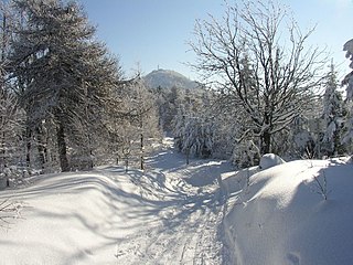
The Zittau Mountains, formerly also called the Lusatian Ridge, refer to the German part of the Lusatian Mountains that straddle the Saxon-Bohemian border in the extreme southeast of the German state of Saxony.
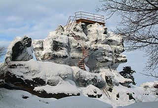
Mount Töpfer is a mountain with an elevation of 582 metres near the municipality of Oybin in the German state of Saxony. It is situated in the Zittau Mountains which are part of the Lusatian Mountains. It is known for it interesting rock formations near the top. Its name Töpfer (English: Potter) was probably derived from the peak that resembles two chalices.

The Zittau Mountains Nature Park is a nature park in Germany, created in 2008.

Petrus Zwicker was an East Prussian Inquisitor and cleric of the Roman Catholic Order of the Celestines. Between 1391 and 1403, he led one of the largest inquisitorial operations in the German-speaking world. The victims of this persecution of heretics, in Austria, Pomerania, Brandenburg and Hungary, were almost exclusively Waldensians. The Inquisition records of this period are today only represented by a few fragments.

The Kelchstein is a mushroom rock in the Zittau Mountains near Oybin in the German state of Saxony.
Geochores are relatively large landscape areas with similar – but owing to their size not fully uniform – characteristics. They therefore consist of a tapestry of smaller landscape units, which can be hierarchically grouped:

Zittau station is a railway station in Zittau, Germany. The station is located on the Liberec–Zittau, Zittau–Löbau and Zittau–Hagenwerder standard gauge lines as well as it is one terminus of narrow gauge Zittau–Kurort Oybin/Kurort Jonsdorf railway. Until 1945 narrow gauge Zittau–Hermsdorf railway to today's Bogatynia in Poland and Heřmanice in the Czech Republic also began at Zittau station.

Milštejn are the remaining ruins of a castle in the north of the Czech Republic. The ruins are located in the Lusatian Mountains at an altitude of 562 m, about 3.5 km north from the town of Cvikov. The exact date when the castle was built is unknown. Based on the surrounding sites, it is assumed that the castle was founded between the 13th and 14th centuries to protect the country trail leading from Lípa to Zittau. The first known owners of the castle were Berka of Dubá, a prominent cadet branch of a Bohemian noble family.

Otto Carl Alfred Moschkau (1848-1912) was a German philatelist and local historian. In 2021 he was retrospectively named as one of the fathers of philately.
Chval of Lipá was a Czech nobleman from the Ronovci family and the founder of the family of the Lords of Lipá.
This page is based on this
Wikipedia article Text is available under the
CC BY-SA 4.0 license; additional terms may apply.
Images, videos and audio are available under their respective licenses.


 Remains of the castle
 Remains of the monastery
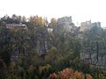 Oybin with restaurant and ruins of the monastery and castle
 Remains of the church
 Caspar David Friedrich: "Der Träumer - Klosterruine Oybin" (1835)


