The oystercatchers are a group of waders forming the family Haematopodidae, which has a single genus, Haematopus. They are found on coasts worldwide apart from the polar regions and some tropical regions of Africa and South East Asia. The exceptions to this are the Eurasian oystercatcher, the South Island oystercatcher, and the Magellanic oystercatcher, which also breed inland, far inland in some cases. In the past there has been a great deal of confusion as to the species limits, with discrete populations of all black oystercatchers being afforded specific status but pied oystercatchers being considered one single species.
The Eurasian oystercatcher also known as the common pied oystercatcher, or palaearctic oystercatcher, or just oystercatcher, is a wader in the oystercatcher bird family Haematopodidae. It is the most widespread of the oystercatchers, with three races breeding in western Europe, central Eurosiberia, Kamchatka, China, and the western coast of Korea. No other oystercatcher occurs within this area. The extinct Canary Islands oystercatcher, formerly considered a distinct species, may have actually been an isolated subspecies or distinct population of the Eurasian oystercatcher.

The black oystercatcher is a conspicuous black bird found on the shoreline of western North America. It ranges from the Aleutian Islands of Alaska to the coast of the Baja California peninsula.

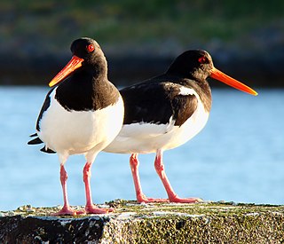
The American oystercatcher, occasionally called the American pied oystercatcher, is a member of family Haematopodidae. Originally called the "sea pie", it was renamed in 1731 when naturalist Mark Catesby observed the bird eating oysters. The current population of American oystercatchers is estimated to be 43,000. There are estimated to be 1,500 breeding pairs along the Atlantic and Gulf Coasts of the US. The bird is marked by its black and white body and a long, thick orange beak.

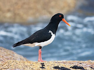
The pied oystercatcher is a species of oystercatcher. It is a wading bird native to Australia and commonly found on its coastline. The similar South Island pied oystercatcher occurs in New Zealand.

The sooty oystercatcher is a species of oystercatcher. It is a wading bird endemic to Australia and commonly found on its coastline. It prefers rocky coastlines, but will occasionally live in estuaries. All of its feathers are black. It has a red eye, eye ring and bill, and pink legs.

The Canary Islands oystercatcher, Canarian oystercatcher, or Canarian black oystercatcher , was a shorebird of uncertain taxonomy endemic to Fuerteventura, Lanzarote, and their offshore islets in the Canary Islands, Spain. It is now considered to be extinct.

The South Island oystercatcher or South Island pied oystercatcher is one of the two common oystercatchers found in New Zealand. Its name is often contracted to the acronym "SIPO". The indigenous Māori name is tōrea. The scientific name commemorates the German ethnographer, naturalist and colonial explorer Friedrich Hermann Otto Finsch.
The Anderson Island, also known as Woody Island, part of the Tin Kettle Island Group of the Furneaux Group, is a 166-hectare (410-acre) granite island, located in Bass Strait, lying northeast of Tasmania, in south-eastern Australia. Anderson Island lies between Flinders and Cape Barren Islands and is partly a pastoral lease used for grazing sheep and cattle. The island is joined at low tide to nearby Little Anderson and Tin Kettle Islands by extensive intertidal mudflats. The island is supposed to be named after John Anderson, a sealer living on the island by 1842.
Little Anderson Island is an island, with an area of 13 ha, in south-eastern Australia. It is part of Tasmania’s Tin Kettle Island Group, lying in eastern Bass Strait between Flinders and Cape Barren Islands in the Furneaux Group. The island is joined at low tide to nearby Anderson and Tin Kettle Islands by extensive intertidal mudflats. The island is part of the Franklin Sound Islands Important Bird Area, identified as such by BirdLife International because it holds over 1% of the world populations of six bird species.

Tin Kettle Island is a long, sandy island, with an area of 176 ha, in south-eastern Australia. It is part of Tasmania’s Tin Kettle Island Group, lying in eastern Bass Strait between Flinders and Cape Barren Islands in the Furneaux Group. The island is joined at low tide to nearby Anderson and Little Andersons by extensive intertidal mudflats. The island is farmed, mainly cattle grazing. The island is part of the Franklin Sound Islands Important Bird Area, identified as such by BirdLife International because it holds over 1% of the world populations of six bird species.
Samphire Island is a small shell-grit island, with an area of 3.3 ha, in south-eastern Australia. It is part of Tasmania’s Great Dog Island Group, lying in eastern Bass Strait between Flinders and Cape Barren Islands in the Furneaux Group. It is surrounded by mudflats at low tide.

The Cat Island, part of the Babel Group within the Furneaux Group, is a 39-hectare (96-acre) unpopulated granite island, located in Bass Strait, lying off the east coast of Flinders Island, Tasmania, south of Victoria, in south-eastern Australia.

Inner Sister Island, part of the Sister Islands Conservation Area, is a granite and dolerite island, with an area of 748 hectares (2.89 sq mi), located in Bass Strait, Tasmania, Australia.
The Big Green Island, part of the Big Green Group within the Furneaux Group, is a 122-hectare (300-acre) granite island with limestone and dolerite outcrops, located in Bass Strait west of Flinders Island, in Tasmania, in south-eastern Australia. The island is partly contained within a nature reserve with the rest being used for farming; and is part of the Chalky, Big Green and Badger Island Groups Important Bird Area.

The Chalky Island, part of the Big Green Group within the Furneaux Group, is a 41-hectare (100-acre) unpopulated granite island with limestone outcrops and dolerite dykes, located in the Bass Strait, west of the Flinders Island, in Tasmania, in south-eastern Australia. The island is contained within a conservation area and is part of the Chalky, Big Green and Badger Island Groups Important Bird Area.
The Isabella Island, part of the Big Green Group within the Furneaux Group, is a 11.4-hectare (28-acre) unpopulated granite island, located in the Bass Strait, west of the Flinders Island and south of Chalky Island, in Tasmania, in south-eastern Australia. The island is a nature reserve and is part of the Chalky, Big Green and Badger Island Groups Important Bird Area.
Sloping Island, incorporating the adjacent Sloping Reef, is an island nature reserve, with an area of 117 ha, in Tasmania in south-eastern Australia. It is part of the Sloping Island Group, lying close to the south-eastern coast of Tasmania around the Tasman and Forestier Peninsulas.

Louisa Island is an island with a short sandy tombolo, located adjacent to the south-western coast of Tasmania, Australia. The irregularly shaped 23-hectare (0.089 sq mi) island is part of the Maatsuyker Islands Group, and comprises part of the Southwest National Park and the Tasmanian Wilderness World Heritage Site.
Hobbs Island, also known as Green Island, is an unpopulated island located close to the south-western coast of Tasmania, Australia. Situated some 1 kilometre (0.62 mi) north of where the mouth of Port Davey meets the Southern Ocean, the 9.7-hectare (24-acre) island is part of the Trumpeter Islets Group, and comprises part of the Southwest National Park and the Tasmanian Wilderness World Heritage Site.
