More Information
A website with PTAAGMB results reported from 9 different glaciers, 5 of which are compared with available manual measurements, can be seen at www.ptaagmb.com.

PTAAGMB (Precipitation-Temperature-Area-Altitude Glacier Mass Balance)
The PTAAGMB Model is used for calculating a glacier's mass balance, the primary indicator of its health, and plots the changes to its mass balance over time to predict its future.
Developed in the mid-1990s by glaciologist Wendell Tangborn, the PTAAGMB model provides an easy and reliable alternative to the challenging task of manually measuring glaciers using snow pits and ablation stakes.
The PTAAGMB model only requires data from the precipitation and temperature (PT) observations from nearby low-altitude weather stations and the glacier's area-altitude (AA) distribution.
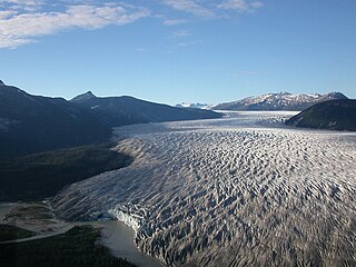
Glaciers are ultra-sensitive to minute changes in the climate and respond by changing their size and by advancing or retreating. The mass balance, or the difference between snow accumulation and snow and ice ablation, is crucial to glacier health and its survival. The Columbia Glacier in Alaska is a large tidewater glacier that began a drastic retreat in the 1970s due to climate fluctuations and began discharging large quantities of icebergs into Prince William Sound. These icebergs were responsible for a massive oil spill in 1989 when an oil tanker captain tried to avoid them and went aground. [1]
The key to the PTAAGMB model is the glacier’s area-altitude distribution, which is simply the glacier’s surface area as a function of elevation. The AA profile is a unique feature of a glacier that has been shaped by thousands of years of erosion of the bedrock underlying the glacier. Thus, the area altitude distribution has embedded within it the past climate history that has formed the glacier.
The PTAAGMB model uses daily values of such balance variables as snowline altitude, zero balance altitude, glacier balance, balance flux and the accumulation area ratio are correlated throughout the ablation season using two-degree polynomial regressions to obtain the lowest fitting error. When the minimum average error (or maximum R2) is attained, the generated balances and other variables are considered to be real. A simplex optimization technique is used to determine the optimal coefficient values that are used in algorithms to convert meteorological observations to snow accumulation and snow and ice ablation. [2]
The PTAAGMB model has been used successfully on a number of glaciers in various parts of the world: in the United States, the Alaskan glaciers Bering, Gulkana, Lemon Creek, Mendenhall, Wolverine and Wrangell Range; in Washington State, on the South Cascade Glacier; in Europe, the Austrian glaciers Hintereisferner, Kesselwanferner and Vernagt Ferner.
The mass balance and runoff of Langtang Glacier in Nepal was determined with the PTAAGMB model using daily meteorological observations observed at Kathmandu. This is the only Himalayan glacier for which mass balance and runoff have been calculated. [3]
Another feature of the PTAAGMB model is the capability to estimate glacier thickness from ice flow velocity and mass balance measurements. [4] The average thickness of South Cascade Glacier was found to be 83 meters in 1965, based on flow velocity and balance measurements. Borehole depth measurements of the glacier made later approximately agree with this estimate.
The mass balance, runoff and surges of Bering Glacier were calculated with the PTAAGMB model using weather observations at Cordova and Yakutat, Alaska. Ice volume loss measured with the PTAAGMB model agrees within 0.8% of the loss measured with the geodetic method. Runoff from Bering Glacier (derived from simulated ablation and rain) correlates with four of the glacier surges that have occurred since 1951. [5]
Comparison of glacier mass balance by glaciological, hydrological and mapping methods revealed that glaciers internally store a significant amount of liquid water. [6] Stored water in glaciers is now considered the key to understanding the disintegration of Antarctic and Greenland Ice Caps.
A website with PTAAGMB results reported from 9 different glaciers, 5 of which are compared with available manual measurements, can be seen at www.ptaagmb.com.

Snow comprises individual ice crystals that grow while suspended in the atmosphere—usually within clouds—and then fall, accumulating on the ground where they undergo further changes. It consists of frozen crystalline water throughout its life cycle, starting when, under suitable conditions, the ice crystals form in the atmosphere, increase to millimeter size, precipitate and accumulate on surfaces, then metamorphose in place, and ultimately melt, slide or sublimate away.

The cryosphere is an umbrella term for those portions of Earth's surface where water is in solid form. This includes sea ice, ice on lakes or rivers, snow, glaciers, ice caps, ice sheets, and frozen ground. Thus, there is a overlap with the hydrosphere. The cryosphere is an integral part of the global climate system. It also has important feedbacks on the climate system. These feedbacks come from the cryosphere's influence on surface energy and moisture fluxes, clouds, the water cycle, atmospheric and oceanic circulation.

Glaciology is the scientific study of glaciers, or, more generally, ice and natural phenomena that involve ice.

Ablation is the removal or destruction of something from an object by vaporization, chipping, erosive processes, or by other means. Examples of ablative materials are described below, including spacecraft material for ascent and atmospheric reentry, ice and snow in glaciology, biological tissues in medicine and passive fire protection materials.

The climatic snow line is the boundary between a snow-covered and snow-free surface. The actual snow line may adjust seasonally, and be either significantly higher in elevation, or lower. The permanent snow line is the level above which snow will lie all year.

Crucial to the survival of a glacier is its mass balance of which surface mass balance (SMB), the difference between accumulation and ablation. Climate change may cause variations in both temperature and snowfall, causing changes in the surface mass balance. Changes in mass balance control a glacier's long-term behavior and are the most sensitive climate indicators on a glacier. From 1980 to 2012 the mean cumulative mass loss of glaciers reporting mass balance to the World Glacier Monitoring Service is −16 m. This includes 23 consecutive years of negative mass balances.

The retreat of glaciers since 1850 is a well-documented effect of climate change. The retreat of mountain glaciers provide evidence for the rise in global temperatures since the late 19th century. Examples include mountain glaciers in western North America, Asia, the Alps in central Europe, and tropical and subtropical regions of South America and Africa. Since glacial mass is affected by long-term climatic changes, e.g. precipitation, mean temperature, and cloud cover, glacial mass changes are one of the most sensitive indicators of climate change. The retreat of glaciers is also a major reason for sea level rise. Excluding peripheral glaciers of ice sheets, the total cumulated global glacial losses over the 26 years from 1993 to 2018 were likely 5500 gigatons, or 210 gigatons per year.

Ablation zone or ablation area refers to the low-altitude area of a glacier or ice sheet below firn with a net loss in ice mass due to melting, sublimation, evaporation, ice calving, aeolian processes like blowing snow, avalanche, and any other ablation. The equilibrium line altitude (ELA) or snow line separates the ablation zone from the higher-altitude accumulation zone. The ablation zone often contains meltwater features such as supraglacial lakes, englacial streams, and subglacial lakes. Sediments dropped in the ablation zone forming small mounds or hillocks are called kames. Kame and kettle hole topography is useful in identifying an ablation zone of a glacier. The seasonally melting glacier deposits much sediment at its fringes in the ablation area. Ablation constitutes a key part of the glacier mass balance.
The tidewater glacier cycle is the typically centuries-long behavior of tidewater glaciers that consists of recurring periods of advance alternating with rapid retreat and punctuated by periods of stability. During portions of its cycle, a tidewater glacier is relatively insensitive to climate change.
The International Association of Cryospheric Sciences (IACS) is the eighth association of the International Union of Geodesy and Geophysics (IUGG). It was launched by the IUGG Council on 4 July 2007, developing from the International Commission of Snow and Ice of the International Association of Hydrological Sciences (IAHS) via the transitional Union Commission for the Cryospheric Sciences (UCCS).
Mark Dyurgerov was an internationally known glaciologist and Fellow of the Institute of Arctic and Alpine Research (INSTAAR) of the University of Colorado at Boulder. He was born in Moscow, Russia; both of his parents were engineers, and his mother was also a Russian poet.

The Tarfala research station is a field station of Stockholm University. The station is situated in the Tarfala Valley in northern Sweden. It specializes in glacial, periglacial and climatological research.

Gulkana Glacier is a glacier that flows from the ice fields of the south flank of the eastern Alaska Range. It is accessible by gravel roads from the Richardson Highway near mile post 197 at the Richardson Monument, just two miles north of Summit Lake and 12 miles north of Paxson and the junction with Denali Highway. Closer to the glacier, a suspension bridge allows pedestrians to cross over Phelan Creek. Wildlife includes moose and bears. The peak of a hill just southwest of Gulkana Glacier has a post labeled PEWE 1975. The Arctic Man competition takes place near Gulkana Glacier every spring.
Wendell Tangborn was an American glaciologist specializing in glacier mass balance measurements since 1960, chiefly within the states of Washington and Alaska of the Pacific Northwest.

Eklutna Glacier is a land terminating glacier in Chugach State Park and the Chugach Mountains near Anchorage, Alaska. Runoff from Eklutna Glacier contributes to Eklutna Lake, the main source of drinking water for the Anchorage community as well as hydroelectric power via the Eklutna Hydroelectric Project. However, Eklutna Glacier is shrinking in response to climate change which will inevitably affect downstream water resources. Eklutna Glacier is also known by the Dena'ina name: Idlu Bena Li'a.

Guðfinna 'Tollý' Aðalgeirsdóttir is professor in Geophysics at the Faculty of Earth Sciences, University of Iceland.
Jacob Sebastian Haugaard Mernild is a Danish professor in climate change, glaciology and hydrology, who is the pro-vice-chancellor of the University of Southern Denmark. Mernild has been an Intergovernmental Panel on Climate Change (IPCC) author for the United Nations since 2010. Initially a contributing author on the IPCC Fifth Assessment Report, he was lead author on the IPCC Sixth Assessment Report.
Ruth Mottram is a British climate scientist who is a researcher at the Danish Meteorological Institute. Her research considers the development of climate models and the dynamics of glaciers and ice sheets in the climate system.
Glacier Loss Day(GLD) marks the time of year when a glacier has lost all the ice and snow it gained the previous winter. GLD can serve as an indicator for glacier's state of "illness".

The Danish Expedition to Queen Louise Land, also known as the Danish expedition to Queen Louise Land and straight through Greenland’s ice sheet, as well as Danish North Greenland Expedition, was an expedition to northeastern Greenland and across the Greenland ice sheet in 1912–1913. It was the first such venture that went across the broad central part of Greenland. The expedition was led by Johan Peter Koch (1870–1928). Its purpose was to study the vast ice sheet, making glaciological and meteorological observations. Instead of sled dogs, sixteen Icelandic ponies were chosen for transporting 20 tons of materials, including 6 t of compressed hay to feed the ponies.