
Omalur is a panchayat town and headquarters of Omalur taluk in the Salem District in the Indian state of Tamil Nadu. It is situated on the National Highway 7 between 11° 73333" latitude and 78° 06667" longitude. It has a population of about 13,600. Agriculture, leather and handloom textiles are the major businesses.

Perambalur is one of the 38 districts in the state of Tamil Nadu, India. The district headquarters is located at Perambalur. The district occupies an area of 1,752 km2 and had a population of 565,223 with a sex-ratio of 1,003 females for every 1,000 males in 2011.

Bharathidasan University (BDU) is a university in the city of Tiruchirappalli, Tamil Nadu, India. It is located on Tiruchirappalli-Pudukkottai National Highway 336. It has affiliated colleges in the districts of Ariyalur district, Karur, Nagapattinam, Perambalur, Pudukkottai, Thanjavur, Tiruvarur and Tiruchirapalli. It is a recognised university, supported by the University Grants Commission of India. All major faculties of science and arts are represented. The university has totally 4 Faculties, 16 Schools, 37 Departments and 29 Specialized Research Centres.
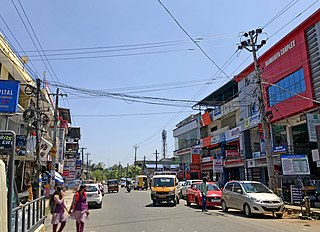
Alathur is a town, taluk and gram panchayat in Palakkad District, Kerala, India. It is the administrative headquarters of the Alathur Taluk and is situated about 24 km from the district headquarters Palakkad through National Highway 544.Gayathripuzha River ,one of the tributary of Bharathapuzha, flows through Alathur. Alathur is one among the 29 Parliamentary Constituencies in Kerala. A Mini Civil Station is also located here which provides government related services.
Arumbavur is a Town Panchayat at Veppanthattai Taluk in Perambalur district in the state of Tamil Nadu, India. The Arumbavur Town Panchayat is divided into 15 Wards for which the elections are held every 5 years. According to 2011 Census, there are total 3,452 families residing in the Arumbavur [TP]. Arumbavur is popularly renowned for Wooden Carvings (Handmade) worldwide. The 500 years old Arumbavur Wooden Carving artisans have their origin traced from Madurai. The Artisans' unique specialities is to hand carve the Wooden Statues, Natural figures, House Main Doors, Pooja Doors, Pooja Mandapas, Wall Panels, Pillars, Wall Brackets, Temple Doors, Temple Cars(Thaer), Ratham, Vaaganam, Church Wall Panels etc., which are manufactured and exported to various parts of the World. The Arumbavur wooden carvings has been granted Geographical Indication tag for its distinctiveness and quality.
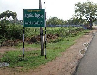
Karambakkudi is a panchayat town as well as Taluk in Pudukkottai district in the Indian state of Tamil Nadu. Karambakkudi is located about 40 km from Thanjavur and 40 km from Pudukkottai. This town is located on the border of the Thanjavur and Pudukkottai district in Tamil Nadu. The opinion of the people of this area is that this area should become an assembly constituency very soon, Here all higher secondary schools and Art's college is there.This area is covered by Delta Region.
Karumathampatti is a Municipality in the Coimbatore district in the state of Tamil Nadu, India. It is one of the prominent developing suburb in Coimbatore metropolitan area, about 25 km away from the city centre. It is situated in between NH544 which connects the city of Coimbatore with Salem – Erode – Tirupur and also in between the State Highway 165 connects Annur – Kamanaikenpalayam. Nearby places are Somanur-3 km, Avinashi-10 km, Tirupur-20 km, Sulur-15 km, Annur-16 km. Coimbatore -27,Mettupalayam-38,Palladam-19. Karumathampatti lies near the junction of two major roads, NH544(Coimbatore – Salem) and Karumathampatti – Annur road.

Lalgudi is a Municipality in Tiruchirapalli district in the Indian state of Tamil Nadu. The town of Lalgudi heads the Lalgudi taluk, Lalgudi division, Lalgudi Educational District, Lalgudi DSP and Lalgudi Constituency.
Marakkanam is a coastal panchayat town & Taluk in Viluppuram district in the Indian state of Tamil Nadu. It is well connected to the state capital Chennai and the nearby union territory of Puducherry by the East Coast Road. To the west, Marakkanam is connected to the town of Tindivanam by the SH-134. Marakkanam is situated on the declared National Waterways NW-4. On materialisation of National Waterways NW-4, Marakkanam will be connected to two states Andhra Pradesh (Kakinada) and Puducherry through north and south of Buckingham Canal.

Tharamangalam is a Municipality in Salem district in the Indian state of Tamil Nadu.

Theni Allinagaram is a valley town and a municipality, situated in the Indian state of Tamil Nadu at the foothills of Western Ghats. It is the headquarters of the Theni district, located at a distance of 70 km from Madurai. As of 2011, the town had a population of 94,453. The metro area had the population of 202,100. It is known for the large-scale trading of garlic, cotton, cardamom, grapes, bananas, mango and chilli. It hosts the second largest weekly market in Tamil Nadu and the fourth largest in South India.
Thisayanvilai is a special grade-town panchayat. It is one of the taluks in Tirunelveli district in the Indian state of Tamil Nadu.
Vellakovil is a municipal town in Kangeyam taluk of Tirupur District, in the Indian state of Tamil Nadu. It is located on National Highway 81 between Trichy and Coimbatore. The town is spread in an area of 64.75 km2. As of 2011, the town had a population of 40,359. Kannapuram village located near to this town is famous for Kangeyam breed cattle market that happens on every year during Mariyamman temple festival in the month of April. It is an industrialized town with traditional agriculture being the occupation for most of the people. It holds lot of Power looms weaving bedsheets, floor mats and cotton materials being exported to foreign countries via exporters present in Karur.

Vijayamangalam is a census town in Erode district in the Indian state of Tamil Nadu. It is located on National Highway 47 (NH-47) between Perundurai and Perumanallur.

Perumathur is a village in India. It is located in the Kunnam taluk of the Perambalur district in the state of Tamil Nadu, approximately 233 kilometres (145 mi) from the state capital of Chennai. For administrative purposes, Perumathur is divided into three sub-villages: Milaganatham, Nallur, and Perumathur Kudikadu.

Kovilambakkam is a southern suburb of Chennai, India. It is a village panchayat located in Tambaram taluk, Chengalpattu district in the state of Tamil Nadu, about 26 km from Chennai city center and 12 km from Tambaram. The neighbourhood spans the areas of Sunnambu Kolathur, Chinna Kovilambakkam and Periya Kovilambakkam.
Mavilangai/Mavalingai is a small village in Alathur Taluk, Perambalur District, Tamil Nadu state. It is located 23 km distance from its District main city Perambalur, and 256 km distance from its State Main City Chennai.
Siruvachur is a small village located in the Perambalur district of Tamil Nadu, India.
Elanthankuzhi is a Local Panchayat in Alathur Taluk, Perambalur District, Tamil Nadu state, India. The town is located 17 km from the Taluk administrative office, and 24 km from the district headquarters. The nearest city is Ariyalur (6 km).

