Paddy Island

Last updated

Paddy Island was an island in the Burnett River, northeast of the city of Bundaberg in Queensland, Australia. [1] It holds historical significance and has been a site of various events over the years. Originally an island in the Burnett River, Paddy Island has seen frontier conflicts involving squatters and station hands from surrounding properties, resulting in significant confrontations with Aboriginal communities in the area. [2]

Contents

Etymology

Fragment from Survey Plan W37.55 of the Burnett River and Eight Portions of Land Therein, Applied for Under the "Sugar and Coffee Regulations" County of Cook; 29 September 1868. Paddy Island 1868.jpg
Fragment from Survey Plan W37.55 of the Burnett River and Eight Portions of Land Therein, Applied for Under the "Sugar and Coffee Regulations" County of Cook; 29 September 1868.

On a survey plan of the Burnett River transmitted to the Queensland Surveyor General on Tuesday, 29 September 1868, the island was referenced as Coodes Island by the District Surveyor John Charlton Thompson (1827–1878).[ citation needed ]

The Blaxland Tragedy

At Tirroan (later Gin Gin) Station [3] on Monday, 4 June 1849, two young brothers, John and Peter Pegg, were out shepherding sheep when they were speared to death by local Taribelang clansmen. [3]

Gregory Blaxland Jr, the seventh and youngest son of the pioneer, farmer and explorer Gregory Blaxland (17 June 1778 – 1 January 1853), "organized a punitive party to deal with the savages", [3] which culminated in a bloody skirmish at the site of Gibson and Howes' sugar plantation at 'the Cedars', south of Bundaberg.

"The blacks were shown no mercy, but (they) .. put up a mighty fight against the firearms of the whites, they of course having no better weapons than spears." [3]

Blaxland Jr was "regarded (by the Taribelang clansmen) as their chief enemy as all actions against the blacks was directed by him." When the opportunity for retaliation presented itself, Gregory Blaxland Jr. was ambushed, abducted, and violently clubbed to death at his pastoral station in early August 1850. [3]

A retaliatory party "was organized among all (the) settlers and their employees, and they set out on their mission of revenge." [3] Guided by a 'friendly gin', the "fugitive blacks were tracked down the Burnett River, where they had foregathered at a place now called (Waterview Station) Paddy's Island, not far from the mouth of the river." [3]

Following these events, it is estimated that the death toll numbered in the hundreds. [3] Many were slaughtered whilst trying to cross from the west bank of the Burnett River to Paddy Island. [4]

Today, the custodianship of Paddy's Island is a point of contention between neighbouring tribes and a number of traditional owners. [5]

Related Research Articles

<span class="mw-page-title-main">Bundaberg</span> City in Queensland, Australia

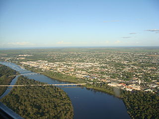
Bundaberg is a city in the Bundaberg Region, Wide Bay, Queensland, Australia, and is the tenth largest city in the state. It is a major centre of the Wide Bay–Burnett geographical region. The Bundaberg central business district is situated along the southern bank of the Burnett River, about 20 km (12 mi) from its mouth at Burnett Heads, and flows into the Coral Sea. The city is sited on a rich coastal plain, supporting one of the nation's most productive agricultural regions. The area of Bundaberg is the home of the Taribelang-Bunda, Goreng Goreng, Gurang, and Bailai peoples. Popular nicknames for Bundaberg include "Bundy", "Rum City", and "The 'Berg". The demonym of Bundaberg is Bundabergian. In the 2021 census, Bundaberg's urban area has a population of 73,747 people.

<span class="mw-page-title-main">Kabi Kabi people</span> Aboriginal Australian people of south-east Queensland

The Kabi Kabi people, also spelt Gubbi Gubbi, Gabi Gabi, and other variants, are an Aboriginal Australian people native to South Eastern Queensland. During the Australian frontier wars of the 19th century, there were several mass killings of Kabi Kabi people by settlers. They are now classified as one of several Murri language groups in Queensland. A 2024 determination granted non-exclusive native title rights over an 365,345-hectare (902,790-acre) area of land and waters on the Sunshine Coast.

<span class="mw-page-title-main">Gin Gin, Queensland</span> Town in Queensland, Australia

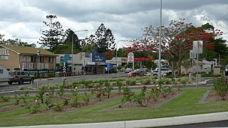
Gin Gin is a rural town and locality in the Bundaberg Region, Queensland, Australia. In the 2021 census, the locality of Gin Gin had a population of 1,139 people.

<span class="mw-page-title-main">William Forster (Australian politician)</span> Australian politician

William Forster was a pastoral squatter, colonial British politician, Premier of New South Wales from 27 October 1859 to 9 March 1860, and poet.

<span class="mw-page-title-main">Burnett Heads, Queensland</span> Town in Queensland, Australia

Burnett Heads is a coastal town and locality in the Bundaberg Region, Queensland, Australia. In the 2021 census, the locality of Burnett Heads had a population of 2,908 people.

<span class="mw-page-title-main">Wallaville</span> Town in Queensland, Australia

Wallaville is a rural town and locality in the Bundaberg Region, Queensland, Australia. It is 372 kilometres (231 mi) north of the state capital, Brisbane and 43 kilometres (27 mi) south west of the regional centre of Bundaberg. In the 2021 census, the locality of Wallaville had a population of 363 people.

<span class="mw-page-title-main">William Henry Walsh</span> Australian politician

William Henry Walsh J.P. was an Australian pioneer pastoralist or squatter and politician in early Queensland. He was a Member of the New South Wales Legislative Assembly 1859-1859, Member of the Queensland Legislative Assembly 1865–1878, and a Member of the Queensland Legislative Council 1879–1888. He was the Queensland Minister of the Crown 1870–1873, Speaker in the Queensland Legislative Assembly from 6 January 1874 to 20 July 1876.

<span class="mw-page-title-main">Mount Perry railway line</span> Railway line in Australia

The Mount Perry Branch Railway is a closed railway line in Central Queensland, Australia. In 1869 copper was discovered at Mount Perry and the township grew rapidly. A railway to the coast was essential to provide cheap transport and make the mining of low percentage ore viable. Maryborough and Bundaberg vied for the opportunity to be the terminus and the latter city was successful.

<span class="mw-page-title-main">Wide Bay–Burnett</span> Region in Queensland, Australia

Wide Bay–Burnett is a region of the Australian state of Queensland, located between 170–400 km (110–250 mi) north of the state capital, Brisbane. The area's population growth has exceeded the state average over the past 20 years, and it is forecast to grow to more than 430,000 by 2031. It is the subject of the Draft Wide Bay–Burnett Regional Plan, which aims to facilitate this growth while protecting over 90% of the region from urban development.

<span class="mw-page-title-main">1936 Bundaberg distillery fire</span> Fire in Queensland, Australia

The 1936 Bundaberg distillery fire was a disaster in Bundaberg, Queensland, Australia.

<span class="mw-page-title-main">South Kolan</span> Town in Queensland, Australia

South Kolan is a rural locality in the Bundaberg Region, Queensland, Australia. In the 2021 census, the locality of South Kolan had a population of 1,258 people.

<span class="mw-page-title-main">Oakwood, Queensland</span> Suburb of Bundaberg Region, Queensland, Australia

Oakwood is a rural locality in the Bundaberg Region, Queensland, Australia. In the 2021 census, Oakwood had a population of 364 people.

Sharon is a rural locality in the Bundaberg Region, Queensland, Australia. In the 2021 census, Sharon had a population of 1,209 people.

<span class="mw-page-title-main">Rubyanna, Queensland</span> Suburb of Bundaberg, Queensland, Australia

Rubyanna is a rural locality in the Bundaberg Region, Queensland, Australia. In the 2021 census, Rubyanna had a population of 257 people.

Bungadoo is a rural locality in the Bundaberg Region, Queensland, Australia. The area was formerly known as Albionville. In the 2021 census, Bungadoo had a population of 342 people.

Morganville is a rural locality in the Bundaberg Region, Queensland, Australia.

Monduran is a rural locality in the Bundaberg Region, Queensland, Australia. In the 2021 census, Monduran had a population of 84 people.

Duingal is a locality in the Bundaberg Region, Queensland, Australia. In the 2021 census, Duingal had a population of 70 people.

Bundaberg–Gin Gin Road is a state-controlled district road in the Bundaberg region of Queensland, Australia. It runs from Bundaberg–Bargara Road in Bundaberg Central to the Bruce Highway in Gin Gin, a distance of 48.4 kilometres (30.1 mi). It is signed as State Route 3.

References

  1. "Paddy Island – island in the Bundaberg Region (feature absent) (entry 25773)". Queensland Place Names. Queensland Government . Retrieved 11 March 2024.
  2. jane. "Some Known Frontier Conflicts in Queensland". Australian Frontier Conflicts. Retrieved 9 July 2024.
  3. 1 2 3 4 5 6 7 8 EARLY GIN GIN and THE BLAXLAND TRAGEDY Archived 19 March 2012 at the Wayback Machine . library.uq.edu.au. (Read by ARTHUR LAURIE, a Vice-President of the Historical Society of Queensland at the meeting of the Society on 27 November 1952)
  4. Contributed (8 May 2014). "The ritual of remembering". news.griffith.edu.au. Archived from the original on 14 January 2024. Retrieved 14 September 2023.
  5. Mike Derry (31 July 2010). "Island war as clan clashes | Bundaberg News | Local News in Bundaberg | Bundaberg News Mail". News-mail.com.au. Retrieved 27 June 2011.

24°49′43″S152°22′02″E / 24.82861°S 152.36722°E / -24.82861; 152.36722 (Paddy Island)