Seismic magnitude scales are used to describe the overall strength or "size" of an earthquake. These are distinguished from seismic intensity scales that categorize the intensity or severity of ground shaking (quaking) caused by an earthquake at a given location. Magnitudes are usually determined from measurements of an earthquake's seismic waves as recorded on a seismogram. Magnitude scales vary based on what aspect of the seismic waves are measured and how they are measured. Different magnitude scales are necessary because of differences in earthquakes, the information available, and the purposes for which the magnitudes are used.

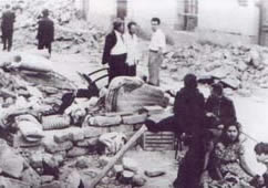
The 1944 San Juan earthquake took place in the province of San Juan, in the center-west area of Argentina, a region highly prone to seismic events. This moderate to strong earthquake destroyed a large part of San Juan, the provincial capital, and killed 10,000 of its inhabitants, 10% of its population at the time. One third of the province population became homeless. It is acknowledged as the worst natural disaster in Argentine history.
The 1861 Mendoza earthquake occurred in the province of Mendoza, Argentina on 20 March at 11:30 PM. It had an estimated magnitude of 7.2 on the scale and an intensity of IX–X on the Mercalli scale. Its hypocenter was located at an estimated depth of 30 kilometres (19 mi).
The 1948 Salta earthquake took place in the Argentinian province of Salta on 25 August at The shock was 7.0 on the moment magnitude scale and had a maximum Mercalli Intensity of IX (Violent). Property damage and casualties occurred in several towns in the east and southeast of Salta, and also in northern Tucumán and Jujuy, affecting the capitals of both. It was the last major earthquake recorded in the Argentine Northwest until the 2010 Salta earthquake.
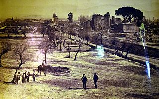
The 1894 San Juan earthquake took place in the province of San Juan, Argentina, on 27 October 1894, at about 07:30 PM. It was the most powerful earthquake recorded in Argentina, with magnitude 7.5 on the surface wave magnitude scale. Its epicenter was located to the northwest of San Juan, approximately at 29°48′S69°00′W, and at a depth of 30 km.
The 1863 Jujuy earthquake took place in the province of Jujuy, Argentina on 15 January at about 11:00 (UTC-3). It had an estimated magnitude of 6.4 and its epicenter was at 23°36′S65°00′W, at a depth of about 50 kilometres (31 mi).
The Richter scale, also called the Richter magnitude scale, Richter's magnitude scale, and the Gutenberg–Richter scale, is a measure of the strength of earthquakes, developed by Charles Francis Richter in collaboration with Beno Gutenberg, and presented in Richter's landmark 1935 paper, where he called it the "magnitude scale". This was later revised and renamed the local magnitude scale, denoted as ML or ML .
Averías is a municipality and village in the General Taboada department, province of Santiago del Estero Province in Argentina. It is located approximately 229 km from the provincial capital city of Santiago del Estero.
San Carlos is a head village of the department of San Carlos, Province of Salta, Argentina. San Carlos is a historic village in Calchaquíes Valleys located at the National Route 40, 27 km from Cafayate.
The 2011 Guerrero earthquake struck with a moment magnitude of 5.7 in southern Mexico at on 5 May. It was positioned west of Ometepec, Guerrero, with a focal depth of 24 km (14.9 mi), and was lightly felt in many adjacent areas.

The 2010 Pichilemu earthquakes, also known as the Libertador O'Higgins earthquakes, were a pair of intraplate earthquakes measuring 6.9 and 7.0 that struck Chile's O'Higgins Region on 11 March 2010 about 16 minutes apart. The earthquakes were centred 15 kilometres (9.3 mi) northwest of the city of Pichilemu.

Rinconada is a department in the province of Jujuy in the Argentina. According to INDEC its population in 2010 was 2,489 inhabitants. Its main town is Rinconada. The town of Mina Pirquitas represents the highest point in Argentina, standing at 4,271 m above sea level.
The 1844 Salta earthquake took place in the Province of Salta, in the Republic of Argentina, on 18 October at 23:00 UTC. It had an estimated magnitude of 6.5 . The earthquake had an estimated hypocentral depth of 30 km.
The 1927 Mendoza earthquake took place in Mendoza Province, in the Republic of Argentina, on 14 April at 06:23:28 UTC. It registered a magnitude of 7.1 on the Richter magnitude scale. The earthquake was located at a depth of 110 kilometres (68 mi).
The department of Tafí Viejo is a department of the province of Tucumán (Argentina), created in 1907 by the reform of the provincial constitution, which divided the old department Tafí. Its head is the homonymous city. Bordered on the north by the department Trancas, east to Burruyacú and Cruz Alta, south of Capital, Yerba Buena and Lules, and west to Tafí del Valle.
The 2010 Aguas Buenas earthquake, also referred to as the 2010 Christmas Eve earthquake, occurred on December 24 at 7:43 p.m. local time in Aguas Buenas, Puerto Rico. It measured 5.1 on the moment magnitude scale and had a maximum Mercalli intensity of VI (Strong). The event was the largest in Puerto Rico since May 16th of the same year, and the largest to impact the San Juan metropolitan area since 1975. The earthquake was felt throughout the island of Puerto Rico, the island municipalities of Vieques and Culebra, the American and British Virgin Islands, and even in the Dominican Republic across the Mona Passage.
Villa Ibáñez is a locality located in the south-central province of San Juan, west of the agricultural oasis of Ullúm, northwest of the city of San Juan, Argentina. It is the seat of the Ullúm Department. Today, the town is the nucleus of an important wine, fruit and olive region par excellence of the aforementioned province.

The Cabildo of Jujuy is a cabildo founded on 19 April 1593 at the Argentina province of Jujuy. It was where Manuel Belgrano showed the National Argentine Flag, on 25 May 1812. It collapsed by the 1863 Jujuy earthquake, and started being reconstructed in 1864 and finally finished three years later in 1867. On 14 July 1941, it was declared Monumento Histórico Nacional.
