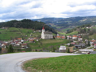
Šmartno ob Paki is a settlement and a small municipality in the lower Paka Valley in northern Slovenia. The area was part of the traditional region of Styria. It is now included in the Savinja Statistical Region.

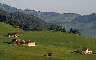
Paka pri Velenju is a settlement in the Municipality of Velenje in northern Slovenia. The area was traditionally part of Styria. The entire municipality is now included in the Savinja Statistical Region.
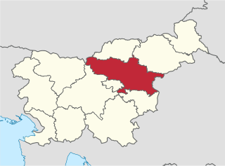
The Savinja Statistical Region is a statistical region in Slovenia. The largest town in the region is Celje. It is named after the Savinja River. The region is very diverse in natural geography; it mainly comprises the wooded mountainous terrain attractive to tourists, the fertile Lower Savinja Valley with good conditions for growing hops, the Kozje Hills, and the Velenje Basin with lignite deposits, used for electricity production. In 2013 the region invested more than EUR 127 million in environmental protection. In 2013, the region accounted for 14% of enterprises created and 8% of enterprises shut down. The region has good natural conditions for agriculture. In 2013 this region had more than 11,000 farms, which is 15% of all farms in Slovenia, ranking the region right behind the Drava Statistical Region. In agricultural area utilised and livestock, the region was also in second place. The region is a well-known and popular tourist destination. In 2012, tourist arrivals and overnight stays in the region represented 11.1% of all tourist arrivals in Slovenia and 15.0% of all overnight stays. On average, tourists spent four nights there.
Dolnja Paka is a small settlement west of the town of Črnomelj in the White Carniola area of southeastern Slovenia. The area is part of the traditional region of Lower Carniola and is now included in the Southeast Slovenia Statistical Region.
Gornja Paka is a settlement north of the town of Črnomelj in the White Carniola area of southeastern Slovenia. The area is part of the traditional region of Lower Carniola and is now included in the Southeast Slovenia Statistical Region.
Paka pri Predgradu is a small settlement northwest of Stari Trg ob Kolpi in southern Slovenia. It belongs to the Municipality of Kočevje. The area is part of the traditional region of Lower Carniola and is now included in the Southeast Slovenia Statistical Region.
Zlateče is a settlement in the Municipality of Vojnik in eastern Slovenia. It lies north of Nova Cerkev, on the left side of the road to Vitanje. The area was traditionally part of the Styria region. It is now included with the rest of the municipality in the Savinja Statistical Region.
Brezen is a dispersed settlement in the Municipality of Vitanje in northeastern Slovenia. The area was traditionally part of the Styria region. It is now included with the rest of the municipality in the Savinja Statistical Region.
Hudinja is a dispersed settlement in the Municipality of Vitanje in northeastern Slovenia. It lies in the hills north of Vitanje at the source of the Hudinja River. The area was traditionally part of the Styria region. It is now included with the rest of the municipality in the Savinja Statistical Region.
Ljubnica is a dispersed settlement in the Municipality of Vitanje in northeastern Slovenia. The area is part of the traditional region of Styria and is now included with the rest of the municipality in the Savinja Statistical Region.
Spodnji Dolič is a dispersed settlement in the hills northwest of Vitanje in northeastern Slovenia. The area was traditionally part of the Styria region. It is now included with the rest of the Municipality of Vitanje in the Savinja Statistical Region.
Stenica is a dispersed settlement in the Municipality of Vitanje in northeastern Slovenia. It lies in the hills south and east of Vitanje. Traditionally it was part of the Styria region and is now included in the Savinja Statistical Region.
Vitanjsko Skomarje is a dispersed settlement in the Municipality of Vitanje in northeastern Slovenia. The area was traditionally part of the Styria region. It is now included with the rest of the municipality in the Savinja Statistical Region.
Lipa is a small settlement in the Municipality of Zreče in northeastern Slovenia. It lies on the main road leading west from Zreče towards Vitanje. The area was traditionally part of the Styria region. It is now included with the rest of the municipality in the Savinja Statistical Region.

Skomarje is a settlement in the Pohorje Hills northwest of Zreče in northeastern Slovenia. The area was traditionally part of Styria. It is now included with the rest of the Municipality of Zreče in the Savinja Statistical Region.
Paka is a dispersed settlement in the Municipality of Mislinja in northern Slovenia. It lies in the southern part of the Pohorje Hills with the main part of the settlement extending into the neighbouring Municipality of Vitanje. The area was traditionally part of Carinthia. It is now included in the Carinthia Statistical Region.

Srednji Dolič is a settlement in the Municipality of Mislinja in northern Slovenia. It lies at the upper course of the Paka River, in the hills either side of the regional road from Mislinja to Vitanje. The area was traditionally part of Carinthia. It is now included in the Carinthia Statistical Region.

Paka is a small settlement in the Municipality of Dobrepolje in Slovenia. The area is part of the historical region of Lower Carniola. The municipality is now included in the Central Slovenia Statistical Region.