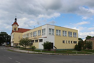
Pavlíkov is a market town in the Central Bohemian Region of the Czech Republic. It has around 1,010 inhabitants.

Jeníkov is a village in the Pardubice Region of the Czech Republic. It has around 480 inhabitants.

The Calanque de Sormiou is the biggest calanque of the Calanques National Park, France. Located in the 9th arrondissement of Marseille, it is famous for its climbing spots. Access by car is restricted in the summer due to the risk of forest fires.

Hontianske Trsťany is a village and municipality in the Levice District in the Nitra Region of Slovakia.
Reg District is situated in the southern part of Kandahar Province, Afghanistan. It borders Helmand Province to the west, Panjwai and Daman districts to the north, Shorabak District to the east and Pakistan to the south. The population is 7,900 (2006). The district center is the village Reg Alaqadari, located in the most southeastern part of the district - a few miles from the international border with Pakistan.

Łosiny is a village in the administrative district of Gmina Tuchola, within Tuchola County, Kuyavian-Pomeranian Voivodeship, in north-central Poland. It lies approximately 17 kilometres (11 mi) north of Tuchola and 70 km (43 mi) north of Bydgoszcz.
Dołhołęka is a village in the administrative district of Gmina Międzyrzec Podlaski, within Biała Podlaska County, Lublin Voivodeship, in eastern Poland.
Roztoka is a village in the administrative district of Gmina Żmudź, within Chełm County, Lublin Voivodeship, in eastern Poland.
Brzeziny is a village in the administrative district of Gmina Żytno, within Radomsko County, Łódź Voivodeship, in central Poland.
Wolica-Kolonia is a village in the administrative district of Gmina Karczmiska, within Opole Lubelskie County, Lublin Voivodeship, in eastern Poland. It lies approximately 4 kilometres (2 mi) south-east of Karczmiska, 8 km (5 mi) north-east of Opole Lubelskie, and 39 km (24 mi) west of the regional capital Lublin.
Dwernik is a village in the administrative district of Gmina Lutowiska, within Bieszczady County, Subcarpathian Voivodeship, in south-eastern Poland, close to the border with Ukraine. It lies approximately 8 kilometres (5 mi) south-west of Lutowiska, 26 km (16 mi) south of Ustrzyki Dolne, and 102 km (63 mi) south-east of the regional capital Rzeszów.
Szabelnia is a village in the administrative district of Gmina Końskie, within Końskie County, Świętokrzyskie Voivodeship, in south-central Poland. It lies approximately 8 kilometres (5 mi) west of Końskie and 43 km (27 mi) north-west of the regional capital Kielce.
Gąsocin is a village in the administrative district of Gmina Sońsk, within Ciechanów County, Masovian Voivodeship, in east-central Poland. It lies approximately 5 kilometres (3 mi) south of Sońsk, 15 km (9 mi) south of Ciechanów, and 62 km (39 mi) north of Warsaw.
Ignacówka is a village in the administrative district of Gmina Sochaczew, within Sochaczew County, Masovian Voivodeship, in east-central Poland. It lies approximately 4 kilometres (2 mi) south-east of Sochaczew and 49 km (30 mi) west of Warsaw.

Peraküla is a village in Lääne-Nigula Parish, Lääne County, in western Estonia.
Lõpi is a village in Saaremaa Parish, Saare County in western Estonia.

Udrežnje is a village in the municipality of Nevesinje, Republika Srpska, Bosnia and Herzegovina.

Oreovica is a village in the municipality of Žabari, Serbia. According to the 2002 census, the village has a population of 862 people.
Kani is a town in Sagaing Region, Myanmar. It is situated on the west bank of Chindwin river. It is 104 miles away from Pakokku. Its township boundary is touched with ones of Mingin Township in the north and Budalin Township in the east. There are Pone Taung Hills in the west of the township. There are also many streams in the township. It has an area of 1736 sq-miles. At the age of Myanmar dynasties, its area was wider ago. There is Shwe Myin Phyu Hill at the north. That hill was a city ago and so the remains of moats and castle area wall. Myin Phyu Shin Divinity which is famous in Myanmar now is Kani Nawyahtār who was the city governor of Kani when King Ah Nawyahtār governed the country. The mayor of Kani was the General of Shield army, who was father of Dye Khin Khin, at the age of King Si Paw. According to census at 1951, population of the town was just 2500 people.
Zivovo is a former village in Municipality of Prilep, Republic of North Macedonia.


