
The Royal Borough of Kensington and Chelsea is an Inner London borough with royal status. It is the smallest borough in London and the second smallest district in England; it is one of the most densely populated administrative regions in the United Kingdom. It includes affluent areas such as Notting Hill, Kensington, South Kensington, Chelsea, and Knightsbridge.

The Mall is a ceremonial route and roadway in the City of Westminster, central London, that travels 1 kilometre (0.62 mi) between Buckingham Palace at its western end and Trafalgar Square via Admiralty Arch to the east. Along the north side of The Mall is green space and St. James's Palace with other official buildings, and to the south is St James's Park. Near the east end at Trafalgar Square and Whitehall it is met by Horse Guards Road and Spring Gardens, near the west end at the Victoria Memorial it is met by the Constitution Hill roadway and the Spur Road to the street of Buckingham Gate. It is closed to traffic on Saturdays, Sundays, public holidays and on ceremonial occasions.

Bushy Park in the London Borough of Richmond upon Thames is the second largest of London's Royal Parks, at 445 hectares in area, after Richmond Park. The park, most of which is open to the public, is immediately north of Hampton Court Palace and Hampton Court Park and is a few minutes' walk from the west side of Kingston Bridge. It is surrounded by Teddington, Hampton, Hampton Hill and Hampton Wick and is mainly within the post towns of Hampton and Teddington, those of East Molesey and Kingston upon Thames taking the remainder.

Llantwit Major is a town and community in Wales on the Bristol Channel coast. It is one of four towns in the Vale of Glamorgan, with the third largest population after Barry and Penarth, and ahead of Cowbridge. It is 4+1⁄2 miles (7.2 km) from Cowbridge, 9 miles (14 km) from Bridgend, 10 miles (16 km) from Barry, and 15 miles (24 km) from Cardiff. It had a population of 9,530 in 2021.

Kensington Road is a section of road in the Royal Borough of Kensington and Chelsea and the City of Westminster, London, forming part of the A315 road.

Ossington Street is a quiet one-way street in London, W2, leading from Moscow Road at its north end to the Bayswater Road / Notting Hill Gate at its south end.

Bayswater Road is the main road running along the northern edge of Hyde Park in London. Originally part of the A40 road, it is now designated part of the A402 road.

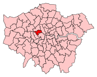
Cities of London and Westminster is a constituency returning a single Member of Parliament (MP) to the House of Commons in the United Kingdom Parliament. As with all constituencies, the election is decided using the first past the post system of election. Until the 2024 general election, where the constituency elected a Labour Co-op MP, the constituency had always elected the candidate nominated by the Conservative Party.

Hampton Court Park, also known as Home Park, is a walled royal park managed by the Historic Royal Palaces. The park lies between the gardens of Hampton Court Palace and Kingston upon Thames and Surbiton in south west London, England, mostly within the post town of East Molesey, but with its eastern extremity within the post town of Kingston. In 2014, part of the park was designated a biological Site of Special Scientific Interest. It takes up most of the final (lowest) meander of the non-tidal reaches of the River Thames and is mainly divided between a golf course, meadows interspersed with trees used for deer, seasonal horse grazing and wildlife. A corner of the park is used annually for the Hampton Court Flower Show and the part nearest to the palace has the Long Water — an early set of hydro-engineered ponds or lakes, fed by water from the distant River Colne, as are the bodies of water in the neighbouring park, Bushy Park.

Richmond Green is a recreation area near the centre of Richmond, a town of about 20,000 inhabitants situated in south-west London. Owned by the Crown Estate, it is leased to the London Borough of Richmond upon Thames. The Green, which has been described as "one of the most beautiful urban greens surviving anywhere in England", is roughly square in shape and its open grassland, framed with broadleaf trees, extends to roughly twelve acres. On the north-east side there is also a smaller open space called Little Green. Richmond Green and Little Green are overlooked by a mixture of period townhouses, historic buildings and municipal and commercial establishments including the Richmond Lending Library and Richmond Theatre.
Westminster North was a constituency in Greater London represented in the House of Commons of the UK Parliament. It existed for the periods 1983–1997 and 2010–2024.

Kensington is a former constituency in Greater London which first existed between 1974 and 1997 and was recreated in 2010. It was replaced by the Kensington and Bayswater constituency, first contested at the 2024 general election.

Hyde Park Gate is a street in Central London, England, which applies to two parallel roads in Kensington on the southern boundary of Kensington Gardens. These two roads run south, perpendicular to Kensington Road, but the name Hyde Park Gate also applies to the houses on the south side of that road between Queen's Gate and De Vere Gardens.

Coade stone or Lithodipyra or Lithodipra is stoneware that was often described as an artificial stone in the late 18th and early 19th centuries. It was used for moulding neoclassical statues, architectural decorations and garden ornaments of the highest quality that remain virtually weatherproof today.

Queen's Gate is a street in South Kensington, London, England. It runs south from Kensington Gardens' Queen's Gate to Old Brompton Road, intersecting Cromwell Road.
The Guards Club, established in 1810, was a London Gentlemen's club for officers of the Guards Division, originally defined by the club as being the Coldstream Guards, Grenadier Guards or Scots Guards, traditionally the most socially elite section of the British Army. Officers of the Welsh and Irish Guards were not able to join until the second half of the 20th century. Its clubhouse at 70 Pall Mall was the first to be built on that street, which later became noted for its high concentration of clubs; earlier clubs had been focused on the adjoining St James's Street.

St George Hanover Square was a civil parish in the metropolitan area of London, England. The creation of the parish accompanied the building of the Church of St George's, Hanover Square, constructed by the Commission for Building Fifty New Churches to meet the demands of the growing population. The parish was formed in 1724 from part of the ancient parish of St Martin in the Fields in the Liberty of Westminster and county of Middlesex. It included some of the most fashionable areas of the West End, including Belgravia and Mayfair. Civil parish administration, known as a select vestry, was dominated by members of the British nobility until the parish adopted the Vestries Act 1831. The vestry was reformed again in 1855 by the Metropolis Management Act. In 1889 the parish became part of the County of London and the vestry was abolished in 1900, replaced by Westminster City Council. The parish continued to have nominal existence until 1922. As created, it was a parish for both church and civil purposes, but the boundaries of the ecclesiastical parish were adjusted in 1830, 1835 and 1865.

Campden Hill is a hill in Kensington, West London, bounded by Holland Park Avenue on the north, Kensington High Street on the south, Kensington Palace Gardens on the east and Abbotsbury Road on the west. The name derives from the former Campden House, built by Baptist Hicks, 1st Viscount Campden whose country seat was Campden House in the Gloucestershire town of Chipping Campden.

King Street, Hammersmith is the main shopping street in Hammersmith, London. It runs west–east, and forms part of the A315, and is the eastern continuation of Chiswick High Road, where it meets Goldhawk Road, close to Stamford Brook tube station. At the eastern end it meets Hammersmith Broadway and continues east as Hammersmith Road where it forms a crossroads with the A219, the Shepherd's Bush Road running northwards, and the Fulham Palace Road running south.

Chesterfield Street is a "virtually intact" Georgian street in London's Mayfair district. Several of the buildings are Grade II listed on the National Heritage List for England.
