Related Research Articles
Camps are set up by the United Nations Relief and Works Agency (UNRWA) in Jordan, Lebanon, Syria, the West Bank and the Gaza Strip to accommodate Palestinian refugees registered with UNRWA, who fled or were expelled during the 1948 Palestinian expulsion and flight after the 1948 Arab–Israeli War or in the aftermath of the Six-Day War in 1967, and their patrilineal descendants. There are 68 Palestinian refugee camps, 58 official and 10 unofficial, ten of which were established after the Six-Day War while the others were established in 1948 to 1950s.
Maghazi is a Palestinian town located in the Deir al-Balah Governorate in the central Gaza Strip. It was established as a Palestinian refugee camp in 1949. According to the Palestinian Central Bureau of Statistics, the town had a population of 18,157 in 2017 and the Maghazi municipality had a population of 9,670. The town is built on 559 dunums (0.6 km²).

The 74th (Yeomanry) Division was a Territorial Force infantry division formed in Palestine in early 1917 from three dismounted yeomanry brigades. It served in the Sinai and Palestine Campaign of the First World War, mostly as part of XX Corps. In May 1918 it was sent to the Western Front where it remained until the end of the war.

Deir al-Balah or Deir al Balah is a Palestinian city in the central Gaza Strip and the administrative capital of the Deir el-Balah Governorate of the State of Palestine. It is located over 14 kilometers (8.7 mi) south of Gaza City. The city had a population of 75,132 in 2017. The city is known for its date palms, after which it is named.
Education in the State of Palestine refers to the educational system in the Gaza Strip and the West Bank, which is administered by the Palestinian Ministry of Education and Higher Education. Enrollment rates amongst Palestinians are relatively high by regional and global standards. According to a youth survey in 2003, 60% between the ages 10–24 indicated that education was their first priority. Youth literacy rate is 98.2%, while the national literacy rate is 91.1%. Enrollment ratios for higher education were 45% in 2022. In 2016 Hanan Al Hroub was awarded the Varkey Foundation Global Teacher Prize for her work in teaching children how to cope with violence.

The 16 Governorates of the Palestinian National Authority are divided into 16 electoral regions.
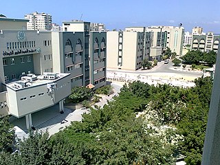
The Islamic University of Gaza, also known as IUG and IU Gaza, is an independent Palestinian university established in 1978 in Gaza City. It was the first higher education institution to be established in Gaza Strip. The university has eleven faculties capable of awarding BA, BSc, MA, MSc, MD, PhD, diplomas and higher diplomas, in addition to twenty research centers and institutes and the affiliated Turkish-Palestinian Friendship Hospital.
Deir al-Balah Camp is a Palestinian refugee camp in the Deir al-Balah Governorate of the southern Gaza Strip, located one kilometer northwest of the center of Deir al-Balah city, of which it practically forms part. The camp consists of concrete buildings and has eight schools, sewers, and other municipal services. According to the Palestinian Central Bureau of Statistics, the camp had a population of 6,985 in 2017. It is the smallest refugee camp in the Gaza Strip. Deir al-Balah Camp is built on an area of 0.16 square kilometers. As of March 2005, the population registered with the United Nations Relief and Works Agency (UNRWA) was 19,534 persons.
Ahmad Kurd was a Palestinian politician, who served as the mayor of Deir al-Balah located in the central Gaza Strip. He was elected as mayor in 2005 as the candidate for the political party and militant group, Hamas. He also occupied the job of local sheikh in the Deir al-Balah mosque.
No. 5 Wing of the Royal Air Force was a wing of aircraft squadrons which was originally established as the Fifth Wing of the Royal Flying Corps. Currently inactive, the wing has been formed and disbanded five times over the course of its history.
The Gaza Subdistrict was one of the subdistricts of Mandatory Palestine. It was situated in the southern Mediterranean coastline of the British Mandate of Palestine. After the 1948 Arab-Israeli War, the district disintegrated, with Israel controlling the northern and eastern portions while Egypt held control of the southern and central parts – which became the Gaza Strip, under Egyptian military between 1948 and 1967, Israeli military rule between 1967 and 2005, part of the Palestinian National Authority after the Oslo Accords until 2007, and is currently ruled by the Hamas as a de facto separate entity from the Palestinian National Authority. The parts which Israel held since 1948 were merged into Israeli administrative districts, their connection with Gaza severed.
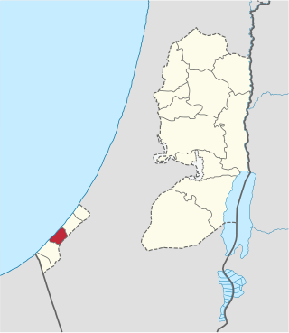
The Deir al-Balah Governorate, also referred to as Central Gaza Governorate is one of 16 Governorates of Palestine in the central Gaza Strip which is administered by Palestine aside from its border with Israel, airspace, and maritime territory. Its total land area consists of 56 sq. kilometers. According to the Palestinian Central Bureau of Statistics, in mid-year 2022 it had a population of 310,820 inhabitants distributed between eight localities.

Tell es-Sakan, lit. "Hill of Ash", is a now almost entirely destroyed tell standing some 5 km south of Gaza City in what is today the Gaza Strip, on the northern bank of Wadi Ghazzeh. It was the site of two separate Early Bronze Age urban settlements: an earlier one representing the fortified administrative center of the Egyptian colonies in southwestern Palestine from the end of the 4th millennium, and a later, local Canaanite fortified city of the third millennium. The location at the mouth of what was probably a palaeochannel of the river, allowed it to develop as an important maritime settlement with a natural harbour. Its geographical location endowed it with a position of importance at the crossroads of land-based trade routes between the Canaan region, the Old Kingdom of Egypt, and Arabia. As of 2000, the early Egyptian settlement was the oldest fortified site known to researchers in both Egypt and Palestine.
Az-Zawayda, also spelled Zawaida, is a Palestinian town in the Gaza Strip, in the Deir al-Balah Governorate of the State of Palestine. It is located about three kilometers northeast of the city of Deir al-Balah and just west of Maghazi refugee camp. According to the Palestinian Central Bureau of Statistics (PCBS) 2017 census, there were 23,841 residents.
Al-Musaddar is a Palestinian village in the central Gaza Strip, part of the Deir al-Balah Governorate east of Deir al-Balah, south of the Maghazi refugee camp and west of the border with Israel. In the 1997 census its population was 1,277. Al-Musaddar had a population of 2,587 in 2017 according to the Palestinian Central Bureau of Statistics (PCBS).
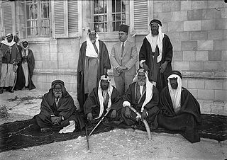
Al-Hanajira was one of the five principal Bedouin tribes inhabiting the Negev Desert prior to the 1948 Arab-Israeli War. Its territory stretched north-south between Deir al-Balah and Gaza and east to the lands of the Tarabin bedouin, straddling the Hejaz Railway line. Under the British Mandate, the territory was divided between its Gaza and Beersheba. The largest clan was Abu Middein. In the 1931 British census of Palestine, Abu Middein numbered 1,419, Nuseirat numbered 1,104, Sumeiri 772, and al-Dawahra 461, bringing the total to 3,735. By the summer of 1946 the population increased to 7,125. In 1981 the population living in the Gaza Strip was roughly 10,000.

The Commonwealth Gaza War Cemetery, often referred to as the British War Cemetery, is a cemetery administered by the Commonwealth War Graves Commission on the Salah al-Din Road in Gaza City's Tuffah district.
Tell Umm el-'Amr, also know as Tell Umm Amer, is an archaeological site located in the Nuseirat refugee camp, Deir el-Balah governorate, Gaza Strip.
References
- ↑ College profile at UNESCO website