
The Continuation War, also known as the Second Soviet-Finnish War, was a conflict fought by Finland and Nazi Germany against the Soviet Union from 1941 to 1944, as part of World War II. In Soviet historiography, the war was called the Finnish Front of the Great Patriotic War. Germany regarded its operations in the region as part of its overall war efforts on the Eastern Front and provided Finland with critical material support and military assistance, including economic aid.

Finland, officially the Republic of Finland, is a Nordic country in Northern Europe. It shares land borders with Sweden to the northwest, Norway to the north, and Russia to the east, with the Gulf of Bothnia to the west and the Gulf of Finland across Estonia to the south. Finland covers an area of 338,455 square kilometres (130,678 sq mi) with a population of 5.6 million. Helsinki is the capital and largest city, forming a larger metropolitan area with the neighbouring cities of Espoo, Kauniainen, and Vantaa. The vast majority of the population are ethnic Finns. Finnish, alongside Swedish, are the official languages. Swedish is the native language of 5.2% of the population. Finland's climate varies from humid continental in the south to the boreal in the north. The land cover is primarily a boreal forest biome, with more than 180,000 recorded lakes.

The geography of Finland is characterized by its northern position, its ubiquitous landscapes of intermingled boreal forests and lakes, and its low population density. Finland can be divided into three areas: archipelagoes and coastal lowlands, a slightly higher central lake plateau and uplands to north and northeast. Bordering the Baltic Sea, Gulf of Bothnia, and Gulf of Finland, as well as Sweden, Norway, and Russia, Finland is the northernmost country in the European Union. Most of the population and agricultural resources are concentrated in the south. Northern and eastern Finland are sparsely populated containing vast wilderness areas. Taiga forest is the dominant vegetation type.

Lake Ladoga is a freshwater lake located in the Republic of Karelia and Leningrad Oblast in northwestern Russia, in the vicinity of Saint Petersburg.

The Winter War, also known as the First Soviet-Finnish War, was a war between the Soviet Union and Finland. The war began with a Soviet invasion of Finland on 30 November 1939, three months after the outbreak of World War II, and ended three and a half months later with the Moscow Peace Treaty on 13 March 1940. Despite superior military strength, especially in tanks and aircraft, the Soviet Union suffered severe losses and initially made little headway. The League of Nations deemed the attack illegal and expelled the Soviet Union from the organisation.

Espoo is a city and municipality in the region of Uusimaa in the Republic of Finland. It is located on the northern shore of the Gulf of Finland, bordering the cities of Helsinki, Vantaa, Kirkkonummi, Vihti and Nurmijärvi while surrounding the enclaved town of Kauniainen. The city covers 528.03 square kilometres (203.9 sq mi) with a population of about 300 000 residents in 2022, making it the 2nd-most populous city in Finland. Espoo forms a major part of a substantially larger metropolitan area known as Greater Helsinki, home to over 1.5 million people in 2020.
Tampere is a city in the Pirkanmaa region, located in the western part of Finland. Tampere is the most populous inland city in the Nordic countries. It has a population of 244,029; the urban area has a population of 341,696; and the metropolitan area, also known as the Tampere sub-region, has a population of 393,941 in an area of 4,970 km2 (1,920 sq mi). Tampere is the second-largest urban area and third most-populous individual municipality in Finland, after the cities of Helsinki and Espoo, and the most populous Finnish city outside the Greater Helsinki area. Today, Tampere is one of the major urban, economic, and cultural hubs in the whole inland region.
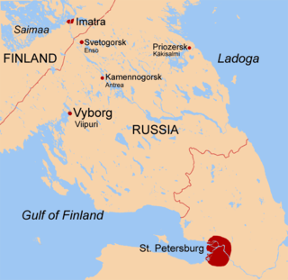
The Karelian Isthmus is the approximately 45–110-kilometre-wide (30–70 mi) stretch of land, situated between the Gulf of Finland and Lake Ladoga in northwestern Russia, to the north of the River Neva. Its northwestern boundary is a line from the Bay of Vyborg to the westernmost point of Lake Ladoga, Pekonlahti. If the Karelian Isthmus is defined as the entire territory of present-day Saint Petersburg and Leningrad Oblast to the north of the Neva and also a tiny part of the Republic of Karelia, the area of the isthmus is about 15,000 km2 (5,800 sq mi).

Lappeenranta is a city and municipality in the region of South Karelia, about 30 kilometres from the Russian border and 64 kilometres (40 mi) from the town of Vyborg (Viipuri). It is situated on the shore of the Lake Saimaa in southeastern Finland, and is one of the most significant urban centers in the whole Saimaa region, along with the towns of Imatra, Mikkeli and Savonlinna. With approximately 73,000 inhabitants Lappeenranta is the 13th largest city in Finland, after incorporating the previous municipalities of Lappee and Lauritsala in 1967, Nuijamaa in 1989, Joutseno in 2009, and Ylämaa in 2010.

Jyväskylä is a city and municipality in Finland in the western part of the Finnish Lakeland. It is located about 150 km north-east from Tampere, the third largest city in Finland; and about 270 km north from Helsinki, the capital of Finland. The Jyväskylä sub-region includes Jyväskylä, Hankasalmi, Laukaa, Petäjävesi, Toivakka, and Uurainen. Other border municipalities of Jyväskylä are Joutsa, Jämsä and Luhanka.

Lapland is the largest and northernmost region of Finland. The 21 municipalities in the region cooperate in a Regional Council. Lapland borders the region of North Ostrobothnia in the south. It also borders the Gulf of Bothnia, Norrbotten County in Sweden, Troms and Finnmark County in Norway, and Murmansk Oblast and the Republic of Karelia in Russia. Topography varies from vast mires and forests of the South to fells in the North. The Arctic circle crosses Lapland, so polar phenomena such as the midnight sun and polar night can be viewed in Lapland.

Hämeenlinna is a city and municipality of about 68,000 inhabitants in the heart of the historical province of Tavastia and the modern province of Kanta-Häme in the south of Finland. Hämeenlinna is the oldest inland city of Finland and was one of the most important Finnish cities until the 19th century. It remains an important regional center. The medieval Häme Castle is located in the city.

Saimaa is a lake located in the Finnish Lakeland area in southeastern Finland. At approximately 4,400 square kilometres (1,700 sq mi), it is the largest lake in Finland, and the fourth largest natural freshwater lake in Europe.
Nurmijärvi is the most populated rural municipality of Finland, located 37 kilometres (23 mi) north of the capital Helsinki. The neighboring municipalities of Nurmijärvi are Espoo, Vantaa, Tuusula, Hyvinkää and Vihti, and it is part of the Greater Helsinki. The population of the municipality is 44,136 inhabitants. In recent decades, it has been one of the fastest growing municipalities in the Greater Helsinki and also in whole Finland in terms of population. The close proximity to Helsinki has led to a considerable growth of the major villages such as Klaukkala, Rajamäki and Röykkä. Klaukkala is the biggest built-up area of Nurmijärvi, which nowadays is considered a dormitory town of Helsinki. The Nurmijärvi church village (Kirkonkylä) is the administrative centre of the municipality, although the clear emphasis on population growth is in Klaukkala.

The Vuoksi is a river running through the northernmost part of the Karelian Isthmus from Lake Saimaa in southeastern Finland to Lake Ladoga in northwestern Russia. The river enters Lake Ladoga in three branches, an older main northern branch at Priozersk (Käkisalmi), a smaller branch a few kilometers to the north of it, and a new southern branch entering 50 kilometers (31 mi) further southeast as Burnaya River, which has become the main stream in terms of water discharge. Since 1857, the old northern distributaries drain only the lower reaches of the Vuoksi basin and are not fed by Lake Saimaa. The northern and southern branches actually belong to two separate river systems, which at times get isolated from each other in dry seasons.
Karelia, the land of the Karelian people, is an area in Northern Europe of historical significance for Russia, Finland, and Sweden. It is currently divided between northwestern Russia and Finland.

Lappajärvi is a lake in Finland, in the municipalities of Lappajärvi, Alajärvi and Vimpeli. It is formed in a 23 km (14 mi) wide, partly eroded meteorite impact crater. The lake is part of Ähtävänjoki basin together with Lake Evijärvi that is located downstream (north) of it.

Central Finland is a region in Finland. It borders the regions of Päijät-Häme, Pirkanmaa, South Ostrobothnia, Central Ostrobothnia, North Ostrobothnia, North Savo, and South Savo. The city of Jyväskylä is the regional centre and by far the largest city in the area.
Päijät-Häme is a region in Southern Finland south of the lake Päijänne. It borders the regions of Uusimaa, Tavastia Proper (Kanta-Häme), Pirkanmaa, Central Finland, South Savo and Kymenlaakso. The biggest city in the region is Lahti.
