Related Research Articles
Sri Lanka, formerly known as Ceylon and officially the Democratic Socialist Republic of Sri Lanka, is an island country in South Asia. It lies in the Indian Ocean, southwest of the Bay of Bengal, separated from the Indian peninsula by the Gulf of Mannar and the Palk Strait. Sri Lanka shares a maritime border with the Maldives in the south-west and India in the north-west.

The Western Province is one of the nine provinces of Sri Lanka, the first level administrative division of the country. The provinces have existed since the 19th century but did not have any legal status until 1987 when the 13th Amendment to the Constitution of Sri Lanka established provincial councils. Western Province is the most densely populated province in the country and is home to the legislative capital Sri Jayawardenepura Kotte as well as to Colombo, the nation's administrative and business center.

Provinces are the first level administrative divisions of Sri Lanka. Currently, Sri Lanka is divided into 9 provinces. Each province is further divided into districts, which are further divided into divisional secretariats.
Islam is the third largest religion in Sri Lanka, with about 9.7 percent of the total population following the religion. About 1.9 million Sri Lankans adhere to Islam as per the Sri Lanka census of 2012. The majority of Muslims in Sri Lanka are concentrated in the Eastern Province of the island. Other areas containing significant Muslim minorities include the Western, Northwestern, North Central, Central and Sabaragamuwa provinces. Muslims form a large segment of the urban population of Sri Lanka and are mostly concentrated in major cities and large towns in Sri Lanka, for example Colombo. Most Sri Lankan Muslims primarily speak Tamil language, though it is not uncommon for Sri Lankan Muslims to be fluent in Sinhalese.

The Sabaragamuwa Province is one of the nine provinces of Sri Lanka, the first level administrative division of the country. The provinces have existed since the 19th century but did not have any legal status until 1987 when the 13th Amendment to the Constitution of Sri Lanka established provincial councils. The Sabaragamuwa Province contains two districts: Ratnapura and Kegalle. It is named after its former indigenous inhabitants, namely the Sabara, an indic term for hunter-gatherer tribes, a term seldom used in ancient Sri Lanka. Sabaragamuwa University is in Belihuloya.

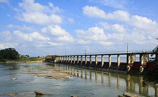
Kegalle is a large town in Sabaragamuwa Province of Sri Lanka. It is located on the Colombo–Kandy road, approximately 78 km (48 mi) from Colombo and 40 km (25 mi) from Kandy. It is the main town in the Kegalle District, which is one of two districts which comprise Sabaragamuwa Province. The town is governed by an Urban Council.
The Eastern Province is one of the nine provinces of Sri Lanka, the first level administrative division of the country. The provinces have existed since the 19th century but did not have any legal status until 1987 when the 13th Amendment to the Constitution of Sri Lanka established provincial councils. Between 1988 and 2006 the province was temporarily merged with the Northern Province to form the North Eastern Province. The capital of the province is Trincomalee. Kalmunai is the largest and most populous city of Eastern Province.
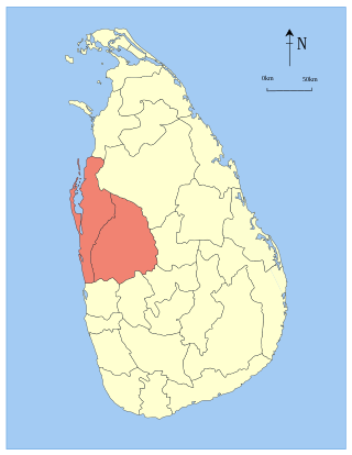
North Western Province is a province of Sri Lanka. The province consists of the districts of Kurunegala and Puttalam. Its capital is Kurunegala, which has a population of 28,571. The province is known mainly for its numerous coconut plantations. Other main towns in this province are Chilaw (24,712) and Puttalam (45,661), which are both small fishing towns. The majority of the population of Wayamba province is of Sinhalese ethnicity. There is also a substantial Sri Lankan Moor minority around Puttalam and Sri Lankan Tamils in Udappu and Munneswaram. Fishing, prawn farming and rubber tree plantations are other prominent industries of the region. The province has an area of 7,888 km2, and a population of 2,370,075.

North Central Province is one of the nine provinces of Sri Lanka, the first level administrative division of the country. The provinces have existed since the 19th century but did not have any legal status until 1987 when the 13th Amendment to the Constitution of Sri Lanka established provincial councils. The province is the largest by size, and second least populated in the country. The province consists of the districts of Anuradhapura and Polonnaruwa, both of which were important ancient Sri Lankan kingdoms. The climate is semi-arid, and the forests are dry evergreen forests.

Kurunegala is a major city in Sri Lanka. It is the capital city of the North Western Province and the Kurunegala District. Kurunegala was an ancient royal capital for 50 years, from the end of the 13th century to the start of the 14th century. It is at the junction of several main roads linking to other important parts of the country. It is about 94 kilometres (58 mi) from Colombo, 42 kilometres (26 mi) from Kandy and 51 kilometres (32 mi) from Matale.

Districts are the second level administrative divisions of Sri Lanka, preceded by provinces. Sri Lanka has 25 districts organized into 9 provinces. Districts are further divided into a number of divisional secretariats, which are in turn subdivided into 14,022 grama niladhari divisions. There are 331 DS divisions in Sri Lanka.
Gampaha District is one of the 25 districts of Sri Lanka, the second level administrative division of the country. It is the second most populous district of Sri Lanka after Colombo District. The district is administered by a District Secretariat headed by a District Secretary appointed by the central government of Sri Lanka. The capital of the district is the town of Gampaha. The district was carved out of the northern part of Colombo District in September 1978.

Ampara District is one of the 25 districts of Sri Lanka, the second-level administrative divisions of the country. The district is administered by a District Secretariat headed by a District Secretary appointed by the central government of Sri Lanka. The capital of the district is the town of Ampara. The district was carved out of the southern part of Batticaloa District in April 1961.

Vavuniya. Vavuniya is the capital city of Vavuniya District in the Northern Province of Sri Lanka. The municipality is administered by an Municipal Council. The town has been known since ancient times, but being a heavily forested area, less than 100,000 people lived in the entire district before the Sri Lankan Civil War. The city is situated as a border town that divides the Tamil and Sinhalese population. To the south of the city are the Sinhala cities and to the north are the Tamil cities. The city has a large population of Tamils, Muslims and a significant number of Sinhalese. In the early days, Vavuniya was known as Vanni due to the abundance of Vanni Trees. The Security Forces Headquarters - Wanni is located in Vavuniya.

Matara is a major city in Sri Lanka, on the southern coast of Southern Province. It is the second largest city in Southern Province. It is 160 km (99 mi) from Colombo. It is a major commercial hub, and it is the administrative capital and largest city of Matara District.

Kilinochchi District is one of the 25 districts of Sri Lanka, the second level administrative division of the country. The district is administered by a District Secretariat headed by a District Secretary appointed by the central government of Sri Lanka. The capital of the district is the town of Kilinochchi.
Mullaitivu District is one of the 25 districts of Sri Lanka, the second level administrative division of the country. The district is administered by a District Secretariat headed by a District Secretary appointed by the central government of Sri Lanka. The capital of the district is the town of Mullaitivu.

Embilipitiya is a town, governed by an urban council, in Ratnapura District, Sabaragamuwa Province, Sri Lanka.

The Central Province is one of the nine provinces of Sri Lanka, the first level administrative division of the country. The Central Province is primarily in the central mountainous terrain of Sri Lanka. It is the 6th largest province by area and is home to 2.5 million people. It is bordered by North Central Province to the north, Uva Province to the east, North Western Province to the west and Sabaragamuwa Province to the south and west. The province's capital is Kandy.

The Northern Province is one of the nine provinces of Sri Lanka, the first level administrative division of the country. The provinces have existed since the 19th century but did not have any legal status until 1987 when the 13th Amendment to the Constitution of Sri Lanka established provincial councils. Between 1988 and 2006 the province was temporarily merged with the Eastern Province to form the North Eastern Province. The capital of the province is Jaffna. The majority of the Sri Lankan Civil War occurred in this province.