This article needs additional citations for verification . (June 2018) (Learn how and when to remove this template message) |
Pallapatti | |
---|---|
Town | |
Coordinates: 9°27′59″N77°49′19″E / 9.46639°N 77.82194°E Coordinates: 9°27′59″N77°49′19″E / 9.46639°N 77.82194°E | |
Country | |
State | Tamil Nadu |
District | Virudhunagar |
Population (2001) | |
• Total | 24,319 |
Languages | |
• Official | Tamil |
Time zone | UTC+5:30 (IST) |
Pallapatti is a panchayat town in Virudhunagar district in the Indian state of Tamil Nadu.
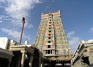
Virudhunagar District is an administrative district of Tamil Nadu state in southern India. Virudhunagar is the district headquarters and the largest city in Virudhunagar district is Rajapalayam. Virudhunagar district was formed by the separation of Old Ramanathapuram District in 1987 into Ramanathapuram District, Sivagangai District and the west part as Virudhunagar District. Virudhunagar District was formerly called Karmavirer Kamarajar District. As of 2011, Virudhunagar district had a population of 2,105,930 with a sex-ratio of 1,007 females for every 1,000 males.
India, also known as the Republic of India, is a country in South Asia. It is the seventh-largest country by area, the second-most populous country, and the most populous democracy in the world. Bounded by the Indian Ocean on the south, the Arabian Sea on the southwest, and the Bay of Bengal on the southeast, it shares land borders with Pakistan to the west; China, Nepal, and Bhutan to the northeast; and Bangladesh and Myanmar to the east. In the Indian Ocean, India is in the vicinity of Sri Lanka and the Maldives; its Andaman and Nicobar Islands share a maritime border with Thailand and Indonesia.
Tamil Nadu, formerly Madras State, is one of the 29 states of India. Its capital and largest city is Chennai. Tamil Nadu lies in the southernmost part of the Indian subcontinent and is bordered by the union territory of Puducherry and the South Indian states of Kerala, Karnataka, and Andhra Pradesh. It is bounded by the Eastern Ghats on the north, by the Nilgiri Mountains, the Meghamalai Hills, and Kerala on the west, by the Bay of Bengal in the east, by the Gulf of Mannar and the Palk Strait on the southeast, and by the Indian Ocean on the south. The state shares a maritime border with the nation of Sri Lanka.
In the 2001 Indian census, [1] Pallapatti had a population of 24,319; of this males and females were each 50%. Pallapatti has an average literacy rate of 68%, higher than the national average of 59.5%: male literacy is 76%, and female literacy is 61%. In Pallapatti, 13% of the population is under 6 years of age. The only lived community in Pallapatti is Devendra Kula Velalar. No other community people were lived. [ citation needed ]
A census is the procedure of systematically acquiring and recording information about the members of a given population. This term is used mostly in connection with national population and housing censuses; other common censuses include agriculture, business, and traffic censuses. The United Nations defines the essential features of population and housing censuses as "individual enumeration, universality within a defined territory, simultaneity and defined periodicity", and recommends that population censuses be taken at least every 10 years. United Nations recommendations also cover census topics to be collected, official definitions, classifications and other useful information to co-ordinate international practice.
Karimganj is a city in the Karimganj District of the Indian state of Assam. It is the administrative headquarters and main city of the district.
Puduvayal is a town in Karaikudi taluk, Sivaganga district in the Indian state of Tamil Nadu. It is a town located in the Chettinad region of the Sivagangai district. On road, it is 12 km away from Karaikudi and 21 km away from Aranthangi. This town is famous for its rice mills. Puduvayal is the 2nd largest rice producer in Tamil Nadu. Puduvayal is an important commercial centre for trade in the Sivaganga district and part of the suburban region of Karaikudi. The town is famous for its Veerasekara Umaiyambigai Temple. Nearby Kandanur is famous for Kandanur Sivan Kovil--which is a replica of the Madurai Meenakshi Temple--built by Nagarthars.
Desur is a Town panchayat in Tiruvanamalai district in the Indian state of Tamil Nadu.
Kappiyarai is a panchayat town in Kanniyakumari district in the Indian state of Tamil Nadu.
Kuju is a census town in Mandu of Ramgarh district in the Indian state of Jharkhand.
Lahar is a town and a Nagar Panchayat in Bhind district in the Indian state of Madhya Pradesh.
Lohta is a census town in Varanasi district in the Indian state of Uttar Pradesh.
Mahu Kalan is a census town in Sawai Madhopur district in the Indian state of Rajasthan.Arti Gurjar is Sarpanch in Mahukalan Panchayat at Present. Mainly Gurjar and Mali cast dominantly Residing in village. Former sarpanch Hansraj Gurjar also a dominant candidate and actively present himself as a developing man in various task regarding village Mahukalan.
Mullanpur Garibdass is a small town in Mohali district in the Indian state of Punjab, north of the city of Chandigarh. Garibdas village is located in vicinity of this town.
Naranammalpuram is a panchayat town in Tirunelveli district in the Indian state of Tamil Nadu.
Peerkankaranai is a town in Southern part of the metropolitan city of Chennai in the Indian state of Tamil Nadu.
Ranapur is a town and a nagar panchayat in Jhabua district in the Indian state of Madhya Pradesh.
Salumbar is a small town and a municipality in Udaipur district in the Indian state of Rajasthan. It was ruled by the Chundawat Sisodia rajputs of Mewar.
Sijhua is a census town in Chandrapura in Bermo subdivision of Bokaro district in the Indian state of Jharkhand.
Singaperumal Kovil is a census town located close to Chengalpet and Maraimalai Nagar in Chengalpattu taluk, Kancheepuram district in the Indian state of Tamil Nadu.
Surendranagar Dudhrej is a municipality in Surendranagar district in the Indian state of Gujarat. mainly Dudhrej municipality is directly connected with wadhwan city and wadhwan municipality.
Talai is a town and a nagar panchayat in Bilaspur district in the Indian state of Himachal Pradesh.
Varca is a census town in South Goa district in the Indian state of Goa.
Vasna is a town and an Industrial Notified Area of the Borsad municipality in Anand district in the Western Indian state of Gujarat.
Orla is a census town in Mandu of Ramgarh district in the Indian state of Jharkhand.
This article related to a location in Virudhunagar district, Tamil Nadu, India is a stub. You can help Wikipedia by expanding it. |