Calf of Man is a 2.50-square-kilometre (618-acre) island, off the southwest coast of the Isle of Man. It is separated from the Isle of Man by a narrow stretch of water called the Calf Sound. Like the nearby rocky islets of Chicken Rock and Kitterland, it is part of the historic parish of Rushen and the current parish district of Arbory and Rushen. It has only two seasonal inhabitants. The word 'calf' derives from the Old Norse word kalfr which means a small island lying near a larger one. One can reach the Calf of Man by boat from either Port Erin or Port St Mary. Cow Harbour and South Harbour are the main landing places. The highest part of the island is in the west where an unnamed peak reaches 126 m (415 ft) above sea level.

Fajardo is a town and a municipality part of the San Juan-Caguas-Fajardo Combined Statistical Area in Puerto Rico.
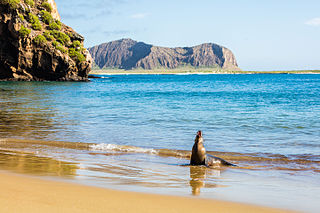
The Galápagos Islands are an archipelago of volcanic islands in the Eastern Pacific, located around the Equator 900 km (560 mi) west of South America. They form the Galápagos Province of the Republic of Ecuador, with a population of slightly over 33,000 (2020). The province is divided into the cantons of San Cristóbal, Santa Cruz, and Isabela, the three most populated islands in the chain. The Galápagos are famous for their large number of endemic species, which were studied by Charles Darwin in the 1830s and inspired his theory of evolution by means of natural selection. All of these islands are protected as part of Ecuador's Galápagos National Park and Marine Reserve.

Callao is a Peruvian seaside city and region on the Pacific Ocean in the Lima metropolitan area. Callao is Peru's chief seaport and home to its main airport, Jorge Chávez International Airport. Callao municipality consists of the whole Callao Region, which is also coterminous with the Province of Callao. Founded in 1537 by the Spaniards, the city has a long naval history as one of the main ports in Latin America and the Pacific, as it was one of vital Spanish towns during the colonial era. Central Callao is about 15 km (9.3 mi) west of the Historic Centre of Lima.
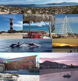
Bahía de los Ángeles is a coastal bay on the Gulf of California, located along the eastern shore of the Baja California Peninsula in the state of Baja California, Mexico. The town of the same name is located at the east end of Federal Highway 12 about 42 miles (68 km) from the Parador Punta Prieta junction on Federal Highway 1. The area is part of the San Quintín Municipality.

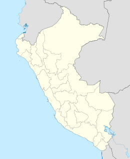
The administrative divisions of Peru have changed from time to time since the nation gained independence from Spain in the early 19th century. The old territorial subdivisions have split or merged due to several reasons, the most common ones being the need for decentralization and population increase, especially in Lima.

Isla Salas y Gómez, also known as Isla Sala y Gómez, is a small uninhabited Chilean island in the Pacific Ocean. It is sometimes considered the easternmost point in the Polynesian Triangle.
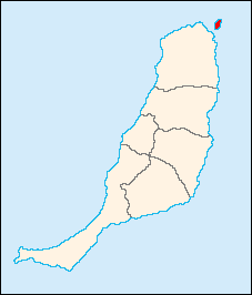
Lobos is a small island of the Canary Islands (Spain) located just 2 kilometres north of the island of Fuerteventura. It belongs to the municipality of La Oliva on the island of Fuerteventura. It has an area of 4.68 square kilometres (1.8 sq mi). It has been a nature reserve since 1982.

The Columbretes Islands (Valencian: Les Columbretes, IPA:[leskolumˈbɾetes] or Els Columbrets, are a group of small uninhabited islets of volcanic origin, in the Mediterranean Sea, 49 kilometres off Orpesa. Administratively they belong to Castellón de la Plana in the Valencian Community.

Navarino Island is a Chilean island located between Isla Grande de Tierra del Fuego, to the north, and Cape Horn, to the south. The island forms part of the Commune of Cabo de Hornos, the southernmost commune in Chile and in the world, belonging to Antártica Chilena Province in the XII Region of Magallanes and Chilean Antarctica. Its population is concentrated primarily in the communal capital, Puerto Williams, and in small settlements like Puerto Navarino, Río Guanaco and Puerto Toro. The highest point of the island is Pico Navarino at 1,195 m (3,921 ft). The island is a popular destination for fly-fishers.

Guafo Island is an island located southwest of Chiloé Island and northwest of Chonos Archipelago, Chile. This location and the prevailing westerly winds bring frequent rainstorms to the island. Ocean currents bring an abundance of fish into this area, making it one of the most productive marine areas in the Southern Pacific Ocean. Because of this, numerous marine vertebrates such as fur seals, sea lions and penguins come to the island to feed and reproduce.

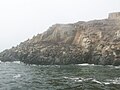
Isla Blanca or Blanca Island is a volcanic island located at the mouth of Chimbote Bay, near Chimbote, Peru. Administratively it is in Chimbote District, Santa Province, Ancash Region. The island is approximately 3200 m long and 920 m wide. It rises to an altitude of 204 m. Its relief is very rough and rocky. The contours are very steep, especially on the west side of the island. The island is white in appearance due to the deposition of guano by seabirds.

Sa Dragonera is an uninhabited islet in the Balearic Islands, Spain, located just off the west coast of Majorca. It is currently a natural park.

The Isla de Lobos is a small island located about 8 kilometres (5.0 mi) southeast of Punta del Este (Uruguay). An islet lies east of the island.

San Lorenzo Island is the largest island of Peru. The island is in the Pacific Ocean near the port of Callao and measures 16.5 square kilometres (6.4 sq mi).

The Palaui Island Protected Landscape and Seascape is an island that is a protected area and national park in the municipality of Santa Ana in Cagayan, Philippines. It is located off the northeastern extremity of Luzon Island.

Mouro Island, originally Mogro Island, is a small uninhabited island in the Bay of Biscay, located off the Magdalena Peninsula. It lies close to the entrance to the Bay of Santander near the city of Santander, Cantabria along the north coast of Spain. The island is approximately 2 hectares (0.02km²) and lies about .75 km from the entrance to the harbor.

The Ballestas Islands are a group of small islands near the town of Paracas within the Paracas District of the Pisco Province in the Ica Region, on the south coast of Peru.

The Pachacámac Islands, also known as Cavillaca Islands or as Whale Islands, are a group of islands located in the Pacific Ocean, off the coast of Lurín District, in Lima Province, Peru. Its formed by two main islands and three islets.