Related Research Articles

Popocatépetl is an active stratovolcano located in the states of Puebla, Morelos, and Mexico in central Mexico. It lies in the eastern half of the Trans-Mexican volcanic belt. At 5,393 m (17,694 ft) it is the second highest peak in Mexico, after Citlaltépetl at 5,636 m (18,491 ft).
Gilman is a town in Pierce County, Wisconsin, United States. The population was 772 as of the 2000 census. The unincorporated communities of Olivet and Viking are partially located in the town.

The Trans-Mexican Volcanic Belt, also known as the Transvolcanic Belt and locally as the Sierra Nevada, is an active volcanic belt that covers central-southern Mexico. Several of its highest peaks have snow all year long, and during clear weather, they are visible to a large percentage of those who live on the many high plateaus from which these volcanoes rise.

La Paz is a municipality in the State of Mexico, Mexico, with its municipal seat in the town of Los Reyes Acaquilpan. It is located on the dividing line between Mexico State and the eastern edge of the Federal District and is part of the Greater Mexico City area. The area was part of a region called "Atlicpac" which in Náhuatl means 'above or at the edge of water.' The current city's/municipality's glyph symbolizes water.
Paso de Cortés is a mountain pass between the Popocatépetl and Iztaccihuatl volcanoes in central Mexico. It is part of the Trans-Mexican Volcanic Belt, at a point where the southeast-trending continental divide turns north for over 16 km (10 mi). The altitude of the pass is about 3,400 m (11,200 ft), and serves as the access point to Izta-Popo Zoquiapan National Park. The pass is located in the municipality of Amecameca in the State of México, about 90 km (56 mi) southeast of Mexico City.

San Francisco Tetlanohcan is a town in the Mexican state of Tlaxcala, at the foot of the La Malinche dormant volcano. San Francisco Tetlanohcan has a population of 10,000 inhabitants, and is located about 20 minutes east of the state capital, Tlaxcala, Tlaxcala.
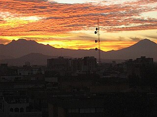
Venustiano Carranza is a small city located in the northwestern part of the Mexican state of Michoacán, in the region of the Chapala Lake. The city is still better known for its former pre-Mexican revolution name San Pedro Cahro, which derives from the town's patron saint and the last name of its original founders. Important spots in the town near the central square include a 17th-century church which has a clock tower. La Plaza is a town square structure that was recently renovated in 2005, which is packed on Sundays and town holidays and El Arco. There is a main farmer's market next to the municipal building and also a supermarket across the street. You can see mountains in the southeast part of town rumored to have a huge cross on a spot were La Virgin de Gaudalupe was seen.

Iztaccíhuatl–Popocatépetl National Park, also known as Izta-Popo Zoquiapan National Park, is a national park in Mexico on the border of the states of México, Puebla, and Morelos. The park protects 39,819.08 hectares, surrounding Mexico's second- and third-highest peaks, the Popocatépetl and Iztaccíhuatl volcanoes as well as the area of the Hacienda de Zoquiapán, and its annexed areas (anexas) of Zoquiapan, Ixtlahuacán, and the Frío de Juárez River.
Amozoc de Mota is a city located in the Mexican state of Puebla, Mexico. Its borders are in the north, the Malintzin volcano; in the south, the "Sierra de Amozoc"; in the west, the Acajete municipal seat; and in the west, the capital of the State Puebla city. Amozoc city is the seventh largest in the State, of Puebla, with a 2005 census population of 60,517 inhabitants.

The Federal Correctional Institution, Bastrop is an administrative-low-security United States federal prison for male inmates in Camp Swift, Texas. It is operated by the Federal Bureau of Prisons, a division of the United States Department of Justice. The facility also has an adjacent satellite prison camp that houses minimum-security offenders.
La Malinche National Park is located in the states of Puebla and Tlaxcala in Central Mexico. The park is east of Mexico City, and about 44 kilometres (27 mi) from the capital city
Tlaxcala, Tlaxcala.
Janówek is a village in the administrative district of Gmina Tolkmicko, within Elbląg County, Warmian-Masurian Voivodeship, in northern Poland. It lies approximately 2 kilometres (1 mi) south-west of Tolkmicko, 25 km (16 mi) north of Elbląg, and 88 km (55 mi) north-west of the regional capital Olsztyn.

Calpan Municipality is a municipality in the Mexican state of Puebla in south-eastern Mexico.

Huaquechula Municipality is a municipality in Puebla in south-eastern Mexico.

Puebla Municipality is a municipality in the State of Puebla in eastern Central Mexico. The municipality covers a total area of 534.32 square kilometres (206.30 sq mi). The City of Puebla is the municipal seat, as well as the capital of the state.
San Nicolás Buenos Aires is a town and municipality in the Mexican state of Puebla in south-eastern Mexico.
Sandy Point is an unincorporated community in Northumberland County, in the U.S. state of Virginia.
Río Frío de Juárez, originally Río Frío, a Mexican populated place, is located in the municipality of Ixtapaluca in the State of Mexico. Río Frío de Juárez is located at the highest point on the highway between Mexico City to Puebla de Zaragoza being located at the top of the pass on the historic road between the two cities.
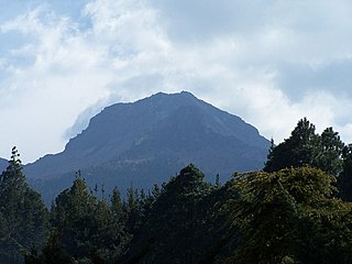
Altzomoni is a volcanic peak located in the State of Mexico. Situated between the volcanoes Popocatépetl and Ixtaccíhuatl in the northern portion of the Paso de Cortés, Altzomoni rises 4,200 metres (13,800 ft) above sea level. It is located inside Izta-Popo Zoquiapan National Park.
Chandler is an unincorporated community in Wayne Township, Jefferson County, Ohio, United States. It is located south of Bloomingdale at the intersection of Bloomingdale-Smithfield-Chandler Road and County Road 24, at 40°18′28″N80°48′15″W.
References
- ↑ "Papayo". Global Volcanism Program . Smithsonian Institution . Retrieved 2021-06-27.
- ↑ "Papayo". www.volcanodiscovery.com. Retrieved 2019-06-13.
| Authority control databases: Geographic |
|---|
19°18′28″N98°41′55″W / 19.30778°N 98.69861°W
| | This Mexico location article is a stub. You can help Wikipedia by expanding it. |