
Santacruz or Santa Cruz is a suburb of Mumbai. The Santacruz railway station on the Mumbai Suburban Railway, the domestic terminal (T1) of the Chhatrapati Shivaji Maharaj International Airport, and one campus of the University of Mumbai, are all located in Santacruz (East).
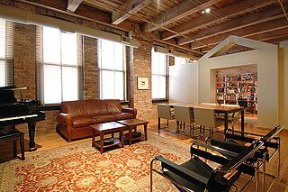
A loft is a building's upper storey or elevated area in a room directly under the roof, or just an attic: a storage space under the roof usually accessed by a ladder. A loft apartment refers to large adaptable open space, often converted for residential use from some other use, often light industrial. Adding to the confusion, some converted lofts themselves include upper open loft areas.
Besant Nagar is an upscale, exclusive residential neighbourhood in South Chennai, India. It is located along the coast of Bay of Bengal.

Thyagaraya Nagar, commonly known as T. Nagar, and historically known as East Mambalam, is a very affluent commercial and residential neighbourhood in Chennai, Tamil Nadu, India. It is surrounded by Nungambakkam in the North, Teynampet in the East, Nandanam in the South-East, C.I.T. Nagar in the South and West Mambalam and Kodambakkam in the West. The stretch between Duraiswamy Road and T. Nagar Bus Stand has some of the costliest real estates in Chennai. It was constructed between 1923 and 1925 by the Madras Presidency government of the Raja of Panagal as a part of town planning activities initiated according to the Madras Town Planning Act of 1920. The town was named after P. Thyagaraya Chetty. The streets, parks and localities in the new neighbourhood were named after important officials in the provincial government.

Basaveshwaranagara, also known as Basaveshwaranagar, Basaveshnagara or Basaveshnagar is a largely residential neighbourhood in the west of Bengaluru, Karnataka, India. It is located to the west of Rajajinagara and is sandwiched between the localities of Mahalakshmi Layout to the north and Vijayanagara to the south, spread across multiple sub-localities, three assembly constituencies and seven Bruhat Bengaluru Mahanagara Palike (BBMP) wards. The area of Basaveshwaranagara is often considered West of Chord Road as it lies to the west of Chord Road, an arterial road in the western part of Bengaluru.
Virugambakkam is a residential neighbourhood of Chennai, Tamil Nadu, India. It is an important residential area of and is famous for its schools, market, residential colonies and residences of film artists. Virugambakkam had some of Chennai's oldest film studios.
Sunder Nagar is a small area lying within the suburban region of Malad–Goregaon in Mumbai, India. It lies in west of the arterial Swami Vivekanand Road and is mostly a residential neighbourhood. It was built up in the 1970s during the city's population and construction boom. The name Sunder Nagar means "beautiful place" in Hindi. There was a community called "Vijaykar Wadi" before 1970 and its name was changed to "Sunder Nagar". "Wadi" means group of trees, there were many "Mango" and "Chikoo" trees in the area, still some can be seen in the park maintained by "The Sunder Nagar Welfare Association".
K.K. Nagar is a neighbourhood located in the southern part of Chennai, India. This is situated west of Ashok Nagar and the Chennai Airport is around 10 km southwest of this place. K.K. Nagar was a locality developed in the 1970s and early 1980s. K.K. Nagar is roughly 5 km2 in area. K.K. Nagar is organized by sectors and streets, and there are 15 sectors, and around 102 streets.

Dr S. K. Karim Khan Road, commonly known as 100 Feet Road Indira Nagar. It is a road in the Indian city of Bangalore that links Old Madras Road with Old Airport Road.

ShahdaraDistrict is an administrative and revenue district of Delhi, India, situated near the banks of Yamuna river. The district headquarters is Nand Nagri. The Shadara District is also a home for Shahdara area Which is closely located to Chandni chowk in Central Delhi, Situated close it's edge with Uttarpradesh state Ghaziabad District the area is commonly known as Apsara or Shahdara border.It is one of the oldest inhabited areas of Delhi and integral to what is known as Purani Dilli. Shahdara district was formed in 2012 and has a collectorate office at Nand Nagri, Delhi.

Chennai is located at 13.04°N 80.17°E on the southeast coast of India and in the northeast corner of Tamil Nadu. It is located on a flat coastal plain known as the Eastern Coastal Plains. The city has an average elevation of 6 metres (20 ft), its highest point being 60 m (200 ft). Chennai is 2,184 kilometres south of Delhi, 1,337 kilometres southeast of Mumbai, and 1,679 kilometers southwest of Kolkata by road.
A. S. Rao Nagar, also known as Dr. A. S. Rao Nagar, is a major commercial and residential neighbourhood of Hyderabad, Telangana, India. It is located in the north eastern side of the city falling under Kapra Village & Mandal, Medchal-Malkajgiri district. It is administered as Ward No. 2 of Greater Hyderabad Municipal Corporation.
K. K. Nagar or Kalaignar Karunanidhi Nagar is a residential part of Tiruchirappalli City in Tamil Nadu, India. The K.K. Nagar neighbourhood is near the Tiruchirappalli International Airport, and is the most densely populated ward in the city and also the most populous ward in the city of Tiruchirapalli. It is a part of T.C.C since 1994.

Ramamurthy Nagar ( ) is an area in Bangalore in the Indian state of Karnataka. It is located in the north-eastern part of Bangalore and comes under the E3 subdivision of BBMP. It is a rapidly growing suburb, adjacent to other areas such as Banaswadi, CV Raman Nagar and Krishnarajapuram, also officially called Krishnarajapura.
Rajbagh is the notified area in the municipal committee of Srinagar, in the Indian union territory of Jammu and Kashmir. It comes under the Amira Kadal Constituency. Rajbagh is a posh locality in the civil line area of Srinagar. The postal code of Rajbagh is 190008. Rajbagh is considered one of the many best residential places in Srinagar. There are many hotels, restaurants and schools in this locality. Rajbagh area was heavily damaged by the 2014 Kashmir floods, it was one of the worst affected areas due to flood.

Thindlu, once an ancient village, is now a part of the Bangalore North. Thindlu is famous for its ancient temple of lord Virabhadra and is currently a thriving community with many real estate constructions. Thindlu comes under Vidyaranyapura ward of Byatarayanapura constituency. Byatarayanapura is one of the largest constituency of Bangalore. Many residential layouts have recently come up. Thindlu is located to the east of Vidyaranyapura and to the west of Sahakara Nagar. Once a rural village, it has now become very well integrated to Bengaluru city style. With many new residential apartments and with the influx of people this area does not resemble anymore like an rural village, although some areas still retain Village type old houses. Although declining, Animal husbandry can still be witnessed here like any other part of Bangalore Rural district.
Changampuzha Nagar is a prominent and planned residential area in Kalamassery in the city of Kochi, Kerala, India. The Residential area lies between Kalamassery municipal town hall and Pathadippalam near the National Highway 544 and is the major residential area in Kalamassery and Ernakulam. Changampuzha Nagar was developed by Kerala State Housing Board in 1975 and named after the great poet Changampuzha Krishna Pillai. There are about 600 houses in Changampuzha nagar with three children's parks one football ground, School building, Post Office, Ration shop, recreation club, Indoor shuttle court, library, clean and wide roads. This was once a rubber estate with an area, developed into a colony in the 70's, with houses developed into three types, EWS, LIG and MIG residential houses made like Panampilly Nagar and Gandhi Nagar, Kochi.
Indira Nagar is a residential area in the city of Srinagar in the Indian union territory of Jammu and Kashmir. It used to be a lake before but now only few hundred meters of the lake is left.
Jawahar Nagar is the notified area in the municipal committee of Srinagar, in the Indian administered union territory of Jammu and Kashmir. It comes under the Amira Kadal Constituency. Jawahar Nagar is a posh locality in the civil line area of Srinagar. The postal code of Jawahar Nagar is 190008. Jawahar Nagar is considered one of the many best residential places in Srinagar. The airport is located at a distance of 9.3 km (5.8 mi). Jawahar Nagar area was heavily damaged by the 2014 Kashmir floods, it was one of the worst affected areas due to flood. There are two Branches of Jammu and Kashmir Bank, one of which is exclusively for women. There are multiple gymnasiums, mosques and shops in the area.