
The São Francisco River is a large river in Brazil. With a length of 2,914 kilometres (1,811 mi), it is the longest river that runs entirely in Brazilian territory, and the fourth longest in South America and overall in Brazil. It used to be known as the Opara by the indigenous people before colonisation, and is today also known as "Velho Chico".
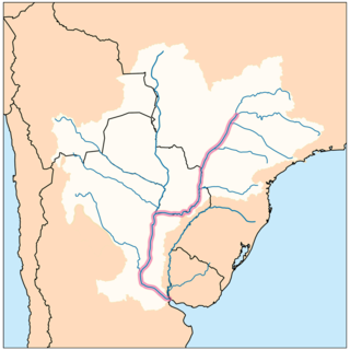
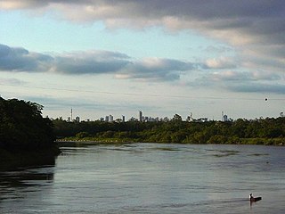
The Paraná River is a river in south-central South America, running through Brazil, Paraguay, and Argentina for some 4,880 kilometres (3,030 mi). Among South American rivers, it is second in length only to the Amazon River. It merges with the Paraguay River and then farther downstream with the Uruguay River to form the Río de la Plata and empties into the Atlantic Ocean.

Itatiaia National Park, established in 1937, is the oldest national park in Brazil. It is located on the border between the states of Rio de Janeiro and Minas Gerais.

Boa Esperança is a Brazilian municipality from the state of Minas Gerais. The municipality is located by the Serra da Boa Esperança, which became celebrated through song that brings its name, compounded by Lamartine Babo and performed by several singers. Across its territory passes Rio Grande, important to the development of the region. The economy of Boa Esperança is based on coffee plantations and tourism.

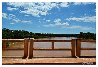
Rio Grande is a river in south-central Brazil. It rises in the Mantiqueira Mountains in the state of Minas Gerais and descends inland, west-northwestward. Its lower course marks a portion of the Minas Gerais-São Paulo border. At the Mato Grosso do Sul state border, after a course of 1,090 km (677 mi), it joins the Paranaíba River to form the Upper Paraná River.

Três Pontas is a municipality located in southern Minas Gerais state, Brazil. It's a city with about all streets of urban zone paved and services of water and sewage to all people. The municipality has about 57 thousand inhabitants and a population density of 78,12hab/km2. The road MG-167 is the only paved road that passes through the city, but the Rodovia Fernão Dias (BR-381), is less than 50 km from the city centre passing through Varginha.

The Paraíba do Sul, or simply termed Paraíba, is a river in southeast Brazil. It flows 1,137 km (706 mi) west to northeast from its farthest source at the source of the river Paraitinga to the sea near Campos dos Goytacazes. The river receives its name when it meets the river Paraibuna at the Paraibuna dam.

The Doce River is a river in southeast Brazil with a length of 853 kilometres (530 mi). The river basin is economically important. In 2015 the collapse of a dam released highly contaminated water from mining into the river, causing an ecological disaster.

The Paranaíba River is a Brazilian river whose source lies in the state of Minas Gerais in the Mata da Corda mountains, municipality of Rio Paranaíba, at an altitude of 1,148 meters; on the other face of this mountain chain are the sources of the Abaeté river, tributary of the São Francisco River. The length of the river is approximately 1,000 kilometres (620 mi) up to the junction with the Grande River, both of which then form the Paraná River, at the point that marks the borders of the states of São Paulo, Minas Gerais, and Mato Grosso do Sul.
The Paracatu River is located mainly in the state of Minas Gerais in Brazil. It is the longest tributary of the São Francisco, draining a basin of about 45,000 km2, including 21 municipalities and the Federal District. The basin is almost completely located in the state of Minas Gerais, including only three municipalities in the state of Goiás.

Oliveira is a Brazilian municipality in the state of Minas Gerais. It is located at latitude 20º41'47" south and longitude 44º49'38" west, at an altitude of 982 metres. It is located 165 kilometres at southwest from Belo Horizonte. Its estimated population was 41,181 according to the latest IBGE census.

Arantina is a Brazilian municipality located in the state of Minas Gerais. Its population as of 2020 is estimated to be 2,787 people living in a total area of 89.382 km². The city belongs to the mesoregion of Sul and Sudoeste de Minas and to the microregion of Andrelândia.

Brumadinho is a Brazilian municipality in the state of Minas Gerais. The city belongs to the Belo Horizonte metropolitan mesoregion and to the microregion of Belo Horizonte. Brumadinho is at an altitude of 880 m. In 2020 the population was 40,666. The municipality is on the Paraopeba River.
The Cuiabá River is a Brazilian river in the western state of Mato Grosso that flows in the Río de la Plata Basin. It is a tributary of the São Lourenço River.

The das Velhas River, is by length the major tributary of the basin of the São Francisco river. Its water flows into that river at a place called Barra do Guaicuí, in the municipality of Várzea da Palma, Minas Gerais. The source was found to be the Andorinhas waterfall located in the municipality of Ouro Preto.

The Araçuaí River is a river of Minas Gerais state in southeastern Brazil. The Araçuaí River flows through the Jequitinhonha Valley in the northeast of Minas Gerais, through the town of Araçuaí, which the river takes its name from. It is a tributary of the Jequitinhonha River, flowing south from its right bank. The confluence of the river is located at 16°45′45″S42°0′32″W. Tributaries include the Gravatá River, Setúbal River, Capivara River, Fanado River and the Itamarandiba River.

The Ribeira de Iguape River, or simply the Ribeira River, is a river of Paraná and São Paulo states in southeastern Brazil. It flows into the Atlantic Ocean near Iguape. The river is home to several endemic species of fish. So far no dams have been built on the river, although four have been proposed. Although it flows through a relatively sparsely populated region with untouched areas of Atlantic Forest, the river has been contaminated with heavy metals from mining beyond the point where it is considered safe to eat the molluscs found in the river and its estuary.
The Volta Grande Dam is an embankment dam on the Grande River about 12 kilometres (7.5 mi) west of Água Comprida, Brazil. The dam is on the border of Conceição das Alagoas municipality in the state of Minas Gerais to the north and Miguelópolis municipality in the state of São Paulo to the south. It was constructed between 1970 and 1974 for the purpose of hydroelectric power generation. The power station at the dam has an installed capacity of 380 MW and is owned by CEMIG.

Serra do Gandarela National Park is a national park in the state of Minas Gerais, Brazil. It protects a mountainous region holding a remnant of Atlantic Forest that is an important source of water for the city of Belo Horizonte.

The Brumadinho dam disaster occurred on 25 January 2019 when a tailings dam at the Córrego do Feijão iron ore mine suffered a catastrophic failure. The dam, located 9 kilometres (5.6 mi) east of Brumadinho in Minas Gerais, Brazil, is owned by the mining company Vale, which was also involved in the Mariana dam disaster of 2015. The collapse of the dam released a mudflow that engulfed the mine's headquarters, including a cafeteria during lunchtime, along with houses, farms, inns, and roads downstream. 270 people died as a result of the collapse, of whom 259 were officially confirmed dead, in January 2019, and 11 others reported as missing, whose bodies had not been found.
