
Burra Parish located at 32°42′54″S147°24′04″E / 32.715000°S 147.401111°E is a cadastral parish in Kennedy County New South Wales. [1]
Burra Parish is located between Fifield and Tullamore, New South Wales.
Burra Parish located at 32°42′54″S147°24′04″E / 32.715000°S 147.401111°E is a cadastral parish in Kennedy County New South Wales. [1]
Burra Parish is located between Fifield and Tullamore, New South Wales.

Mount Tilga, a hill located near Condobolin in the Central West region of New South Wales, Australia, was said to be the exact centre of New South Wales.
The Billabong Creek, a perennial river of the Murrumbidgee catchment within the Murray–Darling basin, is located in the South West Slopes region of New South Wales, Australia.
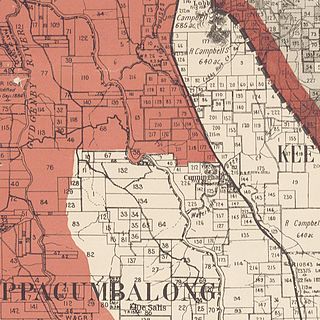
Keewong Parish is a parish of Murray County, New South Wales, a cadastral unit for use on land titles. A small part of the north-western end of the parish around 35°34′40″S149°07′28″E between the Murrumbidgee River and the Queanbeyan-Cooma railway line was transferred to the Australian Capital Territory in 1909. The southern ends of portions 177, 218, 211, 36, and 38 in the Parish of Keewong form part of the border of the ACT with New South Wales, which is mentioned in the Seat of Government Acceptance Act of 1909.
Burra may refer to:

East Wagga Wagga is a suburb of Wagga Wagga, New South Wales. East Wagga Wagga is mostly an industrial area located approximately 3 km (2 mi) east south-east of the central business district on the Sturt Highway. Home Base Wagga Wagga, WIN Television, Country Energy depot, Riverina Water County Council headquarters, Australia Post Mail Sorting Centre, Busabout Wagga Wagga depot, Australian Clay Target Association (ACTA) National Office and ACTA shooting range are located within East Wagga Wagga.
The parish of Doonside is an Australian cadastral parish in the NSW county of Narromine. It is located approximately midway between Tottenham and Narromine and is in Narromine Shire. The parish should not be confused with the western Sydney suburb of Doonside.
The parish of Algalah is an Australian cadastral parish in the NSW county of Narromine. It is located 367km west north west from Sydney approximately midway between Tottenham and Narromine and is in Narromine Shire, at 32°14′54″S147°49′04″E.
Binna Burra is a rural locality in the Scenic Rim Region, Queensland, Australia. It borders New South Wales. In the 2021 census, Binna Burra had "no people or a very low population".
The Burra Creek, a mostly–perennial river that is part of the Murrumbidgee catchment within the Murray–Darling basin, is located in the South West Slopes region of New South Wales, Australia.
The Burra Creek, a mostly–perennial river that is part of the Murrumbidgee catchment within the Murray–Darling basin, is located in the Monaro and Southern Tablelands regions of New South Wales, Australia.
Wharfdale is a bounded rural locality, and cadastral parish south of Nyngan and west of Tottenham, New South Wales.

Babathnil located at 32°31′54″S 147°26′04″ is acadastral parish in Kennedy County New South Wales.
Belardery is a cadastral parish in Kennedy County, New South Wales.
Beugamel located at 32°39′54″S 147°47′04″ is a cadastral parish in Kennedy County New South Wales.
Bentinck located at 32.2954°S 147.3704°E is a cadastral parish in Kennedy County New South Wales.
Carolina located at 32°09′54″S 147°26′04″e is a cadastral parish in Kennedy County New South Wales.
Euchabil located at 32°40′54″S 147°52′04″ between Peak Hill, New South Wales and Tullamore, New South Wales is a cadastral parish of Kennedy County New South Wales.
Genanaguy is a cadastral parish of Kennedy County, New South Wales, Australia.
Ossory Parish located at 32°26′54″S 147°44′04″ is a cadastral parish of Kennedy County New South Wales.
Tabratong located at 32°14′54″S 147°27′04″ is a cadastral parish of Kennedy County New South Wales.
| | This New South Wales geography article is a stub. You can help Wikipedia by expanding it. |