

The Frederic Parish is a civil parish of the County of Cumberland.
The Parish is in the Hornsby Shire Council, on the Hawkesbury River. [2]
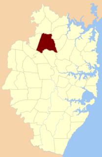
The Frederic Parish is a civil parish of the County of Cumberland.
The Parish is in the Hornsby Shire Council, on the Hawkesbury River. [2]

Westmorland is a historic county in North West England. It formed an administrative county between 1889 and 1974, after which the whole county was administered by the new administrative and ceremonial county of Cumbria. The people of Westmorland are known as Westmerians. In April 2023, it is planned that local government in Cumbria will be reorganised into two unitary authorities, one of which is to be named Westmorland and Furness and would cover all of the historic county along with parts of historic Yorkshire, Lancashire and Cumberland.
Cumberland is a historic county in North West England that had an administrative function from the 12th century until 1974. It is bordered by the historic counties of Northumberland to the north-east, County Durham to the east, Westmorland to the south-east, Lancashire to the south, and the Scottish counties of Dumfriesshire and Roxburghshire to the north. It formed an administrative county from 1889 to 1974 and now forms part of Cumbria. In April 2023, local government in Cumbria will be reorganised into two unitary authorities; one of these is to be named Cumberland and would include most of the historic county, with the exception of Penrith and the surrounding area.

Millom is a town and civil parish on the north shore of the estuary of the River Duddon in southwest Cumbria, historically part of Cumberland, England. It is situated just outside the Lake District National Park, about six miles north of Barrow-in-Furness and 26 mi (42 km) south of Whitehaven.

Cumberland County is a county in the State of New South Wales, Australia. Most of the Sydney metropolitan area is located within the County of Cumberland.

Aikton is a small village in the north of the English county of Cumbria. The nearest town is Wigton 3 miles away, and the nearest city is Carlisle at 8 miles. Aikton is located 5+1⁄2 miles (8.9 km) south of the Scottish border, in the centre of the Channel of the River Eden. It is in the historic county of Cumberland.

Lot 61 is a township in Kings County, Prince Edward Island, Canada. It is part of St. Andrew's Parish. Lot 61 was awarded to Richard Cumberland in the 1767 land lottery. It was sold to Laurence Sullivan in 1783.
Leath was one of the wards of the historic county of Cumberland in north west England. Unlike most other English counties, Cumberland was divided into wards rather than hundreds.

Frizington is a village in Cumbria, England, historically part of Cumberland, near the Lake District National Park.

For lands administrative purposes, New South Wales is divided into 141 counties, which are further divided into parishes. The counties were first set down in the Colony of New South Wales, which later became the Australian state of New South Wales.

Lands administrative divisions of Australia are the cadastral divisions of Australia for the purposes of identification of land to ensure security of land ownership. Most states term these divisions as counties, parishes, hundreds, and other terms. The eastern states of Queensland, New South Wales, Victoria, and Tasmania were divided into counties and parishes in the 19th century, although the Tasmanian counties were renamed land districts in the 20th century. Parts of South Australia (south-east) and Western Australia (south-west) were similarly divided into counties, and there were also five counties in a small part of the Northern Territory. However South Australia has subdivisions of hundreds instead of parishes, along with the Northern Territory, which was part of South Australia when the hundreds were proclaimed. There were also formerly hundreds in Tasmania. There have been at least 600 counties, 544 hundreds and at least 15,692 parishes in Australia, but there are none of these units for most of the sparsely inhabited central and western parts of the country.
Armathwaite is a village in the English ceremonial county of Cumbria.
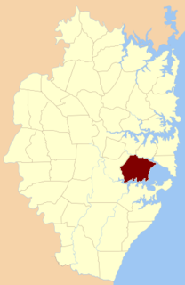
St George Parish is one of the 57 parishes of Cumberland County, New South Wales, a cadastral unit for use on land titles. It is bounded in the north by the Cooks River, in the west of Cox's Creek and Salt Pan Creek, and in the south by the Georges River.
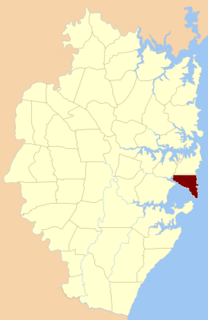
Botany Parish, Cumberland is one of the 57 parishes of Cumberland County, New South Wales, a cadastral unit for use on land titles. It contains the area to the north of Botany Bay and to the east of part of Cooks River. It includes the suburbs of La Perouse, Hillsdale, Banksmeadow and Maroubra. It also includes Sydney Airport. It roughly corresponds to the "South-Eastern Suburbs" of Sydney, which are sometimes counted as part of the Eastern Suburbs together with the suburbs in the Parish of Alexandria to the north.

Petersham Parish is one of the 57 parishes of Cumberland County, New South Wales, a cadastral unit for use on land titles. It is located to the south of Iron Cove, Rozelle Bay and the Parramatta River, and to the north of Cooks River. It includes the suburbs of Balmain, Leichhardt, Petersham, Newtown, Marrickville, Tempe, Glebe and St Peters. It roughly corresponds to the eastern half of the Inner West region, with the neighbouring Parish of Concord making up the western half.

Concord Parish is one of the 57 parishes of Cumberland County, New South Wales, a cadastral unit for use on land titles. It is located to the south of the Parramatta River between Homebush Bay and Iron Cove; and to the north of Cooks River. It includes the suburbs of Homebush, most of Strathfield, Burwood, Croydon, Concord, Canada Bay, Abbotsford and Drummoyne. It covers the local government areas of City of Canada Bay and the Municipality of Burwood and most of the Municipality of Strathfield. It roughly corresponds to the western half of the Inner West region, with the neighbouring Parish of Petersham making up the eastern half.

St John Parish is one of the 57 parishes of Cumberland County, New South Wales, a cadastral unit for use on land titles. It is named after St John's Cathedral in Parramatta, New South Wales which opened in 1803, on which the civil parish is roughly centred. The parish is shaped like a "T", with the northern part stretching from Toongabbie to the western shore of Homebush Bay. The southern end is at Prospect Creek near Yennora. Woodville Road and Parramatta Road form the boundaries to the south-east. The Old Prospect Road is part of the boundary in the west.

Cumberland Land District is one of the twenty land districts of Tasmania which are part of the cadastral divisions of Tasmania. It was formerly one of the 18 counties of Tasmania. It is bordered by the River Derwent to the south, the Clyde River to the east, with Lake Sorell at the north-eastern edge. The Nive River is the boundary to the west. Part of the Shannon River is a section of the boundary to the north, with Great Lake on the northern edge.

St. Ann's Church Complex is now a historic cultural center in Woonsocket, Rhode Island on Cumberland Street. It was formerly a Roman Catholic church within the Diocese of Providence.
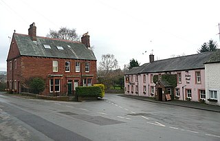
Distington is a large village and civil parish in Cumbria, England, 3 miles (4.8 km) south of Workington and 4 miles (6.4 km) north of Whitehaven. Historically a part of Cumberland, the civil parish includes the nearby settlements of Common End, Gilgarran and Pica. The parish had a population of 2,247 in the 2001 census, increasing slightly to 2,256 at the 2011 census.
Parish of Nelson, is a civil parish of the County of Cumberland, north west of Sydney, Australia.
| | This article related to the geography of Sydney is a stub. You can help Wikipedia by expanding it. |
| | This New South Wales geography article is a stub. You can help Wikipedia by expanding it. |