
Cumberland is a historic county in the north west of England. The historic county is bordered by Northumberland to the north-east, County Durham to the east, Westmorland to the south-east, Lancashire to the south, and the Scottish counties of Dumfriesshire and Roxburghshire to the north. The area includes the city of Carlisle, part of the Lake District and North Pennines, and the Solway Firth coastline.

Cumberland County is a county in the State of New South Wales, Australia. Most of the Sydney metropolitan area is located within the County of Cumberland.

The South Creek or Wianamatta is a creek that is part of the Hawkesbury-Nepean catchment, located on the Cumberland Plain in Greater Western Sydney, New South Wales, Australia.
South Windsor is a suburb of the town of Windsor in north west Sydney in the state of New South Wales, Australia. It is generally bounded in the west by Rickabys Creek and in the east by South Creek, both tributaries of the Hawkesbury River. It is also home of Bede Polding College, a Catholic secondary school.

Hawkesbury is an electoral district of the Legislative Assembly in the Australian state of New South Wales. It is represented by Robyn Preston of the Liberal Party.

The Cumberland Plain, also known as Cumberland Basin, is a relatively flat region lying to the west of Sydney CBD in New South Wales, Australia. An IBRA biogeographic region, Cumberland Basin is the preferred physiographic and geological term for the low-lying plain of the Permian-Triassic Sydney Basin found between Sydney and the Blue Mountains, and it is a structural sub-basin of the Sydney Basin.

Northumberland County was one of the original Nineteen Counties in New South Wales and is now one of the 141 cadastral divisions of New South Wales. It included the area to the north of Broken Bay, which compasses the Central Coast region and Lake Macquarie as well as Newcastle(Greater Newcastle) in the Hunter region. It was bounded by the part of the Hawkesbury River to the south, the Macdonald River to the south-west, and the Hunter River to the north.

St George Parish is one of the 57 parishes of Cumberland County, New South Wales, a cadastral unit for use on land titles. It is bounded in the north by the Cooks River, in the west by Cox's Creek and Salt Pan Creek, and in the south by the Georges River and in the east by Botany Bay.
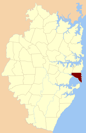
Botany Parish, Cumberland is one of the 57 parishes of Cumberland County, New South Wales, a cadastral unit for use on land titles. It contains the area to the north of Botany Bay and to the east of part of Cooks River. It includes the suburbs of La Perouse, Hillsdale, Banksmeadow and Maroubra. It also includes Sydney Airport.

Petersham Parish is one of the 57 parishes of Cumberland County, New South Wales, a cadastral unit for use on land titles. It is located to the south of Iron Cove, Rozelle Bay and the Parramatta River, and to the north of Cooks River. It includes the suburbs of Balmain, Leichhardt, Petersham, Newtown, Marrickville, Tempe, Glebe and St Peters. It roughly corresponds to the eastern half of the Inner West region, with the neighbouring Parish of Concord making up the western half.

Concord Parish is one of the 57 parishes of Cumberland County, New South Wales, a cadastral unit for use on land titles. It is located to the south of the Parramatta River between Homebush Bay and Iron Cove; and to the north of Cooks River. It includes the suburbs of Homebush, most of Strathfield, Burwood, Croydon, Concord, Canada Bay, Abbotsford and Drummoyne. It covers the local government areas of City of Canada Bay and the Municipality of Burwood and most of the Municipality of Strathfield. It roughly corresponds to the western half of the Inner West region, with the neighbouring Parish of Petersham making up the eastern half.
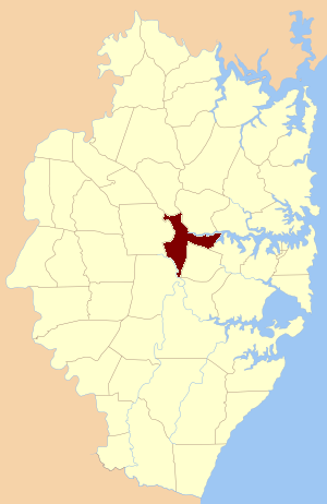
St John Parish is one of the 57 parishes of Cumberland County, New South Wales, a cadastral unit for use on land titles. It is named after St John's Cathedral in Parramatta, New South Wales which opened in 1803, on which the civil parish is roughly centred. The parish is shaped like a "T", with the northern part stretching from Toongabbie to the western shore of Homebush Bay. The southern end is at Prospect Creek near Yennora. Woodville Road and Parramatta Road form the boundaries to the south-east. The Old Prospect Road is part of the boundary in the west.
Cumberland was an electoral district of the Legislative Assembly in the Australian state of New South Wales in outer western Sydney named after Cumberland County. It was created as a three-member electorate with the introduction of proportional representation in 1920, replacing Camden and Hawkesbury. It was abolished in 1927 and replaced by Hawkesbury, Nepean, and parts of Bankstown, Lakemba and Hornsby.

St Lawrence Parish is one of the 57 parishes of Cumberland County, New South Wales, Australia, a cadastral unit for use on land titles. It is one of the four small parishes in the Sydney city area. Unlike the other three parishes, St Lawrence was not named after a New Testament saint but after St Lawrence, the second Bishop of Canterbury, successor to St Augustine of Canterbury, presumably very familiar to Bishop Broughton from his time in Canterbury. The church in the parish was dedicated by the bishop as Christ Church. Later, as it became more "tractarian" and Anglo-Catholic, the name of the parish was added to that of the church. However, by then, St Lawrence was understood to refer to the only saint of that name in the Book of Common Prayer, St Lawrence, of Rome, and St Laurence of Rome has since been considered the patron saint of the church..
The Paddys River, a perennial river that is part of the Hawkesbury-Nepean catchment, is located in the Southern Highlands region of New South Wales, Australia.
Robert Bruce Walker was an Australian politician.
Blaxland Creek, a watercourse that is part of the Hawkesbury–Nepean catchment, is located in Greater Western Sydney, Australia.

Parish of St Matthews, is one of the 57 civil parishes of the County of Cumberland, New South Wales.

The Parish of Berowra is a civil parish of the County of Cumberland, New South Wales, Australia.

The Parish of Cowan, is a civil parish of the County of Cumberland.

