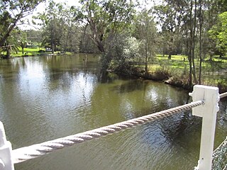
Dora River is a watercourse that is located in the Upper Central Coast/Lower Hunter regions of New South Wales, Australia.

Willoughby Parish, Cumberland is one of the 57 parishes of Cumberland County, New South Wales, Australia, a cadastral unit for use on land titles. The suburb of Willoughby and the City of Willoughby LGA are in a similar area.
St George Parish is one of the 57 parishes of Cumberland County, New South Wales, a cadastral unit for use on land titles. The name is used as the region name today.

Alexandria Parish is one of the 57 parishes of Cumberland County, New South Wales, a cadastral unit for use on land titles. It contains the area to the south and east of Sydney city including Bondi, Paddington and Clovelly. It was probably named after the Battle of Alexandria fought in 1801.

Petersham Parish is one of the 57 parishes of Cumberland County, New South Wales, a cadastral unit for use on land titles. It is located to the south of Iron Cove, Rozelle Bay and the Parramatta River, and to the north of Cooks River. It includes the suburbs of Balmain, Leichhardt, Petersham, Newtown, Marrickville, Tempe, Glebe and St Peters.

Concord Parish is one of the 57 parishes of Cumberland County, New South Wales, a cadastral unit for use on land titles. It is located to the south of the Parramatta River between Homebush Bay and Iron Cove; and to the north of Cooks River. It includes the suburbs of Burwood, Croydon, Concord, Canada Bay and Abbotsford.

Liberty Plains Parish is one of the 57 parishes of Cumberland County, New South Wales, a cadastral unit for use on land titles. It is bounded by Parramatta Road in the north; the area between Flemington and Homebush, all of Strathfield a small part of Cooks River and Liverpool Road in the east; the Hume Highway also in the south; and Woodville Road in the west. It includes the suburbs of Auburn, Regents Park, Potts Hill, Chester Hill, Bass Hill and Lidcombe. It also includes the Rookwood Cemetery. Before the parish was proclaimed in 1835, the Liberty Plains district was in the same area. The name had been given when the first settlers had desired a settlement midway between Parramatta and Sydney city. The name is still used on a motor inn in the area. In the 1851 census there were 49 houses and 270 people in the Liberty Plains parish.

Huntleys Cove is a suburb in the Northern Suburbs of Sydney, in the state of New South Wales, Australia. Huntleys Cove is located 9 kilometres north-west of the Sydney central business district, in the local government area of the Municipality of Hunter's Hill. Huntleys Cove sits on the peninsula between Tarban Creek and the Parramatta River.

St Philip Parish is one of the 57 parishes of Cumberland County, New South Wales, a cadastral unit for use on land titles. It is located on the western part of the original colony at Sydney Cove, which was to the west of the Tank Stream. It is one of the four small parishes in the Sydney city area and is named after the church of St Philip's. It includes the southern end of the Sydney Harbour Bridge, The Rocks, Dawes Point and Millers Point. It is bounded by Sydney Harbour in the north, King Street in the south, George Street in the south-east, and what was once the Tank Stream in the east. The northern end of Darling Harbour is the boundary in the west. It includes Wynyard railway station.

Karuah River, an open semi-mature tide dominated drowned valley estuary is located in the Mid North Coast and Hunter regions of New South Wales, Australia.
The Mangrove Creek, a perennial river that is part of the Hawkesbury-Nepean catchment, is located in the Central Coast region of New South Wales, Australia.
Isis River, a perennial river of the Hunter River catchment, is located in the Upper Hunter region of New South Wales, Australia.
Wangat River, a perennial river of the Hunter River catchment, is located in the Hunter region of New South Wales, Australia.
Cedar Creek, a perennial stream of the Hunter River catchment, is located in the Hunter district of New South Wales, Australia.
Pages Creek, a mostly perennial stream of the Hunter River catchment, is located in the Hunter region of New South Wales, Australia.
Moonan Brook, a mostly perennial stream of the Hunter River catchment, is located in the Hunter region of New South Wales, Australia.
Stewarts Brook, a perennial stream of the Hunter River catchment, is located in the Hunter region of New South Wales, Australia.

Ourimbah Creek, a perennial river of the Central Coast catchment, is located in the Central Coast region of New South Wales, Australia.
The Mogo Creek, a perennial stream of the Hawkesbury-Nepean catchment, is located in the Blue Mountains region of New South Wales, Australia.


