

The Maroota Parish is a civil parish of the County of Cumberland.
The Parish is in the Hundred of Hardigne and The Hills Shire Council, 50km north west of Sydney and on the Nepean River. [2]
The Maroota Parish is a civil parish of the County of Cumberland.
The Parish is in the Hundred of Hardigne and The Hills Shire Council, 50km north west of Sydney and on the Nepean River. [2]

The North Shore is a region of Sydney, New South Wales, Australia, a subset of the Northern Sydney region. The region is customary, not legal or administrative, and in customary usage generally includes the suburbs located on the northern side of Sydney Harbour up to Hornsby, and between Middle Harbour and the Lane Cove River.

The Hills Shire is a local government area in the Greater Western Sydney region of Sydney, New South Wales, Australia. The suburb is north-west of the Sydney central business district, and encompasses 401 square kilometres (155 sq mi) stretching from the M2 Hills Motorway in the south to Wiseman's Ferry on the Hawkesbury River in the north. The Hills Shire had a population of 157,243 as at the 2016 census.

Cumberland County is a county in the State of New South Wales, Australia. Most of the Sydney metropolitan area is located within the County of Cumberland.
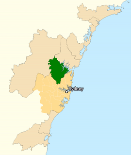
The Division of Berowra is an Australian electoral division in the state of New South Wales.
Maroota is a suburb to the north-west of Sydney, New South Wales, Australia. Maroota is located 49 kilometres north-west of the Sydney central business district, in the local government areas of The Hills Shire and Hornsby Shire.

South Maroota is a suburb in Sydney, New South Wales, Australia 72 kilometres north-west of the Sydney central business district in the local government area of The Hills Shire. The Hawkesbury River forms part of its western boundary.

Hawkesbury is an electoral district of the Legislative Assembly in the Australian state of New South Wales. It is represented by Robyn Preston of the Liberal Party.

The Muogamarra Nature Reserve is a protected nature reserve that is located in the Sydney region of New South Wales, in eastern Australia. The 2,274-hectare (5,620-acre) reserve is situated in the northern edge of Sydney and lies between the suburb of Cowan to the south, and the Hawkesbury River to the north.
Dillwynia tenuifolia is a rare plant endemic to New South Wales. It is a member of the tribe Mirbelieae which are known for their golden pea-shaped flowers.

Darbalara is a rural community on the east bank of the junction of the Murrumbidgee River and Tumut River in the Riverina. It is situated by road, about 25 kilometres north east of Gundagai and 25 kilometres south of Coolac.

For lands administrative purposes, New South Wales is divided into 141 counties, which are further divided into parishes. The counties were first set down in the Colony of New South Wales, which later became the Australian state of New South Wales.

Lands administrative divisions of Australia are the cadastral divisions of Australia for the purposes of identification of land to ensure security of land ownership. Most states term these divisions as counties, parishes, hundreds, and other terms. The eastern states of Queensland, New South Wales, Victoria and Tasmania were divided into counties and parishes in the 19th century, although the Tasmanian counties were renamed land districts in the 20th century. Parts of South Australia (south-east) and Western Australia (south-west) were similarly divided into counties, and there were also five counties in a small part of the Northern Territory. However South Australia has subdivisions of hundreds instead of parishes, along with the Northern Territory, which was part of South Australia when the hundreds were proclaimed. There were also formerly hundreds in Tasmania. There have been at least 600 counties, 544 hundreds and at least 15,692 parishes in Australia, but there are none of these units for most of the sparsely inhabited central and western parts of the country.

The Hundred of Sydney is a former lands administrative division for the city of Sydney. It was one of the thirteen hundreds in the County of Cumberland, which were published in the government gazette of May 27, 1835, and repealed on January 21, 1888. It included nine parishes ; the four small parishes in the Sydney city area: St Andrew, St James, St Lawrence and St Philip, as well as five larger parishes further away from the city: Concord, Petersham, Alexandria, Botany and St George. Its boundaries were the Parramatta River/Sydney Harbour to the north, Botany Bay/Georges River to the south, while the western boundary included part of Haslams Creek and Salt Pan Creek.
The Parish of Nattery is a parish of Argyle County located between Goulburn and Marulan in New South Wales. It is just east of the village of Towrang and includes the locality of Carrick. The Wollondilly River is the boundary in the north-west. Jerraba creek is part of the boundary in the south-east. The Southern Highlands railway line runs through the northern end of the parish, to the east of the Wollondilly river. The Hume Highway passes through the middle of the parish.
Rock Flat Creek is a watercourse that is part of the Murrumbidgee catchment within the Murray–Darling basin. It is located in the Monaro region of New South Wales, Australia.

Darwinia biflora is a plant in the myrtle family Myrtaceae and is endemic to New South Wales. It is an erect, often straggly shrub with flattened, glabrous leaves, and flowers which are arranged in pairs. The flowers are greenish in colour but each is surrounded by two purple-red bracteoles and have a long yellow-green style projecting out of the flower tube. The species only occurs in the Sydney region in a few places where shale-capped ridges intergrade with Hawkesbury sandstone.
Nanima is a locality in the Yass Valley Council area, New South Wales, Australia. It lies on the both sides of the Murrumbateman Road between Murrumbateman and Gundaroo, about 37 km north of Canberra. At the 2016 census, it had a population of 165.

Yarrangobilly, New South Wales is a rural locality in the Snowy Mountains, west of Canberra, Australia, and is also a civil Parish of Buccleuch County.
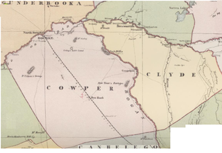
Maffra Parish, New South Wales is a Bounded locality of Bourke Shire and a civil Parish of Cowper County, New South Wales, a cadasteral division of central New South Wales.
| | This article related to the geography of Sydney is a stub. You can help Wikipedia by expanding it. |
| | This New South Wales geography article is a stub. You can help Wikipedia by expanding it. |