
Doonside is a suburb in Sydney, in the state of New South Wales, Australia. Doonside is located 40 kilometres west of the Sydney central business district, in the local government area of the City of Blacktown and is part of the Greater Western Sydney region. Featherdale Wildlife Park and the Nurragingy Nature Reserve are popular local tourist attractions.

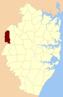
The Division of Chifley is an Australian electoral division in the state of New South Wales.
Marayong is a suburb of Sydney, in the state of New South Wales, Australia. Marayong is located 32 kilometres north west of the Sydney central business district, in the local government area of the City of Blacktown and is part of the Greater Western Sydney region.

Rooty Hill is a suburb of Sydney, in the state of New South Wales, Australia. Rooty Hill is located 42 kilometres west of the Sydney central business district, in the local government area of the City of Blacktown and is part of the Greater Western Sydney region.

The Hills District is a customary region of Sydney, within the northern part of the Greater Western Sydney region of Sydney, in the state of New South Wales, Australia. Stretching from the M2 Hills Motorway in the south to the Hawkesbury River in the north and Old Windsor Road in the West to Pennant Hills Road in the East, its constituent suburbs are located in the local government areas of The Hills Shire the Hornsby Shire
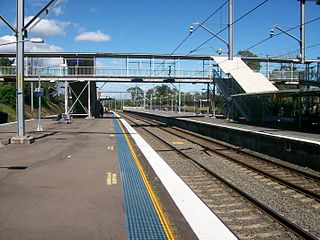
Doonside railway station is located on the Main Western line, serving the Sydney suburb of Doonside. It is served by Sydney Trains T1 Western line services.

Rooty Hill railway station is located on the Main Western line, serving the Sydney suburb of Rooty Hill. It is served by Sydney Trains T1 Western line services.

Blacktown railway station is located on the Main Western line, serving the Sydney suburb of Blacktown. It is served by Sydney Trains T1 Western Line and T5 Cumberland Line services and NSW TrainLink Intercity Blue Mountains Line and regional Central West XPT services.

Rooty Hill is a heritage-listed historic site and now parkland at Eastern Road, Rooty Hill, City of Blacktown, New South Wales, Australia. It was built from 1802 to 1828. It is also known as The Rooty Hill and Morreau Reserve. The property is owned by the Presbyterian Church (NSW) Property Trust. It was added to the New South Wales State Heritage Register on 13 June 2007.
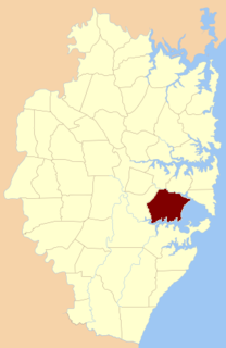
St George Parish is one of the 57 parishes of Cumberland County, New South Wales, a cadastral unit for use on land titles. It is bounded in the north by the Cooks River, in the west of Cox's Creek and Salt Pan Creek, and in the south by the Georges River.

Concord Parish is one of the 57 parishes of Cumberland County, New South Wales, a cadastral unit for use on land titles. It is located to the south of the Parramatta River between Homebush Bay and Iron Cove; and to the north of Cooks River. It includes the suburbs of Homebush, most of Strathfield, Burwood, Croydon, Concord, Canada Bay and Abbotsford. It covers the local government areas of City of Canada Bay and the Municipality of Burwood and most of the Municipality of Strathfield. It roughly corresponds to the western half of the Inner West region, with the neighbouring Parish of Petersham making up the eastern half.

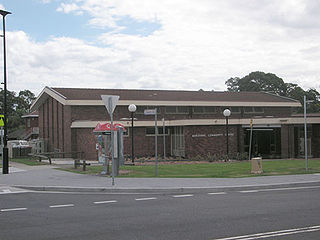
St Agnes Catholic High School is an independent Roman Catholic co-educational secondary day school, located in Rooty Hill, in the western suburbs of Sydney, New South Wales, Australia. The school caters for approximately 800 students from Year 7 to Year 12 and draws students from St Aidan's Primary, Rooty Hill, Sacred Heart Primary, Mount Druitt, and St John Vianney's Primary, Doonside, as well as a number of other schools in the surrounding suburbs. It also serves the parishes of St Aidan's Rooty Hill, Sacred Heart South Mount Druitt, Holy Family Emerton and St John Vianney's Doonside. The school is a Franciscan Missionaries of Mary school maintaining the Franciscan spirit of simplicity, acceptance of all and a deep personal love of Jesus.

The parish of Doonside is an Australian cadastral parish in the NSW county of Narromine. It is located approximately midway between Tottenham and Narromine and is in Narromine Shire. The parish should not be confused with the western Sydney suburb of Doonside.
Eastern Creek, a watercourse that is part of the Hawkesbury-Nepean catchment, is located in Greater Western Sydney, New South Wales, Australia.
Parish of Gidley, is one of the 57 civil parishes of the County of Cumberland.
Parish of St Matthews, is one of the 57 civil parishes of the County of Cumberland, New South Wales.
Castlereagh Parish, is a civil parish of Cumberland County, located west of Sydney in New South Wales, Australia.
Parish of Nelson, is a civil parish of the County of Cumberland, north west of Sydney, Australia.

Imperial Hotel is a heritage-listed Australian pub at 1 Rooty Hill Road North, Rooty Hill, City of Blacktown, Sydney, New South Wales, Australia. The property is owned by Dyemist Pty Ltd. It was added to the New South Wales State Heritage Register on 2 April 1999.

The Bungarribee Homestead Site is a heritage-listed archaeological site at the location of the former Bungarribee Homestead. The site is located at Doonside Road, Doonside, City of Blacktown, Sydney New South Wales, Australia. It was added to the New South Wales State Heritage Register on 8 December 2000.

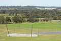 View from the Rooty Hill, Rooty Hill, Sydney, looking across Morreau Reserve
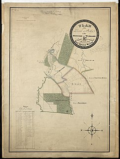
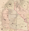 Map of the Parish in 1840. [2]
