Paričjak

Last updated
Paričjak
Slovenia location map.svg
Red pog.svg
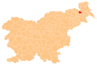
Paričjak
Location in Slovenia
Coordinates: 46°37′31.15″N16°2′27.33″E / 46.6253194°N 16.0409250°E / 46.6253194; 16.0409250 Coordinates: 46°37′31.15″N16°2′27.33″E / 46.6253194°N 16.0409250°E / 46.6253194; 16.0409250
Country Flag of Slovenia.svg Slovenia
Traditional region Styria
Statistical region Mura
Municipality Radenci
Area
  Total 0.77 km2 (0.30 sq mi)
Elevation 249.9 m (819.9 ft)
Population (2002)
  Total 251
[1]

Paričjak (pronounced  [paˈɾiːtʃjak] ) is a settlement in the Municipality of Radenci in northeastern Slovenia. It lies along the road from Radenci to Kapelski Vrh. [2]

Municipality An administrative division having corporate status and usually some powers of self-government or jurisdiction

A municipality is usually a single administrative division having corporate status and powers of self-government or jurisdiction as granted by national and regional laws to which it is subordinate. It is to be distinguished (usually) from the county, which may encompass rural territory or numerous small communities such as towns, villages and hamlets.

Radenci Town in Slovenia

Radenci is a town on the right bank of the Mura River in the Mura Statistical Region of northeastern Slovenia. It is a well-known spa town and was first mentioned in written documents dating back to 1436. After 1833, when a new source of mineral water was discovered, it developed into a popular resort. Since 1994 it has been the centre and the largest settlement of the Municipality of Radenci.

Slovenia republic in Central Europe

Slovenia, officially the Republic of Slovenia, is a sovereign state located in southern Central Europe at a crossroads of important European cultural and trade routes. It is bordered by Italy to the west, Austria to the north, Hungary to the northeast, Croatia to the southeast, and the Adriatic Sea to the southwest. It covers 20,273 square kilometers (7,827 sq mi) and has a population of 2.07 million. One of the successor states of the former Yugoslavia, Slovenia is a parliamentary republic and a member of the United Nations, of the European Union, and of NATO. The capital and largest city is Ljubljana.

There is a chapel-shrine with a belfry in the settlement. It was built in the early 20th century. [3]

Wayside shrine religious image, usually in some sort of small shelter, placed by a road or pathway

A wayside shrine is a religious image, usually in some sort of small shelter, placed by a road or pathway, sometimes in a settlement or at a crossroads, but often in the middle of an empty stretch of country road, or at the top of a hill or mountain. They have been a feature of many cultures, including Catholic and Orthodox Europe and Shinto Japan.

Bell tower a tower that contains one or more bells, or that is designed to hold bells

A bell tower is a tower that contains one or more bells, or that is designed to hold bells even if it has none. Such a tower commonly serves as part of a church, and will contain church bells, but there are also many secular bell towers, often part of a municipal building, an educational establishment, or a tower built specifically to house a carillon. Church bell towers often incorporate clocks, and secular towers usually do, as a public service.

Related Research Articles

Janžev Vrh Place in Styria, Slovenia

Janžev Vrh is a dispersed settlement above Boračeva in the Municipality of Radenci in northeastern Slovenia.

Kapelski Vrh Place in Styria, Slovenia

Kapelski Vrh is a settlement in the Municipality of Radenci in northeastern Slovenia.

Kocjan, Radenci Place in Styria, Slovenia

Kocjan is a small settlement in the Municipality of Radenci in northeastern Slovenia.

Melanjski Vrh Place in Styria, Slovenia

Melanjski Vrh is a small settlement in the Municipality of Radenci in northeastern Slovenia.

Murščak Place in Styria, Slovenia

Murščak is a settlement in the Municipality of Radenci in northeastern Slovenia.

Okoslavci Place in Styria, Slovenia

Okoslavci is a settlement in the Municipality of Radenci in northeastern Slovenia.

Radenski Vrh Place in Styria, Slovenia

Radenski Vrh is a settlement in the Municipality of Radenci in northeastern Slovenia.

Rački Vrh Place in Styria, Slovenia

Rački Vrh is a settlement in the hills west of Hrastje in the Municipality of Radenci in northeastern Slovenia.

Rihtarovci Place in Styria, Slovenia

Rihtarovci is a small settlement on the right bank of the Mura River in the Municipality of Radenci in northeastern Slovenia.

Turjanci Place in Styria, Slovenia

Turjanci is a settlement on the right bank of the Mura River in the Municipality of Radenci in northeastern Slovenia. It lies on the main road from Radenci to Ljutomer.

Zgornji Kocjan Place in Styria, Slovenia

Zgornji Kocjan is a small settlement in the hills above Mota in the Municipality of Radenci in northeastern Slovenia.

Žrnova Place in Styria, Slovenia

Žrnova is a small dispersed settlement in the Municipality of Radenci in northeastern Slovenia.

Dolenji Radenci in White Carniola, Slovenia

Dolenji Radenci is a small settlement on the left bank of the Kolpa River in the Municipality of Črnomelj in the White Carniola area of southeastern Slovenia. The area is part of the traditional region of Lower Carniola and is now included in the Southeast Slovenia Statistical Region.

Gorenji Radenci in White Carniola, Slovenia

Gorenji Radenci is a settlement on the left bank of the Kolpa River in the Municipality of Črnomelj in the White Carniola area of southeastern Slovenia. The area is part of the traditional region of Lower Carniola and is now included in the Southeast Slovenia Statistical Region.

Srednji Radenci in White Carniola, Slovenia

Srednji Radenci is a small settlement on the left bank of the Kolpa River 4.5 km south of Stari Trg ob Kolpi in the Municipality of Črnomelj in the White Carniola area of southeastern Slovenia. The area is part of the traditional region of Lower Carniola and is now included in the Southeast Slovenia Statistical Region.

Zorenci Place in White Carniola, Slovenia

Zorenci is a settlement on the left bank of the Lahinja River south of Črnomelj in the White Carniola area of southeastern Slovenia. The area is part of the traditional region of Lower Carniola and is now included in the Southeast Slovenia Statistical Region.

Lukavci in Styria, Slovenia

Lukavci is a village in the Municipality of Križevci in northeastern Slovenia. It lies just off the regional road leading northwest from Ljutomer to Radenci. Traditionally the area was part of Styria. The entire municipality is now included in the Mura Statistical Region.

Stara Nova Vas Place in Styria, Slovenia

Stara Nova Vas is a village in the Municipality of Križevci in northeastern Slovenia. It lies on the regional road from Ljutomer to Radenci in the traditional region of Styria. The entire municipality is now included in the Mura Statistical Region.

Municipality of Radenci Municipality in Slovenia

The Municipality of Radenci is a municipality in northern Slovenia. It gets its name from the largest settlement and administrative centre of the municipality, Radenci.

References