Parks Creek

Last updated
Parks Creek
Stream
Country United States
State Missouri
Region Wright and Laclede counties
Source
 - coordinates 37°19′23″N92°36′39″W / 37.32306°N 92.61083°W / 37.32306; -92.61083
Mouth
 - elevation1,076 ft (328 m)
 - coordinates 37°30′13″N92°37′27″W / 37.50361°N 92.62417°W / 37.50361; -92.62417
[1]

Parks Creek is a stream in Wright and Laclede counties in the Ozarks of southern Missouri. [1] It is a tributary of the Osage Fork Gasconade River.

Stream A body of surface water flowing down a channel

A stream is a body of water with surface water flowing within the bed and banks of a channel. The stream encompasses surface and groundwater fluxes that respond to geological, geomorphological, hydrological and biotic controls.

Wright County, Missouri County in the United States

Wright County is a county located in the southern portion of the U.S. state of Missouri. As of the 2010 census, the population was 18,815. Its county seat is Hartville. The county was officially organized on January 29, 1841, and is named after Silas Wright, a former Congressman, U.S. Senator and Governor of New York.

Laclede County, Missouri County in the United States

Laclede County is a county located in the U.S. state of Missouri. As of the 2010 census, the population was 35,571. Its county seat is Lebanon. The county was organized February 24, 1849, and was named after Pierre Laclède, founder of St. Louis.

Contents

Parks Creek begins at the confluence of two valleys south of Grovespring and just west of Missouri Route 5. The stream flows essentially due north parallel to Route 5 and joins the Osage Fork in southern Laclede County just northeast of Pease and the Missouri Route J bridge. In northernmost Wright County the stream flows through the Dr John Alva Fuson Conservation Area. Parks Creek Road follows the stream from Grovespring north to Route J. [2]

Grovespring, Missouri unincorporated community in Missouri

Grovespring is an unincorporated community in Wright County, Missouri, United States. It is located on Missouri Route 5, approximately 20 miles (32 km) south of Lebanon, Missouri in neighbouring Laclede County.
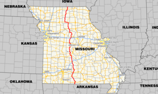
Missouri Route 5 highway in Missouri

Missouri Route 5 is the longest state highway in Missouri and the only Missouri state highway to traverse the entire state. It is part of a three state, 650 mile highway 5. To the north, it continues into Iowa as Iowa Highway 5 and to the south it enters Arkansas as Highway 5. With only a few exceptions, it is two-lane for its entire length. Business Route 5 serves Milan and Ava.

Pease is an unincorporated community in Laclede County, in the Ozarks of southern Missouri. Pease is located along the Osage Fork Gasconade River, just upstream of the Missouri Route J crossing and the confluence of Parks Creek with the Osage Fork.

Parks Creek has the name of the local Parks family. [3]

See also

Related Research Articles

Gasconade River river in the United States of America

The Gasconade River is about 280 miles (450 km) long and is located in central and south-central Missouri in the United States.

The Osage Fork Gasconade River is a stream in Wright, Webster and Laclede counties in the Ozarks of southern Missouri. It is a tributary of the Gasconade River.

Little Osage River tributary of the Osage River in eastern Kansas and western Missouri in the United States

The Little Osage River is an 88-mile-long (142 km) tributary of the Osage River in eastern Kansas and western Missouri in the United States. Via the Osage and Missouri rivers, it is part of the watershed of the Mississippi River.

Niangua River river in the United States of America

The Niangua River is a 125-mile-long (201 km) tributary of the Osage River in the Ozarks region of southern and central Missouri in the United States. Via the Osage and Missouri rivers it is part of the watershed of the Mississippi River.

Rader, pronounced locally as "rā dŗ", is an unincorporated community in southern Laclede County, Missouri, United States. It is about fifteen miles south of Lebanon at the intersection of Missouri Supplemental Routes ZZ and the Osage fork of the Gasconade River. Rader is served by the post office in Conway.

Clifty Creek is a stream in eastern Douglas and southeastern Wright counties of Missouri. It is a tributary of the North Fork River.

Brush Creek is a stream in southern Laclede County in the U.S. state of Missouri. It is a tributary of the Osage Fork Gasconade River.

Cobb Creek is a stream in extreme northern Wright and south-central Laclede counties in the Ozarks of southern Missouri. It is a tributary of the Osage Fork Gasconade River. The stream origin is just southeast of Origanna and east of State Route TT. The stream flows NNE past Agnes, receives the waters of Blue Spring and flows just west of Drew. The stream joins the Osage Fork northwest of Drew. The elevation of the stream confluence is 961 ft (293 m).

Panther Creek is a stream in Webster and Laclede counties in the Ozarks of south-central Missouri. It is a tributary of the Osage Fork Gasconade River. The headwaters are at 37°29′09″N92°49′42″W and the confluence with the Osage Fork is at 37°28′48″N92°42′44″W.

Tavern Creek is a stream in Miller and Pulaski counties in the U.S. state of Missouri. It is a tributary of the Osage River. The stream headwaters are at 37°54′42″N92°22′19″W and the confluence with the Osage is at 38°19′04″N92°17′24″W.

Saline Creek is a stream in northern Miller County in the U.S. state of Missouri. It is a tributary of the Osage River.

Wright Creek is a stream in St. Clair County in the U.S. state of Missouri. It is a tributary to the Osage River within the Truman Reservoir.

Little Creek is a stream in Wright, Texas and Douglas counties of Missouri. It is a tributary of the North Fork River.

Femme Osage Creek is a stream in St. Charles County in the U.S. state of Missouri. It is a tributary of the Missouri River.

Elk Creek is a stream in central to northeast Wright County, Missouri. It is a tributary of the Gasconade River.

Spring Creek is a stream in Douglas and Howell counties in the Ozarks of southern Missouri.

Core Creek (Osage Fork Gasconade River)

Core Creek is a small stream in Laclede County, Missouri. It is a tributary of the Osage Fork Gasconade River.

Beaver Creek is a stream in southwestern Texas and eastern Wright counties in the Ozarks of southern Missouri. It is a tributary of the Gasconade River.

References

  1. 1 2 U.S. Geological Survey Geographic Names Information System: Parks Creek
  2. Missouri Atlas & Gazetteer, DeLorme, 1998, First edition, p. 53, ISBN   0-89933-224-2
  3. "Laclede County Place Names, 1928–1945 (archived)". The State Historical Society of Missouri. Archived from the original on 24 June 2016. Retrieved 24 October 2016.