Look up parkway in Wiktionary, the free dictionary.
A parkway is a landscaped thoroughfare (road).
Contents
Parkway or Park Way may also refer to:
A parkway is a landscaped thoroughfare (road).
Parkway or Park Way may also refer to:
Gateway often refers to:

The Great River Road is a collection of state and local roads that follow the course of the Mississippi River through ten states of the United States. They are Minnesota, Wisconsin, Iowa, Illinois, Missouri, Kentucky, Tennessee, Arkansas, Mississippi and Louisiana. It formerly extended north into Canada, serving the provinces of Ontario and Manitoba. The road is designated as both a National Scenic Byway and an All-American Road in several states along the route.
Saint Charles may refer to:
Newbury may refer to:
Darlington is a large market town in County Durham, North East England.

A parkway is a landscaped thoroughfare. The term is particularly used for a roadway in a park or connecting to a park from which trucks and other heavy vehicles are excluded.
La Salle, LaSalle or Lasalle is part of the names of two men born in 17th century France, Jean-Baptiste de La Salle and René-Robert Cavelier, Sieur de La Salle, for whom many places and things are named:
A National Parkway is a designation for a protected area in the United States given to scenic roadways with a protected corridor of surrounding parkland. National Parkways often connect cultural or historic sites. The U.S. National Park Service manages the parkways.
Kingsway or King's Way may refer to:
Hermitage, The Hermitage or L'Hermitage may refer to:
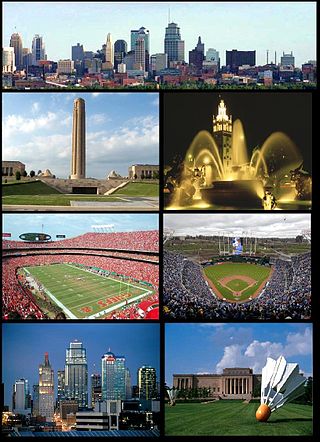
The Kansas City metropolitan area is a bi-state metropolitan area anchored by Kansas City, Missouri. Its 14 counties straddle the border between the U.S. states of Missouri and Kansas. With 8,472 square miles (21,940 km2) and a population of more than 2.2 million people, it is the second-largest metropolitan area centered in Missouri and is the largest metropolitan area in Kansas, though Wichita is the largest metropolitan area centered in Kansas. Alongside Kansas City, Missouri, these are the suburbs with populations above 100,000: Overland Park, Kansas; Kansas City, Kansas; Olathe, Kansas; Independence, Missouri; and Lee's Summit, Missouri.
Drury may refer to:

Didcot Parkway is a railway station serving Didcot, a town in Oxfordshire, England. The station was opened as Didcot on 12 June 1844 and was renamed Didcot Parkway on 29 July 1985 by British Rail, to reflect its role as a park and ride railhead. It is 53 miles 10 chains down the line from London Paddington and is situated between Cholsey to the east and Swindon to the west.
Harry S. Truman (1884–1972) was the president of the United States from 1945 to 1953.

A bypass is a road or highway that avoids or "bypasses" a built-up area, town, or village, to let through traffic flow without interference from local traffic, to reduce congestion in the built-up area, to improve road safety and as replacement for obsolete roads that no longer in use because devastating natural disasters. A bypass specifically designated for trucks may be called a truck route.
Stone House — or Stonehouse — may refer to:
Rock Creek or Rockcreek may refer to:
Newmarket may refer to:
Kingsbury may refer to:

Crowley's Ridge Parkway is a 212.0-mile-long (341.2 km) National Scenic Byway in northeast Arkansas and the Missouri Bootheel along Crowley's Ridge in the United States. Motorists can access the parkway from US Route 49 (US 49) at its southern terminus near the Helena Bridge over the Mississippi River outside Helena-West Helena, Arkansas, or from Missouri Route 25 (Route 25) near Kennett, Missouri. The parkway runs along Crowley's Ridge, a unique geological formation, and also parts of the St. Francis National Forest, the Mississippi River and the Mississippi Alluvial Plain. Along the route are many National Register of Historic Places properties, Civil War battlefields, parks, and other archeological and culturally significant points.